 view gallery view gallery SW29.8 km SW29.8 km
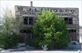
|   B. J. LUND Co. ... ... HOTEL - Modena, Utah B. J. LUND Co. ... ... HOTEL - Modena, Utah
in Ghost Signs Old building in Modena Utah. posted by:  nvtriker nvtriker location: Utah date approved: 05/26/2009 last visited: never |
 view gallery view gallery S33.2 km S33.2 km
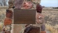
|  Pioneer Park - Beryl Junction, UT Pioneer Park - Beryl Junction, UT
in Municipal Parks and Plazas This modest park contains little other than a shelter and a monument - in Beryl Junction, Utah. posted by: The Snowdog location: Utah date approved: 01/01/2023 last visited: never |
 view gallery view galleryS39.3 km |  New Castle, Utah New Castle, Utah
in Wikipedia Entries I was surprised little New Castle even has a page, but there's not much to it yet. posted by: JacobBarlow location: Utah date approved: 02/01/2008 last visited: 02/12/2011 |
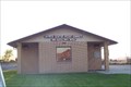 view gallery view galleryS39.3 km |  New Castle, UT 84756 New Castle, UT 84756
in U.S. Post Offices New Castle, Utah 84756 posted by: PeanutsParents location: Utah date approved: 09/30/2007 last visited: 09/17/2011 |
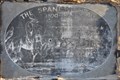
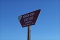
 view gallery view galleryS39.6 km |  The Spanish Trail The Spanish Trail
in Wagon Roads and Trails This marker is located where the Old Spanish Trail crosses Utah Highway 56 just east of New Castle, Utah. posted by: brwhiz location: Utah date approved: 04/19/2012 last visited: never |
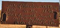
 view gallery view galleryS39.6 km |  The Spanish Trail ~ 1800-1850 The Spanish Trail ~ 1800-1850
in Utah Historical Markers This marker was placed where the Old Spanish Trail crosses Utah Highway 56 just east of New Castle, Utah. posted by: brwhiz location: Utah date approved: 05/18/2012 last visited: never |
 view gallery view galleryS39.9 km | Site of Blacksmith Shop on Spanish Trail in Utah Historical Markers This rather primitive historic marker is comprised of free-hand script welding on a steel plate. posted by: brwhiz location: Utah date approved: 04/19/2012 last visited: never |
 view gallery view gallery W40.1 km W40.1 km
|  Spring Valley Cemetery - State Line Canyon, Pioche, NV Spring Valley Cemetery - State Line Canyon, Pioche, NV
in Abandoned Cemeteries A small cemetery with few surviving headstones in the BLM Ely district near Pioche. There are 15 graves listed. posted by: ChapterhouseInc location: Nevada date approved: 03/08/2012 last visited: 08/07/2011 |
 view gallery view galleryW40.1 km |  Spring Valley Cemetery - State Line Canyon, Pioche, NV Spring Valley Cemetery - State Line Canyon, Pioche, NV
in Worldwide Cemeteries A small cemetery with few surviving headstones in the BLM Ely district near Pioche. There are 15 graves listed. posted by: ChapterhouseInc location: Nevada date approved: 03/13/2012 last visited: 08/07/2011 |
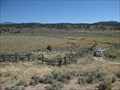
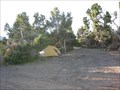
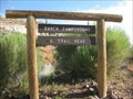 view gallery view galleryW42 km |  Ranch Campground and Trailhead - Spring Valley State Park Ranch Campground and Trailhead - Spring Valley State Park
in Campgrounds A smaller campground north of the main campground at Spring Valley State Park. posted by: ChapterhouseInc location: Nevada date approved: 08/31/2011 last visited: 07/24/2011 |
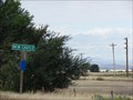
 view gallery view gallerySW43.5 km |  Utah Nevada Highway 56 Utah Nevada Highway 56
in Border Crossings Border Crossing on highway 56 posted by:  caverspencer caverspencer location: Utah date approved: 02/25/2007 last visited: 05/29/2014 |
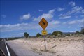 view gallery view gallerySW43.6 km |  Bull? Crossing Hwy 56 West of UT/NV stateline Bull? Crossing Hwy 56 West of UT/NV stateline
in Uncommon Crossing Signs Bull? Crossing...I've seen lots of cattle crossing signs. Just never seen a BULL crossing. Even has a lasso around it's neck. posted by: PeanutsParents location: Nevada date approved: 09/30/2007 last visited: 04/01/2021 |
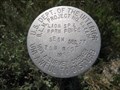
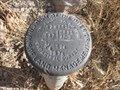 view gallery view galleryW43.6 km |  T2NR69E - USDOI BLM T2NR69E - USDOI BLM
in U.S. Benchmarks Set in a pulloff for Spring Lake State Park. posted by: ChapterhouseInc location: Nevada date approved: 08/11/2011 last visited: 08/07/2011 |
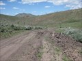
 view gallery view gallerySW44.3 km | Nevada / Utah Border Crossing ( Uvada dirt road ) in Border Crossings Along a dirt road that turns south from highway 56 West of Uvada, UT.
posted by: PeanutsParents location: Utah date approved: 10/15/2007 last visited: 05/29/2014 |
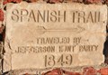 view gallery view galleryS45.1 km | Spanish Trail vs Shortcut in Utah Historical Markers These cast concrete plates, mounted on a stone monument, mark the spot where the Jefferson Hunt party of 1849 split up about 5.7 miles southwest of New Castle, Utah. posted by: brwhiz location: Utah date approved: 04/17/2013 last visited: never |
 view gallery view galleryS45.1 km | Jefferson Hunt in Utah Historical Markers This Historical Marker is mounted on a steel post near a stone monument on an unnamed road south of New Castle, Utah. posted by: brwhiz location: Utah date approved: 04/17/2013 last visited: never |
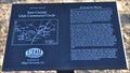 view gallery view galleryS45.1 km |  Utah Statehood ~ Jefferson Hunt Utah Statehood ~ Jefferson Hunt
in Community Commemoration This Historical Marker, erected in 1996 to celebrate the centennial of Utah statehood, is located near a stone monument on an unnamed road south of New Castle, Utah. posted by: brwhiz location: Utah date approved: 04/18/2013 last visited: never |
 view gallery view gallery NW45.1 km NW45.1 km
|  White Rock Range Wilderness - NV White Rock Range Wilderness - NV
in Public Access Lands The White Rock Mountain Wilderness provides access to hiking, hunting, off roading (ATV/UTV) and wildlife viewing. posted by: ChapterhouseInc location: Nevada date approved: 06/20/2011 last visited: 06/15/2011 |
 view gallery view galleryW45.4 km |  Eagle Valley Fort Eagle Valley Fort
in Nevada Historical Markers An old marker notating Brigham Youngs directive to settle this valley. posted by: ChapterhouseInc location: Nevada date approved: 05/03/2012 last visited: 08/07/2011 |
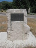
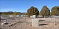
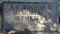 view gallery view galleryS46.8 km | A. P. Windsor II Memorial Cemetery in Utah Historical Markers This marker has been placed on what appears to be an empty tomb constructed of rock in the rough shape of a beehive. posted by: brwhiz location: Utah date approved: 04/17/2012 last visited: never |
 view gallery view galleryS46.8 km | A. P. Windsor II Memorial Cemetery in Worldwide Cemeteries This very small cemetery is located at approximately 500 N Center Street on the north side of Enterprise, Utah. posted by: brwhiz location: Utah date approved: 04/18/2013 last visited: never |
 view gallery view galleryNW47 km | White Rock Range Wilderness Camping Areas - NV in Free Campsites There are several assorted camping areas scattered around the White Rock Mountain Wilderness. posted by: ChapterhouseInc location: Nevada date approved: 08/14/2011 last visited: 06/14/2011 |
 view gallery view galleryNW47 km | Lion Spring - White Rock Mountain Wilderness Area in U.S. Benchmarks A benchmark set near the southwest corner protecting the fence. posted by: ChapterhouseInc location: Nevada date approved: 06/19/2011 last visited: 06/14/2011 |
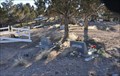
 view gallery view galleryS47 km | Hebron Cemetery in Worldwide Cemeteries This Cemetery is located a short distance north of Utah Highway 219, on the north side of Shoal Creek, about 7 miles west of Enterprise, Utah. posted by: brwhiz location: Utah date approved: 04/18/2013 last visited: never |
 view gallery view galleryS47.2 km |  Hebron: Pioneer Settlement on Shoal Creek Hebron: Pioneer Settlement on Shoal Creek
in Ghost Towns The pioneer cemetery is all that remains of the small rural agricultural community of Hebron, about 7 miles west of Enterprise, Utah. posted by: brwhiz location: Utah date approved: 04/16/2013 last visited: never |
|