 view gallery view gallery N2.4 km N2.4 km
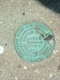
|   EWELL (GV3605) RM 2 - Ewell, MD EWELL (GV3605) RM 2 - Ewell, MD
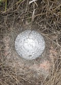
in U.S. Benchmarks Reference Mark located on the W edge of the town of Ewell. posted by:  Ernmark Ernmark location: Maryland date approved: 07/09/2011 last visited: never |
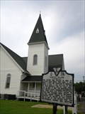
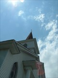 view gallery view galleryN2.4 km | Ewell Methodist Church Spire (GV3611) - Ewell, MD in U.S. Benchmarks The tallest point in town serves as an Intersection Station 'benchmark' on the Smith Island town of Ewell, Maryland. posted by: Ernmark location: Maryland date approved: 09/21/2014 last visited: never |
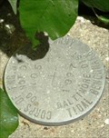
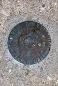 view gallery view galleryN2.4 km | 857 1117 A - Ewell, MD in U.S. Benchmarks Tidal benchmark located in front of the Methodist Church in Ewell, MD posted by: Ernmark location: Maryland date approved: 07/26/2011 last visited: never |
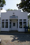 view gallery view galleryN2.4 km |  Ewell, MD - 21824 Ewell, MD - 21824
in U.S. Post Offices Small Post Office serving the town of Ewell on Smith Island. posted by: Ernmark location: Maryland date approved: 07/24/2011 last visited: never |
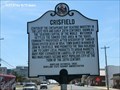
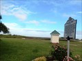
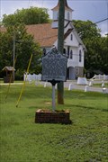 view gallery view galleryN2.4 km |  Smith Island - Ewell, MD Smith Island - Ewell, MD
in Maryland Historical Markers Marker located in the small island town of Ewell, MD. posted by: Ernmark location: Maryland date approved: 07/23/2011 last visited: never |
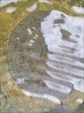
 view gallery view galleryN2.6 km | 857 1117 TIDAL 5 - Ewell, MD in U.S. Benchmarks Tidal benchmark located on the N side of Caleb Jones RD in Ewell, MD. posted by: Ernmark location: Maryland date approved: 07/26/2011 last visited: never |
 view gallery view gallery SE10.9 km SE10.9 km
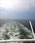
|  Maryland / Virginia Border Crossing - Crisfield, MD - Tangier Island, VA Ferry Maryland / Virginia Border Crossing - Crisfield, MD - Tangier Island, VA Ferry
in Border Crossings Water crossing from ferries based in Crisfield, MD & Tangier Island, VA. posted by: Ernmark location: Virginia date approved: 09/25/2012 last visited: 03/15/2014 |
 view gallery view gallery E15.6 km E15.6 km
| 857 1091 TIDAL 10 (FW0499) - Crisfield, MD in U.S. Benchmarks Disk embedded in street. Corner of Dock st and 12th st. posted by: originalta location: Maryland date approved: 10/19/2023 last visited: never |
 view gallery view galleryE15.6 km |  The Ice Cream Gallery The Ice Cream Gallery
in Ice Cream Parlors Ice Cream in the Crab Capitol of the World, Crisfield, Maryland posted by:  Rivers End Rivers End location: Maryland date approved: 07/11/2006 last visited: 07/12/2014 |
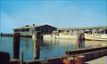 view gallery view galleryE15.6 km |  Crisfield (MD) Dock Crisfield (MD) Dock
in Photos Then and Now Views of the dock at Crisfield, Md. posted by: Rangerj location: Maryland date approved: 01/09/2006 last visited: 10/15/2023 |
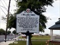
 view gallery view galleryE15.8 km | Crisfield in Maryland Historical Markers Crisfield-Center of the Chesapeake Bay seafood industry in the late 19th and early 20th centuries, known as the “Seafood Capital of the World.” posted by: Don.Morfe location: Maryland date approved: 10/24/2019 last visited: 10/15/2023 |
 view gallery view galleryE16.3 km |  The Great Pyramid of Crisfield (MD) The Great Pyramid of Crisfield (MD)
in Time Capsules 100 Year Time Capsule posted by: Rangerj location: Maryland date approved: 01/03/2006 last visited: never |
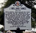
 view gallery view galleryE16.4 km | J. Millard Tawes in Maryland Historical Markers J. Millard Tawes 1894-1979-Born in Crisfield. Served Maryland for 37 years. Governor, 1959-1967. posted by: Don.Morfe location: Maryland date approved: 10/24/2019 last visited: 09/28/2021 |
 view gallery view galleryE16.4 km |  Crisfield Municipal Park - Crisfield MD Crisfield Municipal Park - Crisfield MD
in Municipal Parks and Plazas Crisfield Municipal Park on Maryland Avenue north of the Crisfield Historic District. posted by: Don.Morfe location: Maryland date approved: 10/17/2022 last visited: 10/16/2022 |
 view gallery view galleryE16.4 km |  ONLY - Marylander to be elected to the three positions of State Treasurer, Comptroller, and Governor - J. Millard Tawes - Crisfield MD ONLY - Marylander to be elected to the three positions of State Treasurer, Comptroller, and Governor - J. Millard Tawes - Crisfield MD
in Superlatives John Millard Tawes was the 54th Governor of Maryland from 1959 to 1967. He remains the only Marylander to be elected to the three positions of State Treasurer, Comptroller, and Governor. posted by: Don.Morfe location: Maryland date approved: 03/16/2023 last visited: 03/17/2023 |
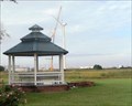 view gallery view galleryE16.4 km |  Gazebo at Crisfield Municipal Park - Crisfield MD Gazebo at Crisfield Municipal Park - Crisfield MD
in Gazebos The Gazebo is in Crisfield Municipal Park located on Maryland Ave in Crisfield. posted by: Don.Morfe location: Maryland date approved: 10/16/2022 last visited: 10/16/2022 |
 view gallery view galleryE16.4 km |  J. Millard Tawes - Crisfield MD J. Millard Tawes - Crisfield MD
in Citizen Memorials J. Millard Tawes 1894-1979-Born in Crisfield. Served Maryland for 37 years. Governor, 1959-1967. posted by: Don.Morfe location: Maryland date approved: 03/18/2023 last visited: 03/17/2023 |
 view gallery view gallery S16.6 km S16.6 km
| PILOT (FW1702) - Tangier Island, VA in U.S. Benchmarks Tidal Benchmark located at the N end of the airstrip on Tangier Island. posted by: Ernmark location: Virginia date approved: 09/25/2012 last visited: never |
 view gallery view galleryE16.7 km | Immanuel Methodist Church, Crisfield, MD in Photos Then and Now The photos, probably taken 75-80 years apart, show the same church. They were taken from opposite directions. posted by: Rangerj location: Maryland date approved: 01/09/2006 last visited: never |
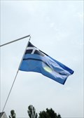 view gallery view galleryS16.7 km |  Municipal Flag - Tangier Island, VA Municipal Flag - Tangier Island, VA
in Municipal Flags Flag found in the small Chesapeake Bay island town of Tangier. posted by: Ernmark location: Virginia date approved: 09/24/2012 last visited: never |
 view gallery view galleryS16.9 km | TANGIER ISLAND SWAIN MEM CH (FW1343) - Tangier Island, VA in U.S. Benchmarks An 'intersection station' benchmark located on Tangier Island - the spire of the local church. posted by: Ernmark location: Virginia date approved: 09/25/2012 last visited: 03/16/2014 |
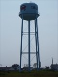 view gallery view galleryS16.9 km |  Tangier Water Tower Tangier Water Tower
in Water Towers The Tanger Water tower is the highest structure on the island. posted by: VirginiaSeeker location: Virginia date approved: 08/20/2012 last visited: never |
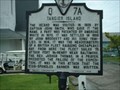 view gallery view galleryS16.9 km |  Tangier Island Tangier Island
in Virginia Historical Markers Tangier Island Historical Marker
Tangier Island, Virginia posted by: Rivers End location: Virginia date approved: 07/11/2006 last visited: 07/13/2013 |
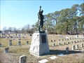 view gallery view galleryE17.2 km |  Spirit of the American Doughboy - Crisfield MD Spirit of the American Doughboy - Crisfield MD
in Viquesney's Spirit of the Doughboy Statues A Very intact statue in a graveyard on the Eastern Shore of MD. posted by:  THE DAM TROLLS THE DAM TROLLS location: Maryland date approved: 02/13/2009 last visited: never |
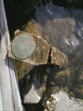 view gallery view galleryE17.4 km | Ramp in U.S. Benchmarks This waymark was somehow removed from its original 1991 location and found in rip rap running along the bank of the Daugherty Creek Canal. posted by: Rangerj location: Maryland date approved: 03/30/2015 last visited: never |
|