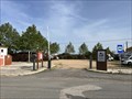
 view gallery view gallery NW4.7 km NW4.7 km
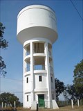
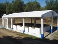
|   Depósito de água de Abela Depósito de água de Abela
in Water Towers Water Tower for Abela posted by:  MightyReek MightyReek location: Setúbal, Portugal date approved: 10/02/2009 last visited: never |
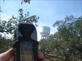 view gallery view galleryNW4.7 km |  ABELA ABELA
in Portugal Geodetic Points Marco geodésico: ABELA
Coordenadas: 38° 00.336 W008° 33.493
posted by: MightyReek location: Setúbal, Portugal date approved: 10/02/2009 last visited: never |
  NE7.4 km NE7.4 km
|  Monte Naturista O Barão Monte Naturista O Barão
in Nude Beaches Naturist Campsite
Parque Campismo Naturista posted by: MightyReek location: Setúbal, Portugal date approved: 07/26/2009 last visited: 05/30/2009 |
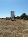 view gallery view galleryNE10.9 km |  Cereal Silo - Minas do Lousal, Portugal Cereal Silo - Minas do Lousal, Portugal
in Solitary Silos A solitary silo near Minas do Lousal posted by: tmob location: Setúbal, Portugal date approved: 09/09/2021 last visited: never |
 view gallery view gallery E11.4 km E11.4 km
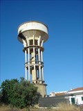
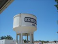
| Depósito de Água de Ermidas-Sado in Water Towers Water suply tower.
Depósito de abastecimento de água. posted by: MightyReek location: Setúbal, Portugal date approved: 07/25/2009 last visited: never |
 view gallery view galleryE11.4 km | Depósito de Água da Estação de Ermidas in Water Towers Water tower for the Railstation service.
Depósito de água para serviço da Estação. posted by: MightyReek location: Setúbal, Portugal date approved: 07/25/2009 last visited: never |
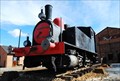
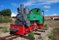 view gallery view galleryNE12.1 km |  Lousal Mines Locomotive #2 - Lousal, Portugal Lousal Mines Locomotive #2 - Lousal, Portugal
in Locomotives Ancient locomotive used to transport ore from the Lousal mines to the nearby major raillroad. posted by:  manchanegra manchanegra location: Setúbal, Portugal date approved: 02/22/2009 last visited: 04/06/2008 |
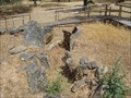 view gallery view galleryNE12.2 km |  Monumento Megalítico do Lousal Monumento Megalítico do Lousal
in Megalithic Monuments Monumento Megalítico do Lousal - Período Calcolítico - 2000
Lousal's Megalíthic Monument - Calcolithic Period 2000 b. C. posted by: MightyReek location: Setúbal, Portugal date approved: 07/19/2009 last visited: 07/31/2016 |
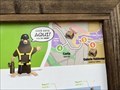 view gallery view galleryNE12.2 km |  Você está aqui! - you’re here! — Lagoa verde, Lousal, Portugal Você está aqui! - you’re here! — Lagoa verde, Lousal, Portugal
in 'You Are Here' Maps At the green lagoon. posted by: GEOrgCACHING location: Évora, Portugal date approved: 04/07/2024 last visited: 04/07/2024 |
 view gallery view galleryNE12.2 km |  Alentejo Ribatejo - Lousal, Portugal Alentejo Ribatejo - Lousal, Portugal
in Free Overnight RV Parking Locations Gratis camperspace with electricity posted by: GEOrgCACHING location: Évora, Portugal date approved: 04/08/2024 last visited: 04/08/2024 |
 view gallery view galleryNE12.4 km | Lousal Mines Locomotive #1 - Lousal, Portugal in Locomotives Ancient locomotive used to transport ore from the Lousal mines to the nearby major raillroad. posted by: manchanegra location: Setúbal, Portugal date approved: 02/22/2009 last visited: 04/06/2024 |
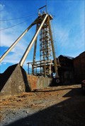 view gallery view galleryNE12.4 km |  Lousal Mines - Portugal Lousal Mines - Portugal
in Mines Lousal Mine was explored between 1900 and 1988 and is located in the Iberian Pyrit Belt. posted by: manchanegra location: Setúbal, Portugal date approved: 04/16/2009 last visited: 09/09/2007 |
 view gallery view galleryE12.9 km |  Alvalade Medieval, Alvalade, Portugal Alvalade Medieval, Alvalade, Portugal
in Renaissance Fairs Every year in September this medieval fair takes place in the village of Alvalade, commemorating its "foral" (500 years in 2010). posted by: Torgut location: Beja, Portugal date approved: 09/16/2011 last visited: 09/18/2005 |
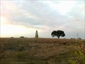
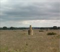
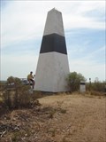 view gallery view galleryNE13 km | Barros - PE in Portugal Geodetic Points The Geodesic Vertex Barros-PE
Locally known as "gurita", the landmark that I propose that you visit is an extremely impressive and imposing structure. Here’s a summary of the place:
O Vértice Geodésico Barros-PE
Localmente conhecido como "gurita", o marco que vos proponho visitar é uma estrutura realmente impressionante e imponente.
Aqui está um resumo do local:
posted by: MightyReek location: Setúbal, Portugal date approved: 07/19/2009 last visited: 09/11/2010 |
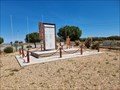 view gallery view galleryE14.5 km |  Guerra do Ultramar - Ermidas do Sado, Portugal Guerra do Ultramar - Ermidas do Sado, Portugal
in Specific Wars Monuments and Memorials This is a monument for the men of this area who fought in the Portuguese overseas posted by: Torgut location: Beja, Portugal date approved: 04/28/2023 last visited: never |
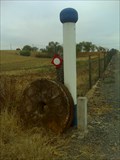 view gallery view galleryE14.5 km |  IC Ermidas do Sado - Ermidas do Sado, Portugal IC Ermidas do Sado - Ermidas do Sado, Portugal
in Millstones A pair of millstones by the road posted by: Torgut location: Beja, Portugal date approved: 08/12/2013 last visited: never |
 view gallery view gallery SE15 km SE15 km
| Barradinha - PW in Portugal Geodetic Points Vértice geodésico 1ª Ordem.
Altitude: 99, 7 mts
Coordenadas: N 37º 51.961 W 008º 25.490 posted by: MightyReek location: Beja, Portugal date approved: 11/12/2011 last visited: never |
 view gallery view gallery W15 km W15 km
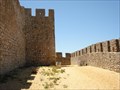
| ") Castelo de Santiago do Cacém - Santiago do Cacém, Portugal Castelo de Santiago do Cacém - Santiago do Cacém, Portugal
in Património Português (Portuguese Heritage) The Castle of Santiago do Cacém was declared as a National Monument in 1910 posted by: tmob location: Setúbal, Portugal date approved: 01/26/2012 last visited: 03/16/2013 |
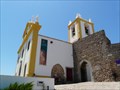 view gallery view galleryW15 km | Igreja de Santiago - Santiago do Cacém, Portugal in Património Português (Portuguese Heritage) The Church of Santiago, was declared as a National Monument on November 30th, 1922 posted by: tmob location: Setúbal, Portugal date approved: 02/10/2012 last visited: 03/16/2013 |
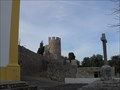 view gallery view galleryW15.1 km |  Castelo de Santiago do Cacém Castelo de Santiago do Cacém
in Castles A castle located in the town of Santiago do Cacém. posted by: Daniel C location: Setúbal, Portugal date approved: 04/26/2011 last visited: 03/16/2013 |
 view gallery view gallery SW15.6 km SW15.6 km
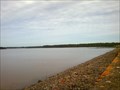
|  Barragem de Campilhas - Cercal do Alentejo, Portugal Barragem de Campilhas - Cercal do Alentejo, Portugal
in Water Dams Dam built in 1954 covering 109 km2
Barragem de 1954 ocupando uma área de 109 km2 posted by: MightyReek location: Setúbal, Portugal date approved: 11/13/2011 last visited: never |
 view gallery view gallerySE15.8 km | Carvalhal in Portugal Geodetic Points Carvalhal, N37º52.566 W008º23.904, Altitude 75 metros posted by: MightyReek location: Setúbal, Portugal date approved: 12/05/2011 last visited: never |
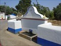
 view gallery view galleryNW17.4 km | ") Lavadouro de Santa Cruz Lavadouro de Santa Cruz
in Lavoir (wash houses) Lavadouro Público de Santa Cruz
Santa Cruz Public Lavoir posted by: MightyReek location: Setúbal, Portugal date approved: 10/02/2009 last visited: never |
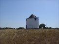 view gallery view gallery N18 km N18 km
|  Moinho de Santa Margarida da Serra/Grândola/Setúbal/Portugal Moinho de Santa Margarida da Serra/Grândola/Setúbal/Portugal
in Windmills This is one of many mills with more than 200 years that there are in the hills of Grândula. posted by: 100stress location: Setúbal, Portugal date approved: 04/11/2011 last visited: 11/28/2010 |
 view gallery view galleryN18 km |  Fonte de Santa Margarida da Serra/Grândola/Setubal/Portugal Fonte de Santa Margarida da Serra/Grândola/Setubal/Portugal
in Fountains "The fountain has never dried up even in very dry years"were the words spoken by the elders of the village. posted by: 100stress location: Setúbal, Portugal date approved: 04/11/2011 last visited: 11/28/2010 |
|