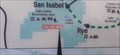
 view gallery view gallery NE9.8 km NE9.8 km
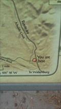
|   YOU ARE HERE! - Lake Isabel Recreation Area - San Isabel, CO YOU ARE HERE! - Lake Isabel Recreation Area - San Isabel, CO
in 'You Are Here' Maps Located at the North Shore Parking area of Lake Isabel. posted by:  mr.volkswagen mr.volkswagen location: Colorado date approved: 10/19/2021 last visited: never |
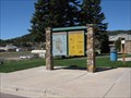
 view gallery view galleryNE10.1 km |  The Lodge Restaurant - San Isabel, CO The Lodge Restaurant - San Isabel, CO
in Neon Signs Located next to the Lodge. posted by: mr.volkswagen location: Colorado date approved: 03/17/2020 last visited: never |
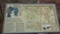
 view gallery view galleryNE10.8 km |  Teller County and Pikes Peak, Woodland Park, CO Teller County and Pikes Peak, Woodland Park, CO
in Colorado Historical Markers This sign, in Woodland Park, Colorado, provides the history of Pikes Peak and a map of Teller County. posted by: Queens Blessing location: Colorado date approved: 06/20/2010 last visited: 09/15/2012 |
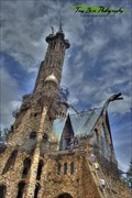 view gallery view galleryNE13.8 km |  Bishop Castle - Rye, CO Bishop Castle - Rye, CO
in Roadside Attractions Bishop Castle is a very popular Colorado roadside attraction. posted by: mr.volkswagen location: Colorado date approved: 08/19/2015 last visited: never |
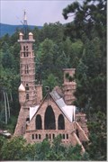 view gallery view galleryNE13.8 km |  Bishop Castle Bishop Castle
in Castles Bishop Castle is a one-man construction project by Jim Bishop. The castles contrustion was started in 1969 and is still in constant work. The castle reaches over 160 feet over the ground. posted by:  BobTheSpecialChild BobTheSpecialChild location: Colorado date approved: 10/28/2007 last visited: 07/18/2015 |
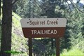 view gallery view galleryNE14.3 km |  Squirrel Creek Trailhead - Custer County, CO Squirrel Creek Trailhead - Custer County, CO
in Hiking and walking trailheads Trailhead is at the east end of the Davenport Campground. posted by: mr.volkswagen location: Colorado date approved: 09/24/2015 last visited: 07/13/2019 |
 view gallery view gallery SE16.7 km SE16.7 km
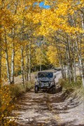
|  Medano Pass - Rio Grande National Forest - Colorado Medano Pass - Rio Grande National Forest - Colorado
in Offroad Trails Medano Pass is a great alternate route into or out of The Great Sand Dunes National Park posted by: mr.volkswagen location: Colorado date approved: 08/24/2017 last visited: 08/22/2017 |
 view gallery view gallery N16.9 km N16.9 km
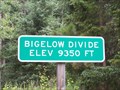
|  Bigelow Divide (9,350 ft.) Bigelow Divide (9,350 ft.)
in Elevation Signs Located on Highway 165 at the summit. posted by: mr.volkswagen location: Colorado date approved: 07/26/2009 last visited: 06/09/2013 |
 view gallery view gallery SW18.2 km SW18.2 km
| Lt. Zebulon Pike’s Southwestern Expedition - Huerfano County, CO in Colorado Historical Markers This historic marker is part of a series of markers that is commemorating Lt. Zebulon Pike’s southwestern expedition. posted by: mr.volkswagen location: Colorado date approved: 09/09/2015 last visited: never |
 view gallery view gallerySW18.2 km | YOU ARE HERE! - Huerfano County, CO in 'You Are Here' Maps On a history panel about LT. Zebulon Pike. posted by: mr.volkswagen location: Colorado date approved: 10/04/2016 last visited: never |
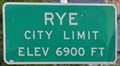 view gallery view gallery E20.1 km E20.1 km
| Rye, Colorado ~ Elevation 6900 Feet in Elevation Signs This Elevation Sign is located on the west side of Boulder Avenue the northern city limits of Rye, Colorado. posted by: brwhiz location: Colorado date approved: 04/02/2013 last visited: never |
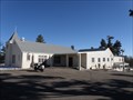
 view gallery view galleryE20.3 km |  Rye, Colorado 81069 Rye, Colorado 81069
in U.S. Post Offices This Post Office is located at 8084 State Highway 165 in Rye, Colorado. posted by: brwhiz location: Colorado date approved: 10/25/2011 last visited: never |
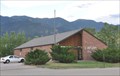
 view gallery view galleryE20.8 km |  St. Aloysius - Rye, CO St. Aloysius - Rye, CO
in Roman Catholic Churches A small church in Rye Colorado posted by: Gershon_ben_Franja location: Colorado date approved: 02/25/2010 last visited: never |
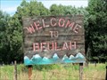 view gallery view galleryNE21.9 km |  Beulah, Colorado, USA Beulah, Colorado, USA
in Names From the Bible This small town had two prior names before settling on 'Beulah'. posted by: Outspoken1 location: Colorado date approved: 08/24/2015 last visited: never |
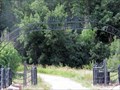 view gallery view galleryNE22 km |  Moore Ranch - Beulah, CO Moore Ranch - Beulah, CO
in Gates of Distinction These impressive gates are found just before one hits the junction of Hwy 78 (Colo) in Beulah, CO, USA. posted by: Outspoken1 location: Colorado date approved: 09/05/2015 last visited: never |
 view gallery view gallery NW23.3 km NW23.3 km
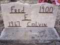
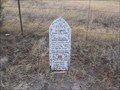
|  Fred F. Colvin - Rosita Cemetery - Rosita, CO Fred F. Colvin - Rosita Cemetery - Rosita, CO
in Homemade Tombstones The Rosita cemetery is located in the old mining town of Rosita just Southeast of Westcliffe, CO posted by: mr.volkswagen location: Colorado date approved: 05/28/2009 last visited: never |
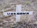 view gallery view galleryNW23.3 km |  Unknown - Rosita Cemetery - Rosita, CO Unknown - Rosita Cemetery - Rosita, CO
in Graves of the Unknown located in the Rosita Cemetery off Schoolfield Road posted by: mr.volkswagen location: Colorado date approved: 05/09/2009 last visited: never |
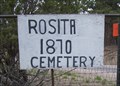 view gallery view galleryNW23.5 km |  Rosita Cemetery - Rosita, CO Rosita Cemetery - Rosita, CO
in Worldwide Cemeteries Just off Schoolfield Rd. posted by: mr.volkswagen location: Colorado date approved: 05/11/2009 last visited: never |
 view gallery view galleryNE26.2 km | Fisher's Hole - Beulah, Colorado in Colorado Historical Markers A marker noting the history of Robert Fisher and the formation of Fisher's Fort that later became Fort Pueblo. posted by: PersonsMD location: Colorado date approved: 11/01/2009 last visited: 08/08/2015 |
 view gallery view galleryNE26.2 km |  Beulah Time Capsule Beulah Time Capsule
in Time Capsules A time capsule buried in 2001 by the members of this small mountain town in Colorado. posted by: slate6715 location: Colorado date approved: 03/06/2008 last visited: 08/08/2015 |
 view gallery view galleryNE26.2 km |  The Solid Muldoon The Solid Muldoon
in Weird Story Locations Memorial for the Solid Muldoon of Beulah fame. posted by: slate6715 location: Colorado date approved: 03/17/2008 last visited: 08/08/2015 |
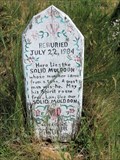 view gallery view galleryNE26.2 km | Roadside Grave of Solid Muldoon - Beulah, CO in Roadside Attractions Proof the American public is as gullible then as now. posted by: Outspoken1 location: Colorado date approved: 04/03/2018 last visited: never |
 view gallery view galleryNE26.2 km | Goodpasture, Colorado - Beulah, CO in Colorado Historical Markers This is a newer marker highlighting the early community of Goodpasture, Colorado. posted by: Outspoken1 location: Colorado date approved: 08/09/2015 last visited: never |
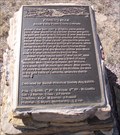
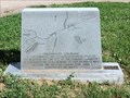
 view gallery view galleryNE26.2 km |  Civil War Conflict in Colorado - near Beulah, CO Civil War Conflict in Colorado - near Beulah, CO
in U.S. Civil War Sites Colorado was a territory during the Civil War, but there were credible attempts by Confederate forces to capture the gold fields for revenue and create a western land route for supplies. posted by: Outspoken1 location: Colorado date approved: 08/09/2015 last visited: never |
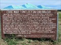
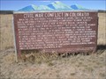 view gallery view galleryNE26.2 km | Civil War Conflict In Colorado in Colorado Historical Markers A marker placed in 1971 noting the role Colorado played in the Civil War of the United States. Located near Pueblo and Beulah, Colorado. Marker was reloacated in 1996. posted by: PersonsMD location: Colorado date approved: 10/28/2009 last visited: 08/08/2015 |
|