 view gallery view gallery SE21.9 km SE21.9 km
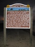
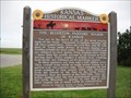
|   GREENWOOD COUNTY & THE BLUESTEM PASTURE REGION GREENWOOD COUNTY & THE BLUESTEM PASTURE REGION
in Kansas Historical Markers GREENWOOD COUNTY AND THE BLUESTEM PASTURE REGION OF KANSAS posted by:  GEO*Trailblazer 1 GEO*Trailblazer 1 location: Kansas date approved: 04/06/2008 last visited: 05/11/2010 |
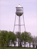 view gallery view gallerySE26.2 km |  Toronto Kansas Water Tower Toronto Kansas Water Tower
in Water Towers Another of the "Tin Mans hat" topped water towers that dot the Kansas countryside. posted by: SafireLady location: Kansas date approved: 05/08/2008 last visited: never |
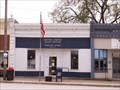 view gallery view gallerySE26.9 km |  Toronto, Kansas 66777 Toronto, Kansas 66777
in U.S. Post Offices Toronto is a city in Woodson County, Kansas, along the Verdigris River. The population was 312 at the 2000 census posted by: SafireLady location: Kansas date approved: 05/06/2008 last visited: never |
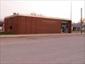 view gallery view gallery S34 km S34 km
| Severy, Kansas 67134 in U.S. Post Offices This Post Office sits on the corner of Main and Greenwood streets in Severy, Kansas. posted by: SafireLady location: Kansas date approved: 04/17/2008 last visited: 03/26/2009 |
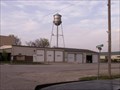
 view gallery view galleryS34 km | Severy Kansas Water Tower in Water Towers This water tower is located in the downtown area of Severy, Kansas. posted by: SafireLady location: Kansas date approved: 04/17/2008 last visited: never |
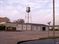
 view gallery view galleryS34 km |  Severy Fire Dept Severy Fire Dept
in Firehouses Severy, Fire Dept. building. Located on main Street, downtown Severy, Kansas. posted by: SafireLady location: Kansas date approved: 04/18/2008 last visited: never |
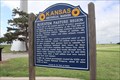
 view gallery view gallery NW37.5 km NW37.5 km
| The Bluestem Pasture Region of Kansas - Rural Butler County, Ks. in Kansas Historical Markers This marker is in the Matfield Green Rest Area at Milepost 96 along the Kansas Turnpike in rural Butler County, Kansas. posted by:  iconions iconions location: Kansas date approved: 07/10/2011 last visited: 04/29/2022 |
 view gallery view galleryNW37.5 km |  The Bluestem Pasture Region of KS -- Matfield Green KTA Service Area, Towanda KS The Bluestem Pasture Region of KS -- Matfield Green KTA Service Area, Towanda KS
in Flora and Fauna Information Signs A flora and fauna information sign at the Matfield Green KTA Service Area, Towanda KS posted by: Benchmark Blasterz location: Kansas date approved: 11/28/2017 last visited: 04/29/2022 |
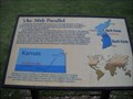 view gallery view galleryNW37.5 km |  38th Parallel - Matfield Green Rest Area - Rural Butler County, Ks. 38th Parallel - Matfield Green Rest Area - Rural Butler County, Ks.
in Korean War Memorials This historical marker in the Matfield Green Rest Area describes the 38th parallel going through Kansas and Korea. It then also describes the Korean Conflict and the Kansas National Guard Units mobilized. posted by: iconions location: Kansas date approved: 07/09/2011 last visited: 04/29/2022 |
 view gallery view galleryNW37.5 km |  Al Larsen - Matfield Green Rest Area - Rural Chase County, Ks. Al Larsen - Matfield Green Rest Area - Rural Chase County, Ks.
in Citizen Memorials This very moving memorial is located north of the service area in the Matfield Green Service Area at Mile Post 96 on the Kansas Turnpike. posted by: iconions location: Kansas date approved: 07/09/2011 last visited: 04/29/2022 |
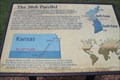 view gallery view galleryNW37.5 km |  38th Parallel -- KTA Service Area, Towanda KS 38th Parallel -- KTA Service Area, Towanda KS
in Great Lines of Earth A sign at the KTA Service Area, Towanda KS near the 38th parallel of Earth, which passes near here. The 38th parallel is important because it is the border between North and South Korea posted by: Benchmark Blasterz location: Kansas date approved: 11/28/2017 last visited: 04/29/2022 |
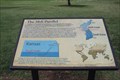 view gallery view galleryNW37.5 km | 38th Parallel -- Matfield Green KTA Service Area, Towanda KS in Kansas Historical Markers A sign at the KTA Matfield Green Service Area near the 38th parallel of Earth, which passes near here, memorializes the Korean War and the Kansas ARNG units that were delpoyed to fight there posted by: Benchmark Blasterz location: Kansas date approved: 11/27/2017 last visited: 04/29/2022 |
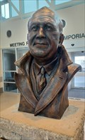 view gallery view galleryNW37.5 km |  Knute Rockne - Matfield Green, KS Knute Rockne - Matfield Green, KS
in Statues of Historic Figures This bust of Knute Rockne is at the center of the Manfield Green Service Area - near Manfield Green, Kansas. posted by: The Snowdog location: Kansas date approved: 04/28/2022 last visited: never |
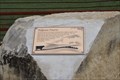 view gallery view galleryNW38.1 km | Tallgrass Prairie -- KTA scenic pull-out, southwest of Emporia, KS in Flora and Fauna Information Signs This flora and fauna sign is located in the scenic pullout along the KTA southwest of Emporia KS posted by: Benchmark Blasterz location: Kansas date approved: 11/29/2017 last visited: 08/21/2017 |
 view gallery view galleryNW38.1 km |  Flint Hills Scenic Pull-out -- KTA MM 111, SW of Emporia KS Flint Hills Scenic Pull-out -- KTA MM 111, SW of Emporia KS
in Scenic Roadside Look-Outs A beautiful spot to see the Tallgrass Prairie from the scenic pullout along the KTA at mile marker 111 southwest of Emporia KS posted by: Benchmark Blasterz location: Kansas date approved: 12/09/2017 last visited: 08/20/2017 |
 view gallery view galleryNW38.1 km | Tallgrass Prairie -- KTA scenic pull-out, southwest of Emporia, KS in Kansas Historical Markers This marker is located in the scenic pullout alomg the KTA southwest of Emporia KS posted by: Benchmark Blasterz location: Kansas date approved: 11/29/2017 last visited: 08/21/2017 |
 view gallery view gallery SW39.9 km SW39.9 km
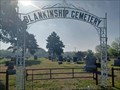
|  Blankenship Cemetery - Rosalia, KS Blankenship Cemetery - Rosalia, KS
in Worldwide Cemeteries This small cemetery is in northeast Butler County, a few miles south of Rosalia, Kansas. posted by: The Snowdog location: Kansas date approved: 05/11/2023 last visited: never |
 view gallery view gallerySW39.9 km | Butler County Fural Fire District #5 in Firehouses This small firehouse is on the west side of Flint Hills Road, a few miles south of Rosalita, Kansas. posted by: The Snowdog location: Kansas date approved: 05/11/2023 last visited: never |
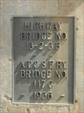 view gallery view galleryNW40.1 km |  Highway/A.T.&S.F. Ry. Bridge - 1936 ~ Matfield Green KS Highway/A.T.&S.F. Ry. Bridge - 1936 ~ Matfield Green KS
in Bridge Date Stones and Plaques This Bridge Date Plaque is on A.T & S.F.RY. Bridge No. 147 C that crosses Kansas Highway 177, 3.25 miles south of Matfield Green, Kansas. posted by: PeterNoG location: Kansas date approved: 06/18/2014 last visited: 03/03/2011 |
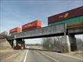 view gallery view galleryNW40.1 km |  A.T.&S.F. Ry. Bridge - Matfield Green KS A.T.&S.F. Ry. Bridge - Matfield Green KS
in Railroad Bridges This Railroad Bridge is A.T & S.F.RY. Bridge No. 147 C that crosses Kansas Highway 177, 3.25 miles south of Matfield Green, Kansas. posted by: PeterNoG location: Kansas date approved: 06/18/2014 last visited: 03/03/2011 |
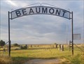 view gallery view gallerySW40.2 km | Beaumont Cemetery - Beaumont, KS in Worldwide Cemeteries Beaumont Cemetery is north of Highway 400 - near Beaumont, Kansas. posted by: The Snowdog location: Kansas date approved: 09/17/2023 last visited: never |
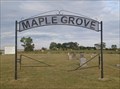 view gallery view gallerySW40.7 km | Maple Grove Cemetery - Beaumont, KS in Worldwide Cemeteries Maple Grove Cemetery is just north of Beaumont, Kansas. posted by: The Snowdog location: Kansas date approved: 09/17/2023 last visited: never |
 view gallery view gallery E41.4 km E41.4 km
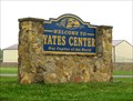
|  Yates Center, Hay Capital of the World, Kansas Yates Center, Hay Capital of the World, Kansas
in Welcome Signs Yates Center, Kansas is a town that boasts being the "Hay Capital of the World!" posted by: Queens Blessing location: Kansas date approved: 05/30/2010 last visited: 05/31/2017 |
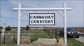 view gallery view gallery W41.4 km W41.4 km
| Cassoday Cemetery - Cassoday, KS in Worldwide Cemeteries Cassoday Cemetery is about a mile west of Cassoday, Kansas. posted by: The Snowdog location: Kansas date approved: 04/24/2023 last visited: never |
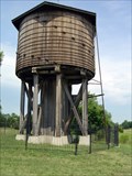 view gallery view gallerySW41.4 km |  Beaumont St. Louis and San Francisco Railroad Water Tank Beaumont St. Louis and San Francisco Railroad Water Tank
in U.S. National Register of Historic Places 1885 Frisco wooden water tower. posted by: wardnkathy location: Kansas date approved: 06/12/2006 last visited: 11/10/2019 |
|