 view gallery view gallery S14.3 km S14.3 km
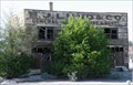
|   B. J. LUND Co. ... ... HOTEL - Modena, Utah B. J. LUND Co. ... ... HOTEL - Modena, Utah
in Ghost Signs Old building in Modena Utah. posted by:  nvtriker nvtriker location: Utah date approved: 05/26/2009 last visited: never |
 view gallery view gallery NW23.7 km NW23.7 km
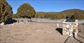
|  Spring Valley Cemetery - State Line Canyon, Pioche, NV Spring Valley Cemetery - State Line Canyon, Pioche, NV
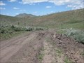
in Abandoned Cemeteries A small cemetery with few surviving headstones in the BLM Ely district near Pioche. There are 15 graves listed. posted by: ChapterhouseInc location: Nevada date approved: 03/08/2012 last visited: 08/07/2011 |
 view gallery view galleryNW23.7 km |  Spring Valley Cemetery - State Line Canyon, Pioche, NV Spring Valley Cemetery - State Line Canyon, Pioche, NV
in Worldwide Cemeteries A small cemetery with few surviving headstones in the BLM Ely district near Pioche. There are 15 graves listed. posted by: ChapterhouseInc location: Nevada date approved: 03/13/2012 last visited: 08/07/2011 |
 view gallery view galleryS24.1 km |  Utah Nevada Highway 56 Utah Nevada Highway 56
in Border Crossings Border Crossing on highway 56 posted by:  caverspencer caverspencer location: Utah date approved: 02/25/2007 last visited: 05/29/2014 |
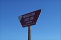
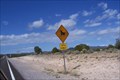 view gallery view gallery SW24.3 km SW24.3 km
|  Bull? Crossing Hwy 56 West of UT/NV stateline Bull? Crossing Hwy 56 West of UT/NV stateline
in Uncommon Crossing Signs Bull? Crossing...I've seen lots of cattle crossing signs. Just never seen a BULL crossing. Even has a lasso around it's neck. posted by: PeanutsParents location: Nevada date approved: 09/30/2007 last visited: 04/01/2021 |
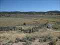
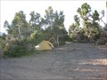
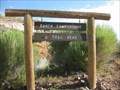 view gallery view galleryNW24.3 km |  Ranch Campground and Trailhead - Spring Valley State Park Ranch Campground and Trailhead - Spring Valley State Park
in Campgrounds A smaller campground north of the main campground at Spring Valley State Park. posted by: ChapterhouseInc location: Nevada date approved: 08/31/2011 last visited: 07/24/2011 |
 view gallery view gallery W24.8 km W24.8 km
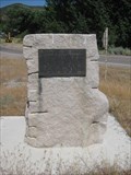
|  Eagle Valley Fort Eagle Valley Fort
in Nevada Historical Markers An old marker notating Brigham Youngs directive to settle this valley. posted by: ChapterhouseInc location: Nevada date approved: 05/03/2012 last visited: 08/07/2011 |
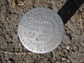
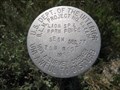
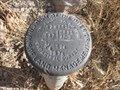 view gallery view galleryNW24.8 km |  T2NR69E - USDOI BLM T2NR69E - USDOI BLM
in U.S. Benchmarks Set in a pulloff for Spring Lake State Park. posted by: ChapterhouseInc location: Nevada date approved: 08/11/2011 last visited: 08/07/2011 |
 view gallery view galleryS25.3 km | Nevada / Utah Border Crossing ( Uvada dirt road ) in Border Crossings Along a dirt road that turns south from highway 56 West of Uvada, UT.
posted by: PeanutsParents location: Utah date approved: 10/15/2007 last visited: 05/29/2014 |
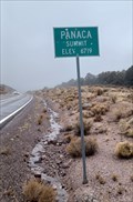 view gallery view gallerySW27.8 km |  6719 Feet - Panaca Summit - Lincoln County, NV 6719 Feet - Panaca Summit - Lincoln County, NV
in Elevation Signs This elevation sign is on the west side of Highway 319 - in Lincoln County, Nevada. posted by: The Snowdog location: Nevada date approved: 01/02/2023 last visited: never |
 view gallery view gallery SE35.6 km SE35.6 km
|  Pioneer Park - Beryl Junction, UT Pioneer Park - Beryl Junction, UT
in Municipal Parks and Plazas This modest park contains little other than a shelter and a monument - in Beryl Junction, Utah. posted by: The Snowdog location: Utah date approved: 01/01/2023 last visited: never |
 view gallery view galleryNW37.3 km | Parsnip Pipeline - USDOI in U.S. Benchmarks One of two benchmarks set and the end of this wilderness access road. posted by: ChapterhouseInc location: Nevada date approved: 08/11/2011 last visited: 07/19/2011 |
 view gallery view galleryNW37.3 km | Parsnip Fire Rehab - USDOI BLM in U.S. Benchmarks One of two benchmarks set and the end of this wilderness access road. posted by: ChapterhouseInc location: Nevada date approved: 08/11/2011 last visited: 07/19/2011 |
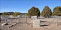
 view gallery view galleryS38.8 km | Hebron Cemetery in Worldwide Cemeteries This Cemetery is located a short distance north of Utah Highway 219, on the north side of Shoal Creek, about 7 miles west of Enterprise, Utah. posted by: brwhiz location: Utah date approved: 04/18/2013 last visited: never |
 view gallery view galleryS38.8 km |  Hebron: Pioneer Settlement on Shoal Creek ~ Hebron, Utah, USA Hebron: Pioneer Settlement on Shoal Creek ~ Hebron, Utah, USA
in Human Migration Monuments The pioneers of Hebron migrated 50 miles north from St. George in search of better grazing for their cattle. Almost 50 years later they again migrated 7 miles east to the new settlement of Enterprise. posted by: brwhiz location: Utah date approved: 04/16/2013 last visited: never |
 view gallery view galleryS38.8 km |  Hebron: Pioneer Settlement on Shoal Creek Hebron: Pioneer Settlement on Shoal Creek
in Ghost Towns The pioneer cemetery is all that remains of the small rural agricultural community of Hebron, about 7 miles west of Enterprise, Utah. posted by: brwhiz location: Utah date approved: 04/16/2013 last visited: never |
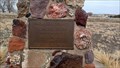
 view gallery view galleryS38.8 km |  Hebron: Pioneer Settlement on Shoal Creek Hebron: Pioneer Settlement on Shoal Creek
in Utah Historical Markers This Historical Marker is mounted on a concrete slab on top of a rock monument just inside the cemetery entrance at the ghost town of Hebron, about 7 miles west of Enterprise, Utah. posted by: brwhiz location: Utah date approved: 04/16/2013 last visited: never |
 view gallery view galleryNW39.9 km | White Rock Range Wilderness Camping Areas - NV in Free Campsites There are several assorted camping areas scattered around the White Rock Mountain Wilderness. posted by: ChapterhouseInc location: Nevada date approved: 08/14/2011 last visited: 06/14/2011 |
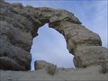 view gallery view galleryW40.2 km |  "Teapot" Arch near Panaca, NV "Teapot" Arch near Panaca, NV
in Natural Arches Nice arch near the town of Panaca in Eastern Nevada posted by:  Uncle Alaska Uncle Alaska location: Nevada date approved: 11/23/2005 last visited: 05/29/2014 |
 view gallery view galleryNW40.4 km | Lion Spring - White Rock Mountain Wilderness Area in U.S. Benchmarks A benchmark set near the southwest corner protecting the fence. posted by: ChapterhouseInc location: Nevada date approved: 06/19/2011 last visited: 06/14/2011 |
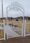 view gallery view galleryW40.6 km | Panaca Memorial Park - Panaca, NV in Worldwide Cemeteries Panaca Memorial Park is on the northeast side of Panaca, Nevada. posted by: The Snowdog location: Nevada date approved: 01/01/2023 last visited: never |
 view gallery view gallery N40.6 km N40.6 km
|  White Rock Range Wilderness - NV White Rock Range Wilderness - NV
in Public Access Lands The White Rock Mountain Wilderness provides access to hiking, hunting, off roading (ATV/UTV) and wildlife viewing. posted by: ChapterhouseInc location: Nevada date approved: 06/20/2011 last visited: 06/15/2011 |
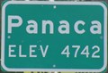 view gallery view galleryW41 km | Panaca Elev 4742 - Panaca, Nevada in Elevation Signs A town on Nevada State Route 319. posted by: nvtriker location: Nevada date approved: 05/18/2009 last visited: 09/10/2013 |
 view gallery view galleryW41 km | Panaca Spring in Nevada Historical Markers Nevada State Historical Marker No. 160 is located in the park on the north side of the junction of Panaca Spring Road and Ernst Street. posted by: brwhiz location: Nevada date approved: 09/13/2012 last visited: never |
 view gallery view galleryW41.2 km |  CINDY-SOOZ Country Kitchen - Panaca, NV CINDY-SOOZ Country Kitchen - Panaca, NV
in Independent Diners An independent dining establishment in Panaca, Nevada. posted by: nvtriker location: Nevada date approved: 05/18/2009 last visited: never |
|