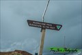
 view gallery view gallery NE2.6 km NE2.6 km
|   Hurricane Pass, CO (12,730 ft.) Hurricane Pass, CO (12,730 ft.)
in Elevation Signs Hurricane Pass is located in the San Juan Mountains of Colorado. posted by:  mr.volkswagen mr.volkswagen location: Colorado date approved: 08/06/2018 last visited: 08/06/2018 |
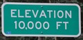 view gallery view gallery NW5.1 km NW5.1 km
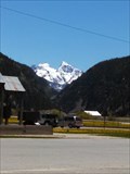
| Million Dollar Highway ~ Elevation 10,000 Feet in Elevation Signs This Elevation Sign is located on the northwest side of the Million Dollar Highway (US Highway 550) about 8.7 miles south of Ouray, Colorado. posted by: brwhiz location: Colorado date approved: 02/15/2013 last visited: 09/14/2014 |
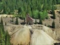 view gallery view gallery W5.5 km W5.5 km
|  Idarado Mine mysteries - Ouray county - Colorado Idarado Mine mysteries - Ouray county - Colorado
in News Article Locations Idarado Mine mysteries; Saturday open house to highlight history posted by: gemeloj location: Colorado date approved: 12/20/2019 last visited: never |
 view gallery view galleryW5.5 km |  The Idarado Mine - Ouray county, Colorado The Idarado Mine - Ouray county, Colorado
in Mines The Idarado Mine is a lead mine located in Ouray county, Colorado at an elevation of 10,499 feet. posted by: gemeloj location: Colorado date approved: 12/20/2019 last visited: never |
 view gallery view galleryW5.5 km |  Idarado Mine - Ouray County - Colorado Idarado Mine - Ouray County - Colorado
in Wikipedia Entries The Idarado Mine was a mining operation in the San Juan Mountains posted by: gemeloj location: Colorado date approved: 12/20/2019 last visited: never |
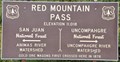
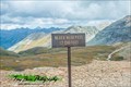
 view gallery view galleryW6.1 km | Red Mountain Pass ~ Elevation 11,018 Feet in Elevation Signs This Elevation Sign is at the summit of Red Mountain Pass on US Highway 550 between Ouray and Silverton, Colorado. posted by: brwhiz location: Colorado date approved: 04/27/2013 last visited: 09/01/2019 |
 view gallery view galleryW6.1 km | Red Mountain Pass ~ Elevation 11,018 Feet in Elevation Signs This Elevation Sign is at the summit of Red Mountain Pass on US Highway 550 between Ouray and Silverton, Colorado. posted by: brwhiz location: Colorado date approved: 04/27/2013 last visited: 07/14/2015 |
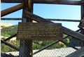
 view gallery view gallery SW7.4 km SW7.4 km
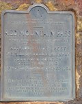
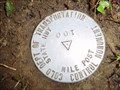
|  Colo DOT MilePost 100 Colo DOT MilePost 100
in U.S. Benchmarks Metal disk mounted in the ground. Colo Department of Transportation Control Monument, State Hwy Mile Post 100.
Located at the base of Niagara Gulch along the abandon RR bed from Silverton to Gladstone. 2.5 miles up Cement Creek from HL0284.
posted by:  Ag2000CO Ag2000CO location: Colorado date approved: 09/07/2009 last visited: never |
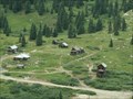
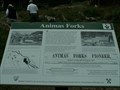
 view gallery view galleryNE7.6 km |  Animas Forks, Colorado Animas Forks, Colorado
in Ghost Towns "Three Forks of the Animus" as it was once called, was a prosperous mining town, is now a ghost town visited by 100,000 visitors a year. posted by: 94RedRover location: Colorado date approved: 02/01/2009 last visited: 10/03/2021 |
 view gallery view galleryNE7.6 km | Animas Forks, Colorado in Wikipedia Entries "Three Forks of the Animus" as it was once called, was a prosperous mining town, is now a ghost town visited by 100,000 visitors a year. posted by: 94RedRover location: Colorado date approved: 01/31/2009 last visited: 10/03/2021 |
 view gallery view galleryNE7.6 km |  San Juan Skyway - Animas Forks, CO San Juan Skyway - Animas Forks, CO
in National Scenic Byways Day two, stop two of the San Juan Skyway Must See Scenic Byway are the ghost towns outside of Silverton, Colorado. posted by: 94RedRover location: Colorado date approved: 01/31/2009 last visited: 10/03/2021 |
 view gallery view galleryNE7.6 km |  Animas Forks, Colorado Animas Forks, Colorado
in Signs of History "Three Forks of the Animus" as it was once called, was a prosperous mining town, is now a ghost town visited by 100,000 visitors a year. posted by: 94RedRover location: Colorado date approved: 01/31/2009 last visited: 10/03/2021 |
 view gallery view gallery SE8 km SE8 km
|  International Scout - San Juan County, CO International Scout - San Juan County, CO
in Abandoned Dead Vehicles Located in San Juan County just off of Animas Forks Rd. posted by: mr.volkswagen location: Colorado date approved: 08/04/2015 last visited: never |
 view gallery view galleryW8.9 km | Black Bear Pass, CO (12, 840 ft.) in Elevation Signs Black Bear Pass is located in the San Juan Mountains of Colorado. posted by: mr.volkswagen location: Colorado date approved: 08/06/2018 last visited: 08/06/2018 |
 view gallery view gallery S9.7 km S9.7 km
|  Silvertown Co museum Silvertown Co museum
in History Museums Silvertown nuseum posted by: kingbee location: Colorado date approved: 06/10/2015 last visited: 07/08/2023 |
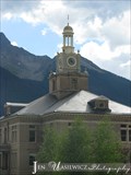 view gallery view galleryS9.7 km |  Courthouse Clock - Silverton, CO Courthouse Clock - Silverton, CO
in Town Clocks This clock is located on top of the San Juan county Courthouse building in Silverton, CO. posted by: ArmyFamily4 location: Colorado date approved: 04/07/2011 last visited: 07/08/2023 |
 view gallery view gallery E9.8 km E9.8 km
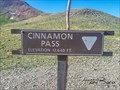
| Cinnamon Pass, CO (12,640 ft.) in Elevation Signs Cinnamon Pass is located in the San Juan Mountians. posted by: mr.volkswagen location: Colorado date approved: 08/06/2018 last visited: 08/06/2018 |
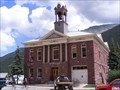 view gallery view galleryS9.8 km |  Silverton, CO Silverton, CO
in City and Town Halls Silverton is a National Historic Landmark, part of the San Juan Skyway (with the Million Dollar Highway connecting Silverton to Ouray), and the summer destination for the Durango & Silverton Narrow Gauge Railroad train ride. posted by: Don.Morfe location: Colorado date approved: 12/08/2020 last visited: 07/08/2023 |
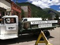 view gallery view galleryS10 km |  Silverton Brewery, Silverton, CO Silverton Brewery, Silverton, CO
in Brewpubs "PURE AS THE WATERS THAT FLOW DOWN THESE MOUNTAINS". posted by: Avgirls33 location: Colorado date approved: 01/07/2012 last visited: never |
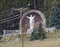 view gallery view galleryS10 km |  Christ of the Mines - Silverton CO Christ of the Mines - Silverton CO
in Roadside Attractions A 12-ton, 16-foot tall statue of Jesus Christ, sits some 500 feet up the slope of Anvil Mountain, north of the town of Silverton. posted by: Don.Morfe location: Colorado date approved: 01/18/2022 last visited: 01/18/2022 |
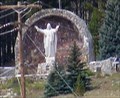 view gallery view galleryS10 km |  Christ of the Mines - Silverton CO Christ of the Mines - Silverton CO
in Statues of Religious Figures A 12-ton, 16-foot tall statue of Jesus Christ, sits some 500 feet up the slope of Anvil Mountain, north of the town of Silverton. posted by: Don.Morfe location: Colorado date approved: 01/18/2022 last visited: 01/18/2022 |
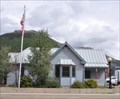 view gallery view galleryS10 km |  Silverton, Colorado 81433 Silverton, Colorado 81433
in U.S. Post Offices This Post Office is located at 138 W 12th Street in Silverton, Colorado. posted by: brwhiz location: Colorado date approved: 10/31/2011 last visited: never |
 view gallery view galleryS10.1 km |  The Lookout Shop Penny Smasher The Lookout Shop Penny Smasher
in Penny Smashers This three-design Penny Smasher is in front of The Lookout Shop at 1215 Blair Street in Silverton, Colorado. posted by: brwhiz location: Colorado date approved: 10/22/2011 last visited: never |
 view gallery view galleryS10.1 km | K & C Traders Penny Smasher #1 in Penny Smashers This is one of two three-design Penny Smashers in front of K & C Traders at 1152 Greene Street in Silverton, Colorado. posted by: brwhiz location: Colorado date approved: 10/22/2011 last visited: never |
 view gallery view galleryS10.1 km | K & C Traders Penny Smasher #2 in Penny Smashers This is the second of two three-design Penny Smashers in front of K & C Traders at 1152 Greene Street in Silverton, Colorado. posted by: brwhiz location: Colorado date approved: 10/22/2011 last visited: never |
|