 view gallery view gallery N3.7 km N3.7 km
|   Rye, Colorado 81069 Rye, Colorado 81069
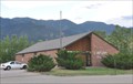
in U.S. Post Offices This Post Office is located at 8084 State Highway 165 in Rye, Colorado. posted by:  brwhiz brwhiz location: Colorado date approved: 10/25/2011 last visited: never |
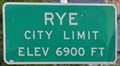 view gallery view galleryN3.7 km |  Rye, Colorado ~ Elevation 6900 Feet Rye, Colorado ~ Elevation 6900 Feet
in Elevation Signs This Elevation Sign is located on the west side of Boulder Avenue the northern city limits of Rye, Colorado. posted by: brwhiz location: Colorado date approved: 04/02/2013 last visited: never |
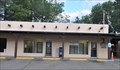
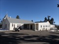 view gallery view galleryN3.7 km |  St. Aloysius - Rye, CO St. Aloysius - Rye, CO
in Roman Catholic Churches A small church in Rye Colorado posted by:  Gershon_ben_Franja Gershon_ben_Franja location: Colorado date approved: 02/25/2010 last visited: never |
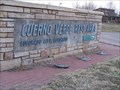
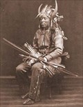 view gallery view gallery NE9.2 km NE9.2 km
|  Chief Cuerno Verde - Colorado City, CO Chief Cuerno Verde - Colorado City, CO
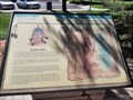
in Colorado Historical Markers This historical event, that happened over 200 years ago, is about where Juan Bautista de Anza, then Governor of New Mexico, marched, camped and fought the feared Comanche Chief Cuerno Verde (Greenhorn) on September 3, 1779, just eighteen miles south of Pueblo, Colorado. Cuerno Verde and several of his warriors were killed, an event which literally changed the course of history in what is now Colorado. posted by: beagle39z location: Colorado date approved: 06/03/2009 last visited: never |
 view gallery view galleryNE10.5 km | Colorado City, Colorado 81019 in U.S. Post Offices This Post Office is located at 4490 Bent Brothers Blvd in Colorado City, Colorado. posted by: brwhiz location: Colorado date approved: 10/25/2011 last visited: never |
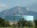 view gallery view galleryNE10.8 km |  WALSENBURG - Water Tank WALSENBURG - Water Tank
in Water Towers WALSENBURG,Colorado Filter Plant Tank posted by: GEO*Trailblazer 1 location: Colorado date approved: 01/23/2007 last visited: 01/23/2007 |
 view gallery view gallery NW14.2 km NW14.2 km
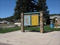
|  YOU ARE HERE! - Lake Isabel Recreation Area - San Isabel CO YOU ARE HERE! - Lake Isabel Recreation Area - San Isabel CO
in 'You Are Here' Maps Located at the south entrance to Lake Isabel just past the gate on the right. posted by: mr.volkswagen location: Colorado date approved: 08/12/2024 last visited: never |
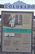
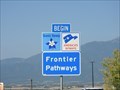 view gallery view galleryNE14.3 km |  Frontier Pathways - Huerfano County, CO Frontier Pathways - Huerfano County, CO
in National Scenic Byways This byway is in Southeast Colorado, a often overlooked part of the state. posted by: Outspoken1 location: Colorado date approved: 02/09/2019 last visited: never |
 view gallery view galleryNE14.5 km |  Cuerno Verde Rest Area - Colorado City, CO Cuerno Verde Rest Area - Colorado City, CO
in Highway Rest Areas Great Place to get out and stretch the legs. posted by: mr.volkswagen location: Colorado date approved: 03/28/2008 last visited: 03/17/2020 |
 view gallery view galleryNE14.5 km | Cuerno Verde - Colorado City, CO in Colorado Historical Markers Located in the Cuerno Verde Rest Area in Colorado City, CO at exit 74 of Intersate 25. posted by: mr.volkswagen location: Colorado date approved: 09/27/2022 last visited: never |
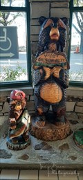 view gallery view galleryNE14.5 km |  Two Bears - Cuerno Verde Rest Area - Colorado City, CO Two Bears - Cuerno Verde Rest Area - Colorado City, CO
in Bear Statues Located at the Cuerno Verde Rest Area in Colorado City, Colorado, just off Interstate 25 Exit 74. posted by: mr.volkswagen location: Colorado date approved: 11/01/2021 last visited: never |
 view gallery view galleryNW15 km | YOU ARE HERE! - Lake Isabel Recreation Area - San Isabel, CO in 'You Are Here' Maps Located at the North Shore Parking area of Lake Isabel. posted by: mr.volkswagen location: Colorado date approved: 10/19/2021 last visited: never |
 view gallery view galleryNW15.1 km |  The Lodge Restaurant - San Isabel, CO The Lodge Restaurant - San Isabel, CO
in Neon Signs Located next to the Lodge. posted by: mr.volkswagen location: Colorado date approved: 03/17/2020 last visited: never |
 view gallery view galleryNW16.1 km | Teller County and Pikes Peak, Woodland Park, CO in Colorado Historical Markers This sign, in Woodland Park, Colorado, provides the history of Pikes Peak and a map of Teller County. posted by: Queens Blessing location: Colorado date approved: 06/20/2010 last visited: 09/15/2012 |
 view gallery view gallery SE17.9 km SE17.9 km
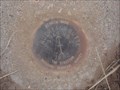
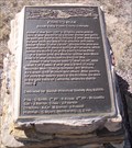
|  Huerfano Butte - Walsenburg, CO Huerfano Butte - Walsenburg, CO
in Azimuth Benchmarks Marker: Dz = Azimuth Mark Disk
Setting: 7 = Set In Top Of Concrete Monument
Stamping: Huerfano Butte No 2 1949 1982
Magnetic: N = No Magnetic Material
Stability: C = May Hold, But Of Type Commonly Subject To Surface Motion posted by: beagle39z location: Colorado date approved: 06/21/2009 last visited: 07/31/2018 |
 view gallery view gallerySE18 km | Huerfano Butte in Colorado Historical Markers Located on Interstate 25 North Bound. posted by: mr.volkswagen location: Colorado date approved: 11/30/2007 last visited: 03/19/2022 |
 view gallery view gallerySE18 km | You are on Huerfano Butte, Colorado in 'You Are Here' Maps Huerfano Butte can be seen from miles away. You will need to watch for this sign or you will miss it! posted by: Queens Blessing location: Colorado date approved: 06/13/2010 last visited: 07/30/2020 |
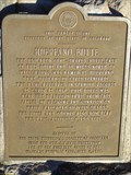
 view gallery view gallerySE18 km | Huerfano Butte - Beacon to Settlement - Huerfano County, Colorado in Colorado Historical Markers This Colorado Historical Marker is located in a turnout on the east side of Interstate Highway 25/US Highway 87 at milepost 59 north of Walsenburg, Colorado. posted by: brwhiz location: Colorado date approved: 03/09/2013 last visited: 07/30/2020 |
 view gallery view gallerySE18 km | Huerfano Butte, Beacon to Settlement - Huerfano Cty, CO in Colorado Historical Markers This marker is only accessible from the northbound side of I-25 (unless you drive past and make a loop back). Ample parking. posted by: Outspoken1 location: Colorado date approved: 08/04/2018 last visited: 07/30/2020 |
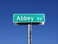 view gallery view galleryNE19 km |  Abbey Road - Colorado City, CO Abbey Road - Colorado City, CO
in Beatlemania! Abbey Road is a stretch of road that runs about 6.4 miles from rural Colorado into Colorado City. This sign is at the interchange where the road crosses I-25. posted by: QuarrellaDeVil location: Colorado date approved: 10/31/2021 last visited: never |
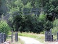 view gallery view galleryN20 km |  Moore Ranch - Beulah, CO Moore Ranch - Beulah, CO
in Gates of Distinction These impressive gates are found just before one hits the junction of Hwy 78 (Colo) in Beulah, CO, USA. posted by: Outspoken1 location: Colorado date approved: 09/05/2015 last visited: never |
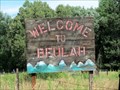 view gallery view galleryN20.3 km |  Beulah, Colorado, USA Beulah, Colorado, USA
in Names From the Bible This small town had two prior names before settling on 'Beulah'. posted by: Outspoken1 location: Colorado date approved: 08/24/2015 last visited: never |
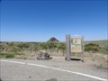
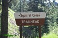 view gallery view galleryNW21.7 km |  Squirrel Creek Trailhead - Custer County, CO Squirrel Creek Trailhead - Custer County, CO
in Hiking and walking trailheads Trailhead is at the east end of the Davenport Campground. posted by: mr.volkswagen location: Colorado date approved: 09/24/2015 last visited: 07/13/2019 |
 view gallery view galleryN22.4 km | Fisher's Hole - Beulah, Colorado in Colorado Historical Markers A marker noting the history of Robert Fisher and the formation of Fisher's Fort that later became Fort Pueblo. posted by: PersonsMD location: Colorado date approved: 11/01/2009 last visited: 08/08/2015 |
 view gallery view galleryN22.4 km |  Beulah Time Capsule Beulah Time Capsule
in Time Capsules A time capsule buried in 2001 by the members of this small mountain town in Colorado. posted by: slate6715 location: Colorado date approved: 03/06/2008 last visited: 08/08/2015 |
|