 view gallery view gallery NW2.3 km NW2.3 km
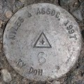
|   KYDOH M-2, Jessamine County, KY KYDOH M-2, Jessamine County, KY
in U.S. Benchmarks North of Harrodsburg Rd. posted by:  wuja wuja location: Kentucky date approved: 05/13/2007 last visited: never |
 view gallery view galleryNW2.4 km | KYDOH M-3, Jessamine County, KY in U.S. Benchmarks North of Harrodsburg Rd. posted by: wuja location: Kentucky date approved: 05/13/2007 last visited: never |
 view gallery view gallery N2.7 km N2.7 km
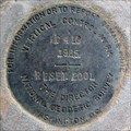
| KYDOH M-4, Jessamine County, KY in U.S. Benchmarks Southeast of Harrodsburg Rd. posted by: wuja location: Kentucky date approved: 05/13/2007 last visited: never |
 view gallery view galleryN3.7 km | KYDOH M-5, Jessamine County, KY in U.S. Benchmarks East of Harrodsburg Rd. posted by: wuja location: Kentucky date approved: 05/13/2007 last visited: never |
 view gallery view gallery SW3.9 km SW3.9 km
|  Asbury College/Bethel Academy - Wilmore, KY Asbury College/Bethel Academy - Wilmore, KY
in Kentucky Historical Markers Asbury College/Bethel Academy, Marker #1830 is located at the entrance to the campus in Wilmore, Kentucky. posted by: silverquill location: Kentucky date approved: 10/04/2007 last visited: 12/18/2012 |
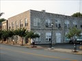
 view gallery view gallerySW3.9 km |  Wilmore, KY Wilmore, KY
in City and Town Halls This old stone building, located in the Main Street Historic District, serves as the city hall and police station for the town of Wilmore, Kentucky, best known as home of Asbury College and Asbury Seminary. posted by: silverquill location: Kentucky date approved: 02/03/2009 last visited: never |
 view gallery view gallerySW3.9 km |  Police Department - Wilmore, KY Police Department - Wilmore, KY
in Police Stations This unique stone building houses the town offices and the police department for the college town of Wilmore, Kentucky, home of Asbury College and Asbury Theological Seminary. posted by: silverquill location: Kentucky date approved: 01/18/2008 last visited: 01/15/2017 |
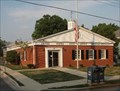 view gallery view gallerySW3.9 km |  Wilmore, KY 40309 Wilmore, KY 40309
in U.S. Post Offices Wilmore, Kentucky, located south of Lexington, is home to Asbury College and Asbury Theological Seminary. The post office is located in the historic downtown district. posted by: silverquill location: Kentucky date approved: 10/03/2007 last visited: 12/02/2008 |
 view gallery view galleryN4.2 km | KYDOH M-6, Jessamine County, KY in U.S. Benchmarks East of Harrodsburg Rd. posted by: wuja location: Kentucky date approved: 05/14/2007 last visited: 08/10/2011 |
 view gallery view gallery W4.2 km W4.2 km
|  Water Tower - Wilmore, KY Water Tower - Wilmore, KY
in Water Towers This water tower is on a hill behind the phyisical education building on the campus of Asbury College overlooking the town of Wilmore, Kentucky. A cross is mounted on the top of the tower. posted by: silverquill location: Kentucky date approved: 01/18/2008 last visited: 08/22/2023 |
 view gallery view gallery E4.2 km E4.2 km
|  Courthouse Clock - Jessamine County, KY Courthouse Clock - Jessamine County, KY
in Town Clocks This clock sits atop the Jessamine County Courthouse in Nicholasville, Kentucky. posted by: BluegrassCache location: Kentucky date approved: 01/07/2008 last visited: 05/14/2011 |
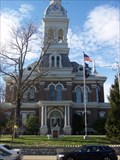 view gallery view galleryE4.2 km |  Jessamine County Courthouse Jessamine County Courthouse
in Courthouses Nicholasville is the county seat for Jessamine County and the home of the courthouse. On the courthouse lawn is a memorial to the Confederate Soldiers who died which was listed on the National Register of Historic Places in 1997. posted by: BluegrassCache location: Kentucky date approved: 01/07/2008 last visited: 07/16/2012 |
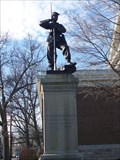 view gallery view galleryE4.3 km |  Confederate Memorial in Nicholasville Confederate Memorial in Nicholasville
in U.S. National Register of Historic Places This Confederate Monument is located on the courthouse lawn in Jessamine County, Kentucky. posted by: BluegrassCache location: Kentucky date approved: 01/07/2008 last visited: 10/25/2008 |
 view gallery view galleryE4.3 km |  Confederate Memorial in Nicholasville Confederate Memorial in Nicholasville
in American Civil War Monuments and Memorials The monument, located on the Jessamine County Courthouse Lawn, was listed on the National Register of Historic Places in 1997. posted by: BluegrassCache location: Kentucky date approved: 01/07/2008 last visited: never |
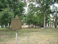
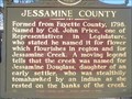 view gallery view galleryE4.3 km | Jessamine County in Kentucky Historical Markers Formed from Fayette County, 1798. Named by Col. John Price, one of Representatives in Legislature, who stated he named it for flower which flourishes in region and for Jessamine Creek. posted by: BluegrassCache location: Kentucky date approved: 01/13/2008 last visited: never |
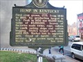 view gallery view galleryE4.3 km | Jessamine County Hemp in Kentucky Historical Markers One of chief producing counties, it was third in value of product and also in the number of cordage factories, with 14 in 1840. posted by: BluegrassCache location: Kentucky date approved: 01/13/2008 last visited: 06/08/2017 |
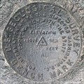 view gallery view galleryN5.1 km | USGS 47 ADP 1950 RESET, Jessamine County, KY in U.S. Benchmarks Northeast of intersection of Harrodsburg Rd. and Keene Rd. It (or its predecessor) is shown as a vertical control mark BM 958 on the Nicholasville, KY topo quad. posted by: wuja location: Kentucky date approved: 05/14/2007 last visited: never |
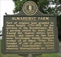 view gallery view galleryN5.3 km | Almahurst Farm - Nicholasville, KY in Kentucky Historical Markers Part of original land granted to James Knight, 1750-1831, for his services in the Revolutionary War. A portion owned by heirs, 1962. Among the famous horses bred, foaled, and raised on this farm were: Greyhound, world's champion trotter of all times; posted by: silverquill location: Kentucky date approved: 10/04/2007 last visited: never |
 view gallery view gallery NE5.3 km NE5.3 km
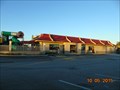
|  McDonalds Restaurant - Imperial Way, Nicholasville, KY McDonalds Restaurant - Imperial Way, Nicholasville, KY
in McDonald's Restaurants McDonald's Restaurant - 100 Imperial Way, Nicholasville, KY 40356 posted by:  walkingwildly walkingwildly location: Kentucky date approved: 11/04/2015 last visited: 11/11/2015 |
 view gallery view galleryNE5.3 km |  McDonalds Restaurant - WiFi Hotspot - Nicholasville, KY McDonalds Restaurant - WiFi Hotspot - Nicholasville, KY
in Wi-Fi Hotspots McDonald's Restaurant - WiFi Hotspot - Nicholasville, Kentucky 40356 posted by: walkingwildly location: Kentucky date approved: 10/23/2015 last visited: 10/30/2015 |
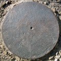
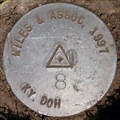 view gallery view galleryN6.1 km | KYDOH M-8, Jessamine County, KY in U.S. Benchmarks West of Harrodsburg Rd. posted by: wuja location: Kentucky date approved: 05/14/2007 last visited: never |
 view gallery view gallerySW6.1 km | C 410 RESET, AJ8430, Jessamine County, KY in U.S. Benchmarks Vertical control disk in bridge abutment. posted by: wuja location: Kentucky date approved: 03/06/2008 last visited: never |
 view gallery view galleryW6.3 km | N N 9 at Pump Station Road, Wilmore, KY in U.S. Benchmarks About halfway down the Pump Station Road and at the west edge of an intermediate station of water pipeline from Kentucky River to Wilmore. The mark is located in the Asbury Trails preserve. posted by: wuja location: Kentucky date approved: 04/30/2007 last visited: never |
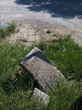
 view gallery view galleryW7.2 km |  Jessamine-Woodford Counties Boundary Monument on Pekin/Troy Pike, KY Jessamine-Woodford Counties Boundary Monument on Pekin/Troy Pike, KY
in U.S. Historic Survey Stones and Monuments Concrete post with letter 'J' on the Jessamine County side and letter 'W' on the Woodford County side. Out of the ground and lying flat. Shown as a boundary monument on the Keene, KY 7.5' topo. posted by: wuja location: Kentucky date approved: 05/14/2007 last visited: never |
 view gallery view galleryNW7.2 km | Jessamine-Woodford Counties Boundary Monument on Troy Rd, KY in U.S. Historic Survey Stones and Monuments Dressed stone with letter 'W' on the Woodford County side. Jessamine County side is damaged and unreadable. Shown as a boundary monument on the Keene, KY 7.5' topo. posted by: wuja location: Kentucky date approved: 05/14/2007 last visited: never |
|