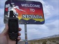
 view gallery view gallery N5.6 km N5.6 km
|   California - Nevada Hwy 6 California - Nevada Hwy 6
in Border Crossings State Boundary on Hwy 6 posted by:  Uncle Alaska Uncle Alaska location: Nevada date approved: 10/17/2005 last visited: 10/03/2015 |
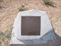 view gallery view gallery SW40.6 km SW40.6 km
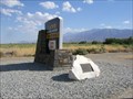
|  Owens Valley Owens Valley
in E Clampus Vitus Historical Markers Marker located at Owens Valley Overlook on California's Highway 395 posted by:  Bernd das Brot Team Bernd das Brot Team location: California date approved: 07/31/2010 last visited: 11/12/2013 |
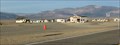
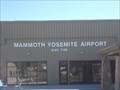 view gallery view gallerySW40.6 km |  Mammoth /Yosemite Airport Mammoth Lake CA Mammoth /Yosemite Airport Mammoth Lake CA
in Airports City property in Mono County, this is a seasonal facility 7 miles east of Mammoth Lakes. It serves the East Sierra region. It is at 6,781 feet. posted by: sbcamper location: California date approved: 12/12/2018 last visited: never |
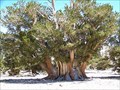 view gallery view gallery SE41 km SE41 km
|  The largest of the oldest - Patriarch Grove The largest of the oldest - Patriarch Grove
in Exceptional Trees Bristlecone Pine trees live longer than 4,000 years. This is not the oldest, but the largest bristlecone pine tree in the world. posted by: Bernd das Brot Team location: California date approved: 08/21/2006 last visited: 06/15/2016 |
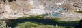 view gallery view gallerySW41.8 km |  Hot Creek, Inyo National Forest Hot Creek, Inyo National Forest
in Hot Springs A hot spring turning a cold river in to a toursit attraction posted by: Bernd das Brot Team location: California date approved: 08/29/2006 last visited: 05/30/2010 |
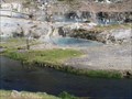 view gallery view gallerySW41.8 km |  Hot Creek Geologic Area – Long Valley Caldera Hot Creek Geologic Area – Long Valley Caldera
in Places of Geologic Significance Hot Creek is one of many hydrothermal springs in the Long Valley Caldera. Infiltrating snowmelt from the Eastern Sierras becomes heated by magma then returns to the surface along faults and fractures. posted by:  TerryDad2 TerryDad2 location: California date approved: 01/01/2010 last visited: 06/16/2016 |
 view gallery view gallery NE44.9 km NE44.9 km
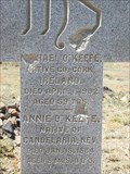
|  Candelaria, Nevada (USA) Cemetery Candelaria, Nevada (USA) Cemetery
in Abandoned Cemeteries Candelaria, Nevada Cemetery posted by: Nevada Desert Rat location: Nevada date approved: 11/02/2006 last visited: 11/03/2006 |
 view gallery view gallery W45.5 km W45.5 km
|  Lookout Loop Mammoth Lookout Loop Mammoth
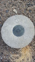
in U.S. Benchmarks This Survey marker is on the lookout loop, at the intersection of 3S41 and 3S12. posted by: Team Ulogoit location: California date approved: 08/25/2008 last visited: never |
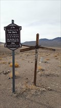 view gallery view galleryNE45.7 km |  Belleville Cemetery - Mineral County, NV Belleville Cemetery - Mineral County, NV
in Worldwide Cemeteries The once-abandoned cemetery to the former mining town of Belleville. posted by: NW_history_buff location: Nevada date approved: 04/03/2018 last visited: never |
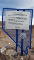 view gallery view galleryNE46.2 km |  Belleville Belleville
in Nevada Historical Markers An official Nevada historical marker located just off Hwy 360. posted by: NW_history_buff location: Nevada date approved: 04/17/2018 last visited: never |
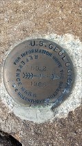 view gallery view galleryNE47.3 km | AH8153 - USGS 'BELL' Reference Mark 2 - Mineral County, NV in U.S. Benchmarks An NGS reference marks as part of the BELL series of marks located just off Hwy 360. posted by: NW_history_buff location: Nevada date approved: 04/09/2018 last visited: never |
 view gallery view galleryNE47.3 km | AH8153 - USGS 'BELL' Triangulation Station - Mineral County, NV in U.S. Benchmarks An NGS triangulation station as part of the 'BELL' series of marks located just of Hwy 360. posted by: NW_history_buff location: Nevada date approved: 04/09/2018 last visited: never |
 view gallery view galleryNE47.3 km | AH8153 - USGS 'BELL' Reference Mark 1 - Mineral County, NV in U.S. Benchmarks An NGS reference marks as part of the BELL series of marks located just off Hwy 360. posted by: NW_history_buff location: Nevada date approved: 04/09/2018 last visited: never |
 view gallery view gallery S47.5 km S47.5 km
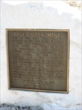
| Pine Creek Mine - Bishop, CA in E Clampus Vitus Historical Markers This has a nice view of the mountains. posted by: bluesnote location: California date approved: 04/19/2010 last visited: 04/19/2010 |
 view gallery view galleryNE49.6 km | JR0252 - USC&GS 'L 359' BM - Mineral County, NV in U.S. Benchmarks An NGS benchmark located south of Hwy 360. posted by: NW_history_buff location: Nevada date approved: 04/09/2018 last visited: never |
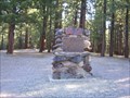
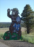 view gallery view galleryW49.6 km |  Smokey Bear Flat - CA Smokey Bear Flat - CA
in Smokey Bear Sign Sightings Smokey and his friends are hanging out in Smokey Bear Flat! posted by: Free2bme29 location: California date approved: 07/15/2009 last visited: 10/03/2015 |
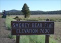 view gallery view galleryW49.7 km |  Smokey Bear Flat, CA 7600 Feet Smokey Bear Flat, CA 7600 Feet
in Elevation Signs This meadow known as Smokey Bear Flat can be found on Hwy 395 north of Mammoth. posted by: Free2bme29 location: California date approved: 07/15/2009 last visited: 09/23/2022 |
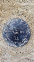
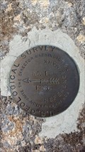
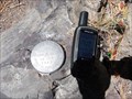 view gallery view galleryW50.2 km | US Dept of Interior Geological Survey 34 JCM 1984 in U.S. Benchmarks This is a Geological Survey Marker in a Rock on Mammoth Scenic Loop posted by: jimnade location: California date approved: 05/30/2015 last visited: 09/23/2022 |
 view gallery view galleryW50.2 km | Lost Cement Mine - Crestwood, CA in E Clampus Vitus Historical Markers This ECV marker can be found in the Crestwood Rest Stop. posted by: Free2bme29 location: California date approved: 07/15/2009 last visited: 09/14/2021 |
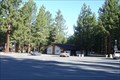 view gallery view galleryW50.2 km |  Crestwood Rest Area - 395 SB - CA Crestwood Rest Area - 395 SB - CA
in Highway Rest Areas This rest area is used by both north and southbound traffic but is located on the SB side of 395. This is a long stretch of road with no services so this is a great place to stop and move around. posted by: Free2bme29 location: California date approved: 07/15/2009 last visited: 09/16/2021 |
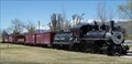 view gallery view galleryS50.7 km |  Laws Narrow Gauge Railroad Historic District Laws Narrow Gauge Railroad Historic District
in U.S. National Register of Historic Places Located on the grounds of the historic Laws Station Museum, this small community run museum is a short drive from Bishop, CA just off of Hwy 395. The museum itself is immaculately cared for and offers a wealth of information about the history of the area. posted by: Touchstone location: California date approved: 09/10/2006 last visited: 05/30/2000 |
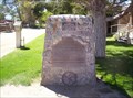 view gallery view galleryS50.7 km |  Laws Station #953 Laws Station #953
in California Historical Markers Located a short drive from Bishop, CA and Hwy 395, this community run Museum is also home to Historical Marker Number 953. The marker is located within the grounds of the Museum, and a small donation is requested to tour the grounds. posted by: Touchstone location: California date approved: 09/10/2006 last visited: 04/14/2012 |
 view gallery view galleryS50.7 km | Owensville - Bishop, CA in E Clampus Vitus Historical Markers This marker is just outside Bishop near Laws Museum. posted by: Free2bme29 location: California date approved: 07/06/2009 last visited: 09/14/2021 |
 view gallery view galleryNE50.7 km |  Coaldale, Nevada Coaldale, Nevada
in Ghost Towns This is really no more than a wide spot in the road now, just a ghost town. posted by: Queens Blessing location: Nevada date approved: 12/26/2012 last visited: 03/12/2010 |
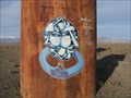 view gallery view galleryNE50.9 km |  Headed Which Way?, Coaldale, NV Headed Which Way?, Coaldale, NV
in Graffiti My husband and I were geocaching and sight-seeing and stumbled across this graffiti. posted by: Queens Blessing location: Nevada date approved: 12/09/2012 last visited: 03/12/2010 |
|