 view gallery view gallery NW19.8 km NW19.8 km
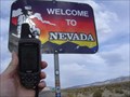
|   California - Nevada Hwy 6 California - Nevada Hwy 6
in Border Crossings State Boundary on Hwy 6 posted by:  Uncle Alaska Uncle Alaska location: Nevada date approved: 10/17/2005 last visited: 10/03/2015 |
 view gallery view gallery S32.5 km S32.5 km
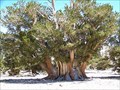
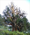
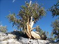
|  The largest of the oldest - Patriarch Grove The largest of the oldest - Patriarch Grove
in Exceptional Trees Bristlecone Pine trees live longer than 4,000 years. This is not the oldest, but the largest bristlecone pine tree in the world. posted by:  Bernd das Brot Team Bernd das Brot Team location: California date approved: 08/21/2006 last visited: 06/15/2016 |
 view gallery view gallery NE38.6 km NE38.6 km
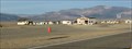
|  Coaldale, Nevada Coaldale, Nevada
in Ghost Towns This is really no more than a wide spot in the road now, just a ghost town. posted by:  Queens Blessing Queens Blessing location: Nevada date approved: 12/26/2012 last visited: 03/12/2010 |
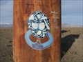 view gallery view galleryNE38.6 km |  Headed Which Way?, Coaldale, NV Headed Which Way?, Coaldale, NV
in Graffiti My husband and I were geocaching and sight-seeing and stumbled across this graffiti. posted by: Queens Blessing location: Nevada date approved: 12/09/2012 last visited: 03/12/2010 |
 view gallery view gallery N40.1 km N40.1 km
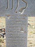
|  Candelaria, Nevada (USA) Cemetery Candelaria, Nevada (USA) Cemetery
in Abandoned Cemeteries Candelaria, Nevada Cemetery posted by: Nevada Desert Rat location: Nevada date approved: 11/02/2006 last visited: 11/03/2006 |
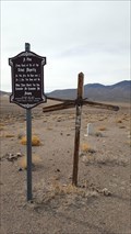 view gallery view galleryN44.4 km |  Belleville Cemetery - Mineral County, NV Belleville Cemetery - Mineral County, NV
in Worldwide Cemeteries The once-abandoned cemetery to the former mining town of Belleville. posted by: NW_history_buff location: Nevada date approved: 04/03/2018 last visited: never |
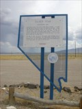
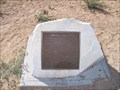
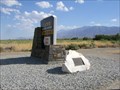
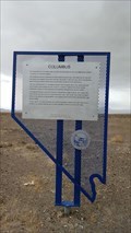 view gallery view galleryNE44.6 km |  Columbus Columbus
in Nevada Historical Markers The remains of former Columbus are located about 4.75 miles SW of this official Nevada historical marker. posted by: NW_history_buff location: Nevada date approved: 04/17/2018 last visited: 08/03/2023 |
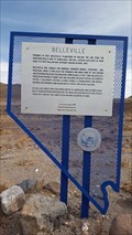 view gallery view galleryN45.2 km | Belleville in Nevada Historical Markers An official Nevada historical marker located just off Hwy 360. posted by: NW_history_buff location: Nevada date approved: 04/17/2018 last visited: never |
 view gallery view galleryNE45.7 km |  OAL - Coaldale VORTAC - Coaldale, Nevada OAL - Coaldale VORTAC - Coaldale, Nevada
in Ground Based Air Navigation Support Structures VORTAC facility located in Coaldale, NV and owned by Federal Aviation Admin. posted by: AnthemRose location: Nevada date approved: 09/09/2018 last visited: never |
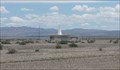
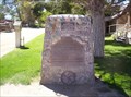
 view gallery view galleryNE46 km | #155 - Silver Peak in Nevada Historical Markers Historical marker is located on the south side of US Highways 95/6 at their junction with Nevada State Route 265. Route 265 is the only paved access to 'The Peak', approximately 22 miles to the south-southeast. posted by: Nevada Desert Rat location: Nevada date approved: 06/19/2007 last visited: 11/30/2023 |
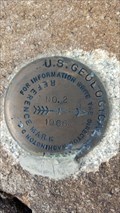
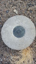
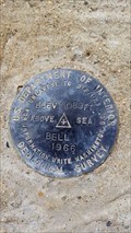 view gallery view galleryN46.3 km |  AH8153 - USGS 'BELL' Triangulation Station - Mineral County, NV AH8153 - USGS 'BELL' Triangulation Station - Mineral County, NV
in U.S. Benchmarks An NGS triangulation station as part of the 'BELL' series of marks located just of Hwy 360. posted by: NW_history_buff location: Nevada date approved: 04/09/2018 last visited: never |
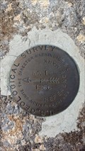 view gallery view galleryN46.3 km | AH8153 - USGS 'BELL' Reference Mark 1 - Mineral County, NV in U.S. Benchmarks An NGS reference marks as part of the BELL series of marks located just off Hwy 360. posted by: NW_history_buff location: Nevada date approved: 04/09/2018 last visited: never |
 view gallery view galleryN46.3 km | AH8153 - USGS 'BELL' Reference Mark 2 - Mineral County, NV in U.S. Benchmarks An NGS reference marks as part of the BELL series of marks located just off Hwy 360. posted by: NW_history_buff location: Nevada date approved: 04/09/2018 last visited: never |
 view gallery view gallery SW46.5 km SW46.5 km
|  Owens Valley Owens Valley
in E Clampus Vitus Historical Markers Marker located at Owens Valley Overlook on California's Highway 395 posted by: Bernd das Brot Team location: California date approved: 07/31/2010 last visited: 11/12/2013 |
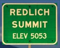 view gallery view galleryNE46.8 km |  Redlich Summit ~ Elevation 5053 Feet Redlich Summit ~ Elevation 5053 Feet
in Elevation Signs This Elevation Sign is located at the top of Redlich Summit on US Highway 95. posted by: brwhiz location: Nevada date approved: 09/21/2012 last visited: 03/28/2013 |
 view gallery view galleryS47.5 km |  Laws Station #953 Laws Station #953
in California Historical Markers Located a short drive from Bishop, CA and Hwy 395, this community run Museum is also home to Historical Marker Number 953. The marker is located within the grounds of the Museum, and a small donation is requested to tour the grounds. posted by: Touchstone location: California date approved: 09/10/2006 last visited: 04/14/2012 |
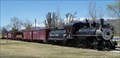 view gallery view galleryS47.5 km |  Laws Narrow Gauge Railroad Historic District Laws Narrow Gauge Railroad Historic District
in U.S. National Register of Historic Places Located on the grounds of the historic Laws Station Museum, this small community run museum is a short drive from Bishop, CA just off of Hwy 395. The museum itself is immaculately cared for and offers a wealth of information about the history of the area. posted by: Touchstone location: California date approved: 09/10/2006 last visited: 05/30/2000 |
 view gallery view galleryN47.5 km | JR0252 - USC&GS 'L 359' BM - Mineral County, NV in U.S. Benchmarks An NGS benchmark located south of Hwy 360. posted by: NW_history_buff location: Nevada date approved: 04/09/2018 last visited: never |
 view gallery view galleryS47.8 km | Owensville - Bishop, CA in E Clampus Vitus Historical Markers This marker is just outside Bishop near Laws Museum. posted by: Free2bme29 location: California date approved: 07/06/2009 last visited: 09/14/2021 |
 view gallery view galleryS48.4 km |  Methuselah Trail - Inyo National Forest, CA Methuselah Trail - Inyo National Forest, CA
in Scenic Hikes The Great Basin Bristlecone Pine, among the oldest living organisms on earth, is the star of this remote 4½-mile hike with spectacular desert views. posted by: hykesj location: California date approved: 05/02/2024 last visited: never |
 view gallery view galleryS49.2 km | The World's Oldest Trees - Methuselah Grove in Exceptional Trees This grove is home to the world's oldest trees, all more than 4,000 years old. Earth's oldest living inhabitant "Methuselah" has reached the age of 4,768 years posted by: Bernd das Brot Team location: California date approved: 08/20/2006 last visited: 10/03/2015 |
 view gallery view galleryS49.2 km |  Methuselah Grove, California Methuselah Grove, California
in Names From the Bible The world's oldest tree, named after the oldest man in the Old Testament. posted by: Bernd das Brot Team location: California date approved: 11/08/2007 last visited: 10/03/2015 |
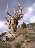 view gallery view galleryS49.2 km |  Methuselah - The World's Oldest Tree Methuselah - The World's Oldest Tree
in Guinness World Records Earth's oldest living inhabitant "Methuselah" has reached the age of 4,768 years. posted by: Bernd das Brot Team location: California date approved: 09/14/2006 last visited: 10/03/2015 |
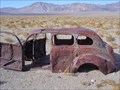 view gallery view galleryN50.9 km |  Car Near old "Tonopah Jct" Car Near old "Tonopah Jct"
in Abandoned Dead Vehicles Found while geocaching...not much around but the "T" jct of two highways. posted by: Uncle Alaska location: Nevada date approved: 11/23/2005 last visited: 10/16/2013 |
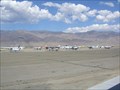 view gallery view galleryS51 km |  Eastern Sierra Regional Airport - Bishop, CA Eastern Sierra Regional Airport - Bishop, CA
in Airports This airport is also known as the Bishop Airport. posted by: Free2bme29 location: California date approved: 07/17/2009 last visited: 10/03/2015 |
|