 view gallery view gallery SW8.4 km SW8.4 km
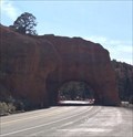
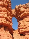
|   Red Canyon Arch (EAST) - Panguitch, UT Red Canyon Arch (EAST) - Panguitch, UT
in Natural Arches One of two arches along highway 12. posted by:  bluesnote bluesnote location: Utah date approved: 05/26/2018 last visited: 11/16/2018 |
 view gallery view gallerySW8.4 km |  Red Canyon Arch (EAST) - Scenic Byway 12 - Panguitch, UT Red Canyon Arch (EAST) - Scenic Byway 12 - Panguitch, UT
in National Scenic Byways One of two arches along highway 12. posted by: bluesnote location: Utah date approved: 05/24/2018 last visited: 10/15/2023 |
 view gallery view gallerySW8.4 km | Red Canyon Arch (WEST) - Scenic Byway 12 - Panguitch, UT in National Scenic Byways One of two arches along highway 12. posted by: bluesnote location: Utah date approved: 05/24/2018 last visited: 10/15/2023 |
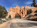 view gallery view gallerySW8.4 km | Red Canyon Arch (WEST) - Panguitch, UT in Natural Arches One of two arches along highway 12. posted by: bluesnote location: Utah date approved: 05/26/2018 last visited: 11/13/2019 |
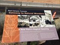
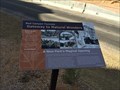 view gallery view gallerySW8.5 km |  Gateway to Natural Wonders (WEST) - Panguitch, UT Gateway to Natural Wonders (WEST) - Panguitch, UT
in Utah Historical Markers One of a few markers located along Highway 12. posted by: bluesnote location: Utah date approved: 06/09/2018 last visited: 11/13/2019 |
 view gallery view gallerySW8.5 km | Gateway to Natural Wonders (WEST) - Scenic Byway 12 - Panguitch, UT in National Scenic Byways One of a few markers located along Highway 12. posted by: bluesnote location: Utah date approved: 05/24/2018 last visited: 11/13/2019 |
 view gallery view gallerySW8.5 km | Gateway to Natural Wonders (EAST) - Scenic Byway 12 - Panguitch, UT in National Scenic Byways One of a few markers located along Highway 12. posted by: bluesnote location: Utah date approved: 05/24/2018 last visited: 05/24/2018 |
 view gallery view gallerySW8.5 km | Gateway to Natural Wonders (EAST) - Panguitch, UT in Utah Historical Markers One of a few markers located along Highway 12. posted by: bluesnote location: Utah date approved: 06/09/2018 last visited: 06/09/2018 |
 view gallery view gallerySW8.9 km | Red Arch outside of Bryce National Park in Natural Arches Look at this beautiful red arch. posted by:  Team Jackal Team Jackal location: Utah date approved: 04/20/2007 last visited: 11/18/2018 |
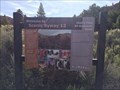
 view gallery view gallerySW9 km |  NOT a National Park NOT a National Park
in National Parks of the World The US Forest Service's Dixie National Forest visitor center and Red Canyon recreation area is along a gorgeous stretch US 12 between Panguitch and Bryce Canyon UT posted by: Benchmark Blasterz location: Utah date approved: 09/26/2014 last visited: 08/03/2020 |
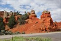
 view gallery view gallerySW9.7 km | Red Canyon - Scenic Byway 12 - Dixie, UT in National Scenic Byways A large geological formation along Highway 12. posted by: bluesnote location: Utah date approved: 05/24/2018 last visited: 09/07/2019 |
 view gallery view gallerySW9.7 km | Scenic Byway 12, Panguitch Utah in National Scenic Byways This route holds 3 Scenic Byways designations. posted by: Queens Blessing location: Utah date approved: 11/23/2012 last visited: 11/15/2018 |
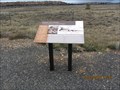
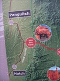 view gallery view gallerySW9.7 km |  You are at Sevier River (Red Canyon), Utah You are at Sevier River (Red Canyon), Utah
in 'You Are Here' Maps This is a beautiful location, in the Red Canyon, Utah. posted by: Queens Blessing location: Utah date approved: 11/22/2012 last visited: 05/05/2018 |
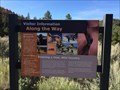 view gallery view gallerySW9.7 km | Along the Way - Scenic Byway 12 - Dixie, UT in National Scenic Byways One of a few historical signs at the entrance to Red Canyon. posted by: bluesnote location: Utah date approved: 08/13/2018 last visited: 08/13/2018 |
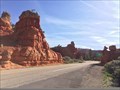
 view gallery view gallerySW9.7 km |  Red Canyon - Dixie, UT Red Canyon - Dixie, UT
in Official Local Tourism Attractions A roadside overlook at the entrance to Dixie National Forrest in Dixie. posted by: bluesnote location: Utah date approved: 05/24/2018 last visited: 11/13/2019 |
 view gallery view gallerySW9.7 km |  FIRST -- All-American Road in Utah - Dixie, UT FIRST -- All-American Road in Utah - Dixie, UT
in First of its Kind One of a few historical markers at the entrance to Red Canyon. posted by: bluesnote location: Utah date approved: 08/13/2018 last visited: 08/13/2018 |
 view gallery view gallerySW9.7 km |  OLDEST -- All-American Road in Utah - Dixie, UT OLDEST -- All-American Road in Utah - Dixie, UT
in Superlatives One of a few historical markers at the entrance to Red Canyon. posted by: bluesnote location: Utah date approved: 08/13/2018 last visited: 11/13/2019 |
 view gallery view gallerySW9.7 km | Scenic Byway 12 - Dixie, UT in Utah Historical Markers One of a few historical markers at the entrance to Red Canyon. posted by: bluesnote location: Utah date approved: 09/08/2018 last visited: 09/08/2018 |
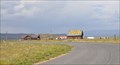
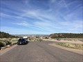 view gallery view gallerySW9.7 km |  Red Canyon Overlook - Dixie, UT Red Canyon Overlook - Dixie, UT
in Scenic Roadside Look-Outs A roadside overlook at the entrance to Dixie National Forrest in Dixie. posted by: bluesnote location: Utah date approved: 05/26/2018 last visited: 11/13/2019 |
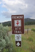 view gallery view gallery S9.8 km S9.8 km
|  Freemont ATV Trail -- Dixie National Forest, UT Freemont ATV Trail -- Dixie National Forest, UT
in Offroad Trails A well-used and well-kept ATV trail in the Dixie National Forest. The additional access point listed below is for the Freemont ATV Trailhead at Tropic Reservior. posted by: Benchmark Blasterz location: Utah date approved: 08/28/2014 last visited: 08/04/2014 |
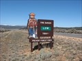 view gallery view gallerySW10.1 km |  Smokey Bear - Dixie National Forest, UT Smokey Bear - Dixie National Forest, UT
in Smokey Bear Sign Sightings A Smokey Bear located on the western side of Dixie National Forest. posted by: Rayman location: Utah date approved: 03/15/2009 last visited: 10/19/2023 |
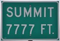 view gallery view galleryS10.6 km |  Bryce Summit ~ Elevation 7777 feet Bryce Summit ~ Elevation 7777 feet
in Elevation Signs This Elevation Sign is a few miles west of the junction of Utah Highway 12 and Utah Highway 63, the road that leads south into Bryce Canyon National Park. posted by: brwhiz location: Utah date approved: 06/15/2011 last visited: 07/06/2017 |
 view gallery view gallery SE14.6 km SE14.6 km
|  Crash of United Flight 608, near Bryce, Utah Crash of United Flight 608, near Bryce, Utah
in Signs of History This sign provides information about a plane crash near this location. posted by: Queens Blessing location: Utah date approved: 12/06/2012 last visited: 10/24/2019 |
 view gallery view gallerySE14.8 km |  Bryce Canyon Airport ~ Bryce Canyon City, Utah Bryce Canyon Airport ~ Bryce Canyon City, Utah
in Airports This Airport is located at 450 N Airport Road in north of Bryce Canyon City, Utah. posted by: brwhiz location: Utah date approved: 03/25/2013 last visited: 08/04/2014 |
 view gallery view gallery W14.8 km W14.8 km
| Panguitch, Utah - Elevation: 6,660 in Elevation Signs The elevation in Panguitch, Utah is 6,660. posted by: JacobBarlow location: Utah date approved: 09/14/2007 last visited: 09/06/2019 |
|