 view gallery view gallery N0.2 km N0.2 km
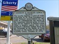
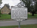
|   Andrew & Charles Lewis March Andrew & Charles Lewis March
in West Virginia Historical Markers A quick description of the trail by Andrew & Charles Lewis plus the battle they fought at Point Pleasant. posted by:  dukemartin dukemartin location: West Virginia date approved: 05/16/2018 last visited: 05/16/2018 |
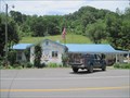 view gallery view galleryN0.3 km |  Green Sulphur Springs WV Post Office - 25966 Green Sulphur Springs WV Post Office - 25966
in U.S. Post Offices The GPS coords for this post office are correct and is on SR 20, a short distance off Exit 143 to the north of I-64. The USPS's on-line Location link shows this P.O. is past Exit 139 near the New River, more than 4 miles away from where it really is. posted by: VQ9JC location: West Virginia date approved: 08/25/2013 last visited: 05/09/2018 |
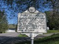 view gallery view gallery NW6 km NW6 km
| Fayette County / Summers County in West Virginia Historical Markers A two sided sign telling where the counties were formed from. posted by: dukemartin location: West Virginia date approved: 05/16/2018 last visited: 05/16/2018 |
 view gallery view galleryNW6.1 km | Meadow Bridge, WV Post Office - 25976 in U.S. Post Offices This post office is located at 9245 Sewell Creek Rd in Meadow Bridge, WV which is in Fayette County posted by: VQ9JC location: West Virginia date approved: 08/24/2013 last visited: 05/09/2018 |
 view gallery view gallery W7.7 km W7.7 km
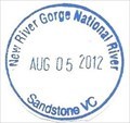
|  New River Gorge National River-Sandstone New River Gorge National River-Sandstone
in NPS Passport Cancellation Stations The New River is like a ribbon tying together all the people, places, and events sharing its course through time. posted by:  Don.Morfe Don.Morfe location: West Virginia date approved: 12/27/2019 last visited: 04/22/2024 |
 view gallery view galleryW7.7 km | ") New River Gorge National River-Sandstone New River Gorge National River-Sandstone
in National Parks (U.S.) The New River is like a ribbon tying together all the people, places, and events sharing its course through time. posted by: Don.Morfe location: West Virginia date approved: 12/27/2019 last visited: 04/22/2024 |
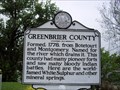
 view gallery view gallery SE15.8 km SE15.8 km
| Greenbrier County / Summers County in West Virginia Historical Markers A two sided sign telling us where the counties were formed from and what they were named after. posted by: dukemartin location: West Virginia date approved: 10/05/2018 last visited: never |
 view gallery view gallery SW16.3 km SW16.3 km
|  Chesapeake & Ohio RR station - Hinton, West Virginia Chesapeake & Ohio RR station - Hinton, West Virginia
in Train Stations/Depots The Hinton Station is located at 100 2nd Ave at Maple Ave. It was built in 1913 for the C&O Railroad. It currently serves Amtrak's Cardinal. posted by: buffalohiker location: West Virginia date approved: 11/06/2019 last visited: 04/22/2024 |
 view gallery view gallerySW16.4 km | Hinton WV 25951 Post Office in U.S. Post Offices Hinton WV, Post Office posted by: dukemartin location: West Virginia date approved: 09/25/2017 last visited: 04/22/2024 |
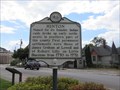 view gallery view gallerySW16.4 km | Hinton in West Virginia Historical Markers A short history of the Hinton WV area. posted by: dukemartin location: West Virginia date approved: 09/18/2017 last visited: 09/18/2017 |
 view gallery view galleryNW16.7 km | Layland Mine Disaster in West Virginia Historical Markers Site of largest mine disaster in Fayette County. posted by: dukemartin location: West Virginia date approved: 05/16/2018 last visited: 05/16/2018 |
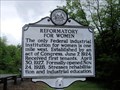 view gallery view gallerySE17.2 km | Reformatory For Women in West Virginia Historical Markers Tells about an institution to reform women. posted by: Paintedwarrior location: West Virginia date approved: 05/11/2012 last visited: 05/13/2012 |
 view gallery view gallerySE17.7 km | Alderson Baptist Academy and Junior College in West Virginia Historical Markers A sign telling us some of the history of the school once located here. posted by: dukemartin location: West Virginia date approved: 10/05/2018 last visited: never |
 view gallery view gallerySE17.7 km | Alderson Depot - Alderson, WV in Train Stations/Depots C&O depot in Alderson, West Virginia. posted by: bitmapped location: West Virginia date approved: 07/31/2008 last visited: 11/04/2007 |
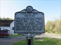
 view gallery view gallerySE17.7 km | Alderson in West Virginia Historical Markers Tells about the first Baptist Church in the Greenbrier Valley. posted by: Paintedwarrior location: West Virginia date approved: 05/11/2012 last visited: 05/13/2012 |
 view gallery view gallerySE17.9 km | Alderson, WV, 24910 in U.S. Post Offices Alderson, West Virginia, 24910, Post Office posted by: dukemartin location: West Virginia date approved: 05/09/2012 last visited: never |
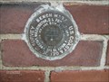 view gallery view gallerySE17.9 km |  Alderson, WV Benchmark Alderson, WV Benchmark
in U.S. Benchmarks Designation: A 202
Marker Type: bench mark disk
Setting: massive structures
Stability: Probably hold position/elevation well. posted by: AK-Jeff location: West Virginia date approved: 07/30/2007 last visited: 11/14/2010 |
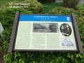
 view gallery view gallerySE17.9 km |  Alderson Memorial Bridge History - Alderson WV Alderson Memorial Bridge History - Alderson WV
in Signs of History The marker is attached to the bridge at 100 N Monroe St, Alderson WV 24910 posted by: Don.Morfe location: West Virginia date approved: 10/05/2023 last visited: 10/05/2023 |
 view gallery view gallerySE17.9 km |  Skirmish at Alderson's Ferry - Alderson WV Skirmish at Alderson's Ferry - Alderson WV
in Battlefields Because of the importance of the ferry, occasionally engagements were fought here as each side sought to control the crossing or deny the ferry’s use to the enemy. posted by: Don.Morfe location: West Virginia date approved: 11/21/2020 last visited: 10/16/2021 |
 view gallery view gallerySE17.9 km |  Aldersons Ferry-Strategic Crossing - Alderson WV Aldersons Ferry-Strategic Crossing - Alderson WV
in Civil War Discovery Trail Sites Here, where you are standing, you can see both sides of the Greenbrier River where Alderson’s Ferry crossed. posted by: Don.Morfe location: West Virginia date approved: 03/10/2020 last visited: 10/08/2021 |
 view gallery view gallerySE17.9 km | Alderson's Ferry-Strategic Crossing - Alderson WV in U.S. Civil War Sites During the Civil War, the ferry played a significant role as both Union and Confederate forces used it to carry men and supplies across the river here. On June 22, 1862, 1,600 Federal troops were ferried over the river here on an expeditiion. posted by: Don.Morfe location: West Virginia date approved: 07/01/2023 last visited: 07/01/2023 |
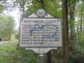
 view gallery view gallerySE17.9 km | Greenbrier County Monroe County in West Virginia Historical Markers A two sided sign telling were the counties were formed from and what they were named after. posted by: Paintedwarrior location: West Virginia date approved: 05/11/2012 last visited: 05/13/2012 |
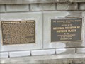
 view gallery view gallerySE17.9 km |  Alderson Bridge - Alderson WV Alderson Bridge - Alderson WV
in U.S. National Register of Historic Places The Alderson Bridge, also known as Alderson Memorial Bridge, is a historic concrete arch bridge in Alderson, West Virginia. It crosses the Greenbrier River, which separates Greenbrier and Monroe counties. posted by: Don.Morfe location: West Virginia date approved: 10/05/2023 last visited: 10/05/2023 |
 view gallery view gallerySE17.9 km |  Alderson Bridge - Alderson WV Alderson Bridge - Alderson WV
in Wikipedia Entries The Alderson Bridge, also known as Alderson Memorial Bridge, is a historic concrete arch bridge in Alderson, West Virginia. It crosses the Greenbrier River, which separates Greenbrier and Monroe counties. posted by: Don.Morfe location: West Virginia date approved: 10/05/2023 last visited: 10/05/2023 |
 view gallery view gallerySE17.9 km |  Alderson Bridge - Alderson WV Alderson Bridge - Alderson WV
in Arch Bridges The Alderson Bridge, also known as Alderson Memorial Bridge, is a historic concrete arch bridge in Alderson, West Virginia. It crosses the Greenbrier River, which separates Greenbrier and Monroe counties. posted by: Don.Morfe location: West Virginia date approved: 10/05/2023 last visited: 10/05/2023 |
|