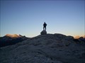
 view gallery view gallery NW11.9 km NW11.9 km
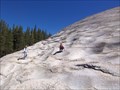
|   Lembert Dome Lembert Dome
in Mountain Summits Located within Yosemite National Park, this high point in Tuolumne Meadows offers a 360 degree view for the price of a moderate hike. posted by:  Touchstone Touchstone location: California date approved: 08/30/2005 last visited: 02/20/2015 |
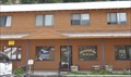
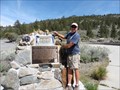
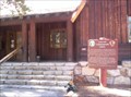 view gallery view galleryNW12.2 km |  Yosemite NP: Tuolumne Meadows Visitors Center Yosemite NP: Tuolumne Meadows Visitors Center
in NPS Passport Cancellation Stations Located in the historic Visitors Center in Tuolumne Meadows. Coordinates were taken at the base of the stairway leading to the front door. posted by: Touchstone location: California date approved: 08/30/2005 last visited: 06/26/2014 |
 view gallery view galleryNW12.2 km |  Yosemite NP: Tuolumne Meadows Visitors Center Yosemite NP: Tuolumne Meadows Visitors Center
in Civilian Conservation Corps The CCC was very active in Yosemite National Park between 1933 to 1942. The Tuolumne Meadows Visitors Center is just one of many projects that the CCC performed to make the Park what it is today. posted by: Touchstone location: California date approved: 09/05/2005 last visited: 06/29/2012 |
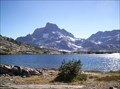 view gallery view gallery SE12.2 km SE12.2 km
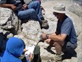
|  1000 Island Lake 1000 Island Lake
in Fishing Holes Maybe not trophy fishing, but this remote lake and the stream that outlets it was memorable to one little boy. posted by: Touchstone location: California date approved: 09/05/2005 last visited: 08/25/2008 |
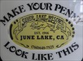 view gallery view gallery E14 km E14 km
|  Silver Lake Resort Penny Smasher Silver Lake Resort Penny Smasher
in Penny Smashers This single-design electric Penny Smasher is in the General Store at the Silver Lake Resort in June Lakes, California. posted by: brwhiz location: California date approved: 08/29/2012 last visited: never |
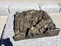
 view gallery view galleryNW14 km |  Pothole Dome Pothole Dome
in Places of Geologic Significance Pothole Dome in Tuolumne Meadows provides an excellent opportunity to view typical glacial erosional and geomorphologic features and some not so typical ones as well. posted by: TerryDad2 location: California date approved: 01/03/2010 last visited: 02/20/2015 |
 view gallery view gallery N17.2 km N17.2 km
|  Bennettville - Yosemite NP, California Bennettville - Yosemite NP, California
in E Clampus Vitus Historical Markers Reason why the Tioga Road was built posted by: jimnade location: California date approved: 06/13/2015 last visited: never |
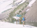 view gallery view galleryN17.4 km |  Yosemite - Ellery Lake Yosemite - Ellery Lake
in Elevation Signs Ellery Lake at the Tioga Pass near the east entrance of Yosemite. posted by:  eveningrose eveningrose location: California date approved: 08/15/2010 last visited: 05/14/2013 |
 view gallery view gallery W17.5 km W17.5 km
|  Avalanche! - Yosemite, CA Avalanche! - Yosemite, CA
in Signs of History One of a few signs of history at Olmsted Point within Yosemite National Park. posted by: bluesnote location: California date approved: 10/20/2016 last visited: 10/20/2016 |
 view gallery view galleryW17.5 km |  Tioga Pass - Yosemite, CA Tioga Pass - Yosemite, CA
in Wikipedia Entries The Tioga Pass is the northern most route into Yosemite Valley. It is also the highest, with parts in excess of 9,000 feet in elevation. posted by: bluesnote location: California date approved: 10/21/2016 last visited: 07/24/1984 |
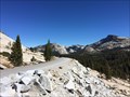
 view gallery view galleryW17.5 km | Olmsted Point - Yosemite, CA in Wikipedia Entries A popular vista point along Tioga Pass Rd within Yosemite National Park. posted by: bluesnote location: California date approved: 10/21/2016 last visited: 10/21/2016 |
 view gallery view galleryW17.5 km |  Olmsted Point - Yosemite, CA Olmsted Point - Yosemite, CA
in Scenic Roadside Look-Outs A popular vista point along Tioga Pass Rd within Yosemite National Park. posted by: bluesnote location: California date approved: 10/21/2016 last visited: 10/21/2016 |
 view gallery view galleryW17.5 km |  Olmsted Point - Yosemite, CA Olmsted Point - Yosemite, CA
in Scenic Overlooks A popular vista point along Tioga Pass Rd within Yosemite National Park. posted by: bluesnote location: California date approved: 10/20/2016 last visited: 10/20/2016 |
 view gallery view galleryW17.5 km |  Olmsted Point - Yosemite, CA Olmsted Point - Yosemite, CA
in Bookcrossing Zones A popular vista point along Tioga Pass Rd within Yosemite National Park. posted by: bluesnote location: California date approved: 01/12/2017 last visited: 01/12/2017 |
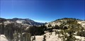
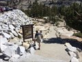 view gallery view galleryW17.5 km |  Olmsted Point Trail - Yosemite, CA Olmsted Point Trail - Yosemite, CA
in Long Distance Hiking Trails A long distance hiking trail on the north side of Yosemite National Park. posted by: bluesnote location: California date approved: 10/20/2016 last visited: 10/20/2016 |
 view gallery view galleryW17.5 km |  Olmsted Point Trail - Yosemite, CA Olmsted Point Trail - Yosemite, CA
in Hiking and walking trailheads A long distance hiking trail on the north side of Yosemite National Park. posted by: bluesnote location: California date approved: 11/02/2016 last visited: 11/02/2016 |
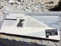
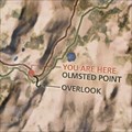 view gallery view galleryW17.5 km |  Olmsted Point Trail Map - Yosemite, CA Olmsted Point Trail Map - Yosemite, CA
in 'You Are Here' Maps A tail map at Olmsted Point in Yosemite National Park. posted by: bluesnote location: California date approved: 10/21/2016 last visited: 10/21/2016 |
 view gallery view galleryW17.5 km |  Olmsted Point Map - Yosemite, CA Olmsted Point Map - Yosemite, CA
in 3D Map Models of Our World and Beyond A 3d map of Yosemite Valley at Olmsted Point. posted by: bluesnote location: California date approved: 10/21/2016 last visited: 10/21/2016 |
 view gallery view galleryN18.2 km | The Tioga Pass Road - Lee Vining CA- Elevation 9945' in Elevation Signs The Tioga Pass Road Constructed 1883 & 1910. Tioga Pass at 9945 feet is the highest automobile pass in California. The road to the pass was constructed in two parts. posted by: Don.Morfe location: California date approved: 08/10/2020 last visited: 10/30/2021 |
 view gallery view galleryE18.7 km |  June Lake, California 93529 June Lake, California 93529
in U.S. Post Offices This Post Office is located at 2747 Boulder Drive in June Lake, California. posted by: brwhiz location: California date approved: 02/05/2013 last visited: never |
 view gallery view gallery NE19.2 km NE19.2 km
| Mono Craters in Places of Geologic Significance This Inyo National Forest sign explaining the significance of volcanic activity in the vicinity of Mono Lake is located in a turnout on the southeast side of California Highway 158 about 1.1 miles southwest of the junction with US Highway 395. posted by: brwhiz location: California date approved: 02/26/2013 last visited: 10/03/2015 |
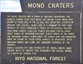 view gallery view galleryNE19.2 km | Mono Craters in Signs of History This Inyo National Forest sign explaining the history of volcanic activity in the vicinity of Mono Lake is located in a turnout on the southeast side of California Highway 158 about 1.1 miles southwest of the junction with US Highway 395. posted by: brwhiz location: California date approved: 02/25/2013 last visited: never |
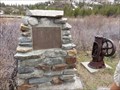
 view gallery view galleryE19.8 km | Legend of June Lake Slot Machine - Mammoth Mountain, California in E Clampus Vitus Historical Markers This is a marker telling the story about slot machines in the June Lake area posted by: jimnade location: California date approved: 06/13/2015 last visited: 06/14/2016 |
 view gallery view galleryN20.3 km |  Mount Conness Mount Conness
in Summit Registers At 12,590 feet, Mount Conness is the tallest peak in the Sierra Nevada North of Tioga Pass. posted by: Touchstone location: California date approved: 08/22/2007 last visited: never |
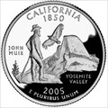 view gallery view galleryW21.9 km |  Half Dome - Yosemite National Park Half Dome - Yosemite National Park
in Numismatic Photographs Issued as part of the United States Mint's 50 State Quarters Program, the California State Quarter first appeared in 2005, the 31st state quarter to be released (to match California being the 31st state admitted to the USA). posted by: DougK location: California date approved: 11/26/2011 last visited: 01/03/2014 |
|