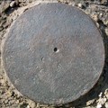
 view gallery view gallery NW2.1 km NW2.1 km
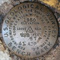
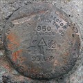
|   USGS 41 ADP 574 1950, Nicholasville, KY USGS 41 ADP 574 1950, Nicholasville, KY
in U.S. Benchmarks Northeast of the old US-27 bridge over Kentucky River near Camp Nelson. Shown as BM 574 (horizontal control with third-order or better elevation) on the Little Hickman, KY topo quadrangle. posted by:  wuja wuja location: Kentucky date approved: 04/29/2007 last visited: never |
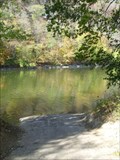
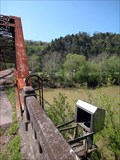 view gallery view galleryNW2.1 km |  Kentucky River at Camp Nelson, Nicholasville, KY Kentucky River at Camp Nelson, Nicholasville, KY
in River Gauges Likely remains of USGS Gauge 03284600. posted by: wuja location: Kentucky date approved: 04/29/2007 last visited: never |
 view gallery view gallery N2.7 km N2.7 km
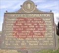
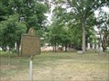
|  Sawyier's Inspiration, Nicholasville, Jessamine County, Kentucky Sawyier's Inspiration, Nicholasville, Jessamine County, Kentucky
in Kentucky Historical Markers Painted scenes of Kentucky River and area. posted by: krsmith2 location: Kentucky date approved: 12/29/2013 last visited: never |
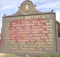 view gallery view galleryN2.7 km | Butler's Birthplace, Nicholasville, Jessamine County, Kentucky in Kentucky Historical Markers Life of Wm. O. Butler. posted by: krsmith2 location: Kentucky date approved: 12/29/2013 last visited: never |
 view gallery view galleryN3.1 km |  General William "Bull" Nelson, Nicholasville, Jessamine County, Kentucky General William "Bull" Nelson, Nicholasville, Jessamine County, Kentucky
in Civil War Discovery Trail Sites The short life of General William "Bull" Nelson. posted by: krsmith2 location: Kentucky date approved: 01/01/2014 last visited: never |
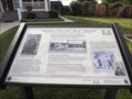
 view gallery view galleryN3.1 km | Camp Nelson National Cemetery, Nicholasville, Jessamine County, Kentucky in Kentucky Historical Markers Forming a nonprofit corporation to reopen and expand Camp Nelson National Cemetery. posted by: krsmith2 location: Kentucky date approved: 12/09/2013 last visited: never |
 view gallery view galleryN3.2 km | Conditions at Refugee Camp, Nicholasville, Jessamine County, Kentucky in Kentucky Historical Markers Life in the refugee camp. posted by: krsmith2 location: Kentucky date approved: 12/07/2013 last visited: never |
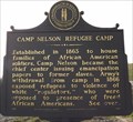 view gallery view galleryN3.2 km | Camp Nelson Refugee Camp, Nicholasville, Jessamine County, Kentucky in Kentucky Historical Markers Established to house families of African American soldiers. posted by: krsmith2 location: Kentucky date approved: 12/07/2013 last visited: 10/17/2014 |
 view gallery view galleryN3.4 km |  William M. Harris-Nicholasville, KY William M. Harris-Nicholasville, KY
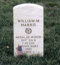
in Medal Of Honor Resting Places Indian Campaigns Medal of Honor Recipient for action at Little Big Honor River, MT on June 25, 1876. He is buried in Camp Nelson National Cemetery, Nicholasville, KY in Section U, Site 3. posted by: Don.Morfe location: Kentucky date approved: 05/14/2018 last visited: 12/13/2021 |
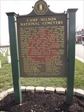
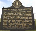 view gallery view galleryN3.4 km | Camp Nelson National Cemetery, Nicholasville, Jessamine County, Kentucky in Kentucky Historical Markers History of Cemetery and burial. posted by: krsmith2 location: Kentucky date approved: 12/29/2013 last visited: 10/17/2014 |
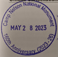 view gallery view galleryN4.3 km |  Camp Nelson National Monument 160th Anniversary (2023-26) Camp Nelson National Monument 160th Anniversary (2023-26)
in NPS Passport Cancellation Stations Cancellation station for Camp Nelson National Monument posted by: Jeefonwaymarking location: Kentucky date approved: 07/04/2023 last visited: never |
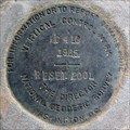
 view gallery view gallery W6 km W6 km
| BM 860, Garrard County, KY in U.S. Benchmarks Only the stem remains. Shown as a vertical control BM 860 on Wilmore, KY topo quad. posted by: wuja location: Kentucky date approved: 09/17/2007 last visited: never |
 view gallery view gallery SW10.8 km SW10.8 km
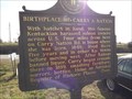
| Birthplace of Carry A. Nation / Lady with the Hatchet, Lancaster, Garrard County, Kentucky in Kentucky Historical Markers Birthplace & Life of Carry A. Nation. posted by: krsmith2 location: Kentucky date approved: 12/30/2013 last visited: never |
 view gallery view gallery NE11.4 km NE11.4 km
| USGS 35 ADP 938 1950, Lexington, KY in U.S. Benchmarks West of Chrisman Mill Rd. posted by: wuja location: Kentucky date approved: 06/03/2007 last visited: never |
 view gallery view galleryNW11.6 km | C 410 RESET, AJ8430, Jessamine County, KY in U.S. Benchmarks Vertical control disk in bridge abutment. posted by: wuja location: Kentucky date approved: 03/06/2008 last visited: never |
 view gallery view galleryNW12.4 km |  Wilmore, KY Wilmore, KY
in City and Town Halls This old stone building, located in the Main Street Historic District, serves as the city hall and police station for the town of Wilmore, Kentucky, best known as home of Asbury College and Asbury Seminary. posted by: silverquill location: Kentucky date approved: 02/03/2009 last visited: never |
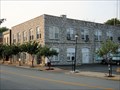 view gallery view galleryNW12.4 km |  Police Department - Wilmore, KY Police Department - Wilmore, KY
in Police Stations This unique stone building houses the town offices and the police department for the college town of Wilmore, Kentucky, home of Asbury College and Asbury Theological Seminary. posted by: silverquill location: Kentucky date approved: 01/18/2008 last visited: 01/15/2017 |
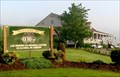 view gallery view gallerySW12.4 km |  Old Bridge Golf Course Old Bridge Golf Course
in Public and Private Golf Courses Located on KY-34 east of Danville, KY posted by:  Web-ling Web-ling location: Kentucky date approved: 05/28/2007 last visited: never |
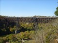 view gallery view galleryNW12.6 km |  High Bridge of Kentucky - near Wilmore, KY High Bridge of Kentucky - near Wilmore, KY
in Railroad Bridges Active rail bridge over the Kentucky River. posted by: kbarhow location: Kentucky date approved: 11/24/2008 last visited: 01/16/2009 |
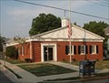 view gallery view galleryNW12.6 km |  Wilmore, KY 40309 Wilmore, KY 40309
in U.S. Post Offices Wilmore, Kentucky, located south of Lexington, is home to Asbury College and Asbury Theological Seminary. The post office is located in the historic downtown district. posted by: silverquill location: Kentucky date approved: 10/03/2007 last visited: 12/02/2008 |
 view gallery view galleryNW12.9 km | Asbury College/Bethel Academy - Wilmore, KY in Kentucky Historical Markers Asbury College/Bethel Academy, Marker #1830 is located at the entrance to the campus in Wilmore, Kentucky. posted by: silverquill location: Kentucky date approved: 10/04/2007 last visited: 12/18/2012 |
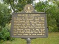 view gallery view galleryNW13.2 km | Shaker Landing, Pleasant Hill, KY in Kentucky Historical Markers Former river crossing and landing near the old Shaker colony known as Pleasant Hill. posted by: kbarhow location: Kentucky date approved: 11/24/2008 last visited: never |
 view gallery view galleryNW13.4 km | N N 9 at Pump Station Road, Wilmore, KY in U.S. Benchmarks About halfway down the Pump Station Road and at the west edge of an intermediate station of water pipeline from Kentucky River to Wilmore. The mark is located in the Asbury Trails preserve. posted by: wuja location: Kentucky date approved: 04/30/2007 last visited: never |
 view gallery view galleryNW13.4 km |  Kentucky River near Lock 7, High Bridge, KY Kentucky River near Lock 7, High Bridge, KY
in Boat Ramps Small private ramp available for use for a fee. Just above Lock 7 on the Kentucky River, near High Bridge. posted by: kbarhow location: Kentucky date approved: 11/23/2008 last visited: never |
 view gallery view galleryNW13.5 km |  Water Tower - Wilmore, KY Water Tower - Wilmore, KY
in Water Towers This water tower is on a hill behind the phyisical education building on the campus of Asbury College overlooking the town of Wilmore, Kentucky. A cross is mounted on the top of the tower. posted by: silverquill location: Kentucky date approved: 01/18/2008 last visited: 08/22/2023 |
|