 view gallery view gallery N7.4 km N7.4 km
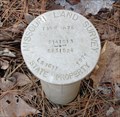
|   LS1611 Missouri Land Survey 1979 LS1611 Missouri Land Survey 1979
in U.S. Benchmarks Missouri Land Survey mark near Hawn State Park. posted by:  dcrep dcrep location: Missouri date approved: 03/23/2008 last visited: never |
 view gallery view gallery NW8.9 km NW8.9 km
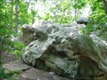
|  Terrapin Rock - Pickle Springs Natural Area - Ste. Genevieve County, Missouri Terrapin Rock - Pickle Springs Natural Area - Ste. Genevieve County, Missouri
in Simulacra Terrapin rock is a rock in the shape of a terrapin type turtle located along the "Trail Through Time" at the Pickle Springs Natural Area.
posted by:  BruceS BruceS location: Missouri date approved: 01/12/2009 last visited: never |
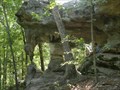 view gallery view galleryNW9 km |  Double Arch, Pickle Springs Natural Area, Farmington, Missouri Double Arch, Pickle Springs Natural Area, Farmington, Missouri
in Natural Arches Nice double arch located in Pickle Springs Natural Area. posted by:  paulspaper paulspaper location: Missouri date approved: 09/15/2008 last visited: 12/03/2010 |
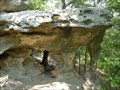 view gallery view galleryNW9 km |  Pickle Springs Natural Area, Farmington, Missouri Pickle Springs Natural Area, Farmington, Missouri
in U.S. National Natural Landmarks Pickle Springs Natural Area features many outstanding natural features. posted by: paulspaper location: Missouri date approved: 09/15/2008 last visited: 09/08/2009 |
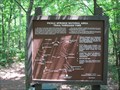
 view gallery view galleryNW9 km |  Pickle Springs Natural Area - Trail Through Time - Ste. Genevieve County, Missouri Pickle Springs Natural Area - Trail Through Time - Ste. Genevieve County, Missouri
in Self Guided Walks and Trails Self guided nature walk through the Pickle Springs Natural Area which is listed as a National Natural Landmark.
posted by: BruceS location: Missouri date approved: 01/03/2009 last visited: 09/08/2009 |
 view gallery view galleryNW9 km |  Pickle Springs Natural Area - Trail Through Time - Ste. Genevieve County, Missouri Pickle Springs Natural Area - Trail Through Time - Ste. Genevieve County, Missouri
in Hiking and walking trailheads Self guided nature trail through the Pickle Springs Natural Area which is listed as a National Natural Landmark. posted by: BruceS location: Missouri date approved: 01/11/2009 last visited: 09/08/2009 |
 view gallery view galleryNW9 km |  Trail Through Time You Are Here Map - Ste. Genevieve County, Missouri Trail Through Time You Are Here Map - Ste. Genevieve County, Missouri
in 'You Are Here' Maps A your are here map at the trail head of Trail Through Time at the Pickle Springs Natural Area which is listed as a National Natural Landmark. posted by: BruceS location: Missouri date approved: 01/04/2009 last visited: 09/08/2009 |
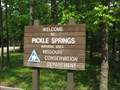 view gallery view galleryNW9 km |  Pickle Springs Natural Area - Ste. Genevieve County, Missouri Pickle Springs Natural Area - Ste. Genevieve County, Missouri
in Public Access Lands Pickle Springs Natural Area which is listed as a National Natural Landmark is managed by the Missouri Department of Conservation.
posted by: BruceS location: Missouri date approved: 01/06/2009 last visited: never |
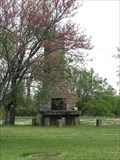 view gallery view galleryN14.8 km |  Officers Club Chimney, Camp Weingarten- Weingarten, Missouri Officers Club Chimney, Camp Weingarten- Weingarten, Missouri
in Lonely Chimneys Camp Weingarten was one of four main P.O.W. camps in Missouri during World War II. The only remains of the camp is this lonely chimney from the officers club, for the officers running the camp. posted by: BruceS location: Missouri date approved: 05/07/2008 last visited: never |
 view gallery view galleryN14.8 km |  Camp Weingarten - Weingarten, Missouri Camp Weingarten - Weingarten, Missouri
in WWII Prisoner of War Camps Camp Weingarten was of of four main P.O.W. camps in Missouri during World War II. The only remains of the camp is this lonely chimney from the officers club, for the officers running the camp.
posted by: BruceS location: Missouri date approved: 05/07/2008 last visited: 12/26/2011 |
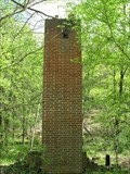 view gallery view galleryN15.3 km | Sawmill Road Chimney - Weingarten, Missouri in Lonely Chimneys Brick chimney along country road called Sawmill Road near Weingarten, Missouri. posted by: BruceS location: Missouri date approved: 05/20/2008 last visited: never |
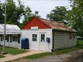 view gallery view gallery SW15.4 km SW15.4 km
|  Knob Lick, MO 63651 Knob Lick, MO 63651
in U.S. Post Offices Small post office connected to general store in this St. Francois County, Missouri town. posted by: Wampa-One location: Missouri date approved: 06/06/2009 last visited: never |
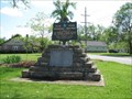
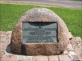 view gallery view gallerySW15.8 km |  FIRST: Lead Mine In The Mississippi Valley - Mine La Motte, Missouri FIRST: Lead Mine In The Mississippi Valley - Mine La Motte, Missouri
in First of its Kind Plaque marking location of first lead mine in the Mississippi Valley. posted by: BruceS location: Missouri date approved: 09/06/2013 last visited: never |
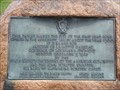 view gallery view gallerySW15.8 km |  First Lead Mine in the Mississippi Valley - Mine La Motte, MO First Lead Mine in the Mississippi Valley - Mine La Motte, MO
in Missouri Historical Markers Tablet on roadside pull-off marking site of lead mine circa 1700 posted by: Wampa-One location: Missouri date approved: 06/12/2009 last visited: never |
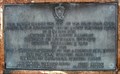 view gallery view gallerySW15.8 km |  First Lead Mine in the Mississippi Valley - Mine La Motte, Missouri First Lead Mine in the Mississippi Valley - Mine La Motte, Missouri
in Mines Southeastern Missouri has been mined for hundreds of years for the lead within the earth. posted by: gparkes location: Missouri date approved: 03/26/2010 last visited: never |
 view gallery view galleryN15.9 km |  Our Lady Help of Christians Catholic Church Clock - Weingarten, Missouri Our Lady Help of Christians Catholic Church Clock - Weingarten, Missouri
in Town Clocks Clock in the tower of a Catholic church in small German community of Weingarten, Missouri. posted by: BruceS location: Missouri date approved: 05/22/2008 last visited: never |
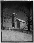 view gallery view galleryN15.9 km |  Our Lady Help of Christians Catholic Church - Weingarten, Missouri Our Lady Help of Christians Catholic Church - Weingarten, Missouri
in Photos Then and Now Catholic church in small German community of Weingarten, Missouri. posted by: BruceS location: Missouri date approved: 05/20/2008 last visited: never |
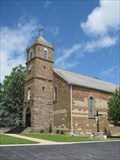 view gallery view galleryN15.9 km |  Our Lady Help of Christians Catholic Church - Weingarten, Missouri Our Lady Help of Christians Catholic Church - Weingarten, Missouri
in This Old Church Catholic church in small German community of Weingarten, Missouri. posted by: BruceS location: Missouri date approved: 05/20/2008 last visited: never |
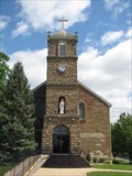 view gallery view galleryN15.9 km | Our Lady Help of Christians Catholic Church - Weingarten, Missouri in Roman Catholic Churches Catholic church in small German community of Weingarten, Missouri. posted by: BruceS location: Missouri date approved: 05/22/2008 last visited: never |
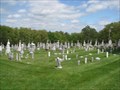
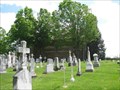 view gallery view galleryN15.9 km |  Our Lady Help of Christians Catholic Church and Cemetery - Weingarten, Missouri Our Lady Help of Christians Catholic Church and Cemetery - Weingarten, Missouri
in Churchyard Cemeteries Catholic church and cemetery in small German community of Weingarten, Missouri. posted by: BruceS location: Missouri date approved: 05/22/2008 last visited: never |
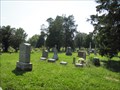
 view gallery view galleryN15.9 km |  Our Lady Help of Christians Catholic Cemetery - Weingarten, Missouri Our Lady Help of Christians Catholic Cemetery - Weingarten, Missouri
in Worldwide Cemeteries Catholic cemetery in small German community of Weingarten, Missouri. posted by: BruceS location: Missouri date approved: 05/20/2008 last visited: never |
 view gallery view gallery S17.4 km S17.4 km
|  Fredericktown Regional Airport - Fredericktown, Missouri Fredericktown Regional Airport - Fredericktown, Missouri
in Airports Fredericktown Regional Airport has a 4000 foot runway, and is located just north of Fredricktown, Missouri. posted by: gparkes location: Missouri date approved: 03/21/2010 last visited: never |
 view gallery view gallery W17.4 km W17.4 km
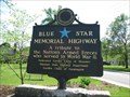
|  Cherokee Trail Park - Farmington, Missouri Cherokee Trail Park - Farmington, Missouri
in Blue Star Memorial Highway Markers Blue Star Memorial marker in a small park on the east side of Farmington. posted by: BruceS location: Missouri date approved: 05/22/2008 last visited: never |
 view gallery view galleryW17.4 km |  Cherokee Trail Roadside Park - Farmington, Missouri Cherokee Trail Roadside Park - Farmington, Missouri
in Trail of Tears Park dedicated to the Cherokee Trail (Trail of Tears) located on east side of Farmington, Missouri.
posted by: BruceS location: Missouri date approved: 05/20/2008 last visited: never |
 view gallery view galleryW17.7 km | Masonic - Calvary Cemetery - Farmington, Missouri in Worldwide Cemeteries Cemetery which is actually two cemeteries in Farmington, Missouri. posted by: BruceS location: Missouri date approved: 09/17/2013 last visited: never |
|