 view gallery view gallery W0.5 km W0.5 km
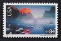
|   Valley View, Yosemite National Park Valley View, Yosemite National Park
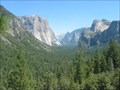
in Philatelic Photographs This classic scene of Yosemite Valley looking east from the valley floor shows El Capitan on the left and Bridal Veil Falls on the right. posted by:  hykesj hykesj location: California date approved: 06/14/2013 last visited: 09/24/2016 |
 view gallery view gallery E0.5 km E0.5 km
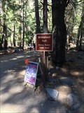
|  Bridalveil Falls Trail - Yosemite, CA Bridalveil Falls Trail - Yosemite, CA
in Hiking and walking trailheads The trailhead for Bridalveil Falls in Yosemite. posted by: bluesnote location: California date approved: 01/14/2017 last visited: 03/12/2022 |
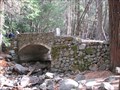 view gallery view galleryE0.6 km |  Yosemite Valley Stone Bridge - Below Bridal Veil Falls Yosemite Valley Stone Bridge - Below Bridal Veil Falls
in Stone Bridges Stone bridge that is now on a pedestrian pathway in Yosemite National Park. posted by: TheBeanTeam location: California date approved: 11/11/2008 last visited: 02/20/2018 |
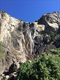
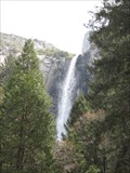 view gallery view galleryE0.8 km |  Bridalveil Fall - Yosemite National Park Bridalveil Fall - Yosemite National Park
in Waterfalls Bridalveil Fall is located at Yosemite National Park. posted by: Mauison location: California date approved: 04/25/2008 last visited: 03/12/2022 |
 view gallery view galleryE0.8 km |  Bridalveil Falls - Yosemite, CA Bridalveil Falls - Yosemite, CA
in Wikipedia Entries Bridalveil Falls is one of the most visited places in the park. posted by: bluesnote location: California date approved: 01/14/2017 last visited: 03/12/2022 |
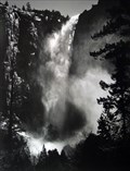 view gallery view galleryE0.8 km |  Bridalveil Falls - Yosemite, CA Bridalveil Falls - Yosemite, CA
in Ansel Adams Photo Hunt Ansel Adams once stood at the base of the falls in 1952 and took some amazing photography of Bridalveil Falls. posted by: bluesnote location: California date approved: 01/13/2017 last visited: 05/07/2023 |
 view gallery view galleryE0.8 km |  Bridalveil Falls - Yosemite, CA Bridalveil Falls - Yosemite, CA
in Official Local Tourism Attractions Bridalveil Falls is one of the most visited places in the park. posted by: bluesnote location: California date approved: 11/08/2017 last visited: 03/12/2022 |
 view gallery view gallery NE1 km NE1 km
|  Merced River Flood 1/2/1997 - (El Capitan) Yosemite, CA Merced River Flood 1/2/1997 - (El Capitan) Yosemite, CA
in High Level Marks Bronze mark in boulder near roadway marks the damaging flood level. posted by: sparkey916 location: California date approved: 08/31/2011 last visited: 02/20/2018 |
 view gallery view galleryW1.8 km |  Rewards of Travel - Yosemite, CA Rewards of Travel - Yosemite, CA
in Signs of History One of a few historical markers at Tunnel View in Yosemite National Park. posted by: bluesnote location: California date approved: 01/13/2017 last visited: 01/25/2019 |
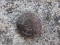
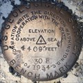
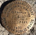 view gallery view galleryW1.8 km |  U.S. Dept. of Agriculture 85+9204 86+2034 Elevation Mark - Yosemite, CA U.S. Dept. of Agriculture 85+9204 86+2034 Elevation Mark - Yosemite, CA
in U.S. Benchmarks This benchmark is located at the best view in the world. posted by: bluesnote location: California date approved: 01/05/2014 last visited: 09/23/2015 |
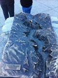 view gallery view galleryW1.8 km |  Tunnel View - Yosemite, CA Tunnel View - Yosemite, CA
in 3D Map Models of Our World and Beyond This map is located at one of the best natural views in the world. posted by: bluesnote location: California date approved: 01/04/2014 last visited: 08/01/2023 |
 view gallery view galleryW1.8 km | Pohono Trail - Yosemite, CA in Hiking and walking trailheads The trailhead to Inspiration point and beyond, from Tunnel View. posted by: bluesnote location: California date approved: 01/14/2017 last visited: 01/14/2017 |
 view gallery view galleryW1.8 km |  John Muir - Tunnel View - Yosemite, CA John Muir - Tunnel View - Yosemite, CA
in Etched in Stone Located on the, "A Varied View" plaque. posted by: bluesnote location: California date approved: 02/18/2017 last visited: 02/18/2017 |
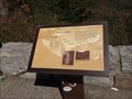
 view gallery view galleryW1.8 km |  A Varied View - Yosemite, CA A Varied View - Yosemite, CA
in Orientation Tables One of a few historical markers at Tunnel View in Yosemite National Park. posted by: bluesnote location: California date approved: 01/17/2017 last visited: 01/17/2017 |
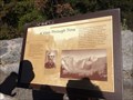
 view gallery view galleryW1.8 km | A View Through Time - Yosemite, CA in Signs of History One of a few historical markers at Tunnel View in Yosemite National Park. posted by: bluesnote location: California date approved: 01/13/2017 last visited: 06/29/2018 |
 view gallery view galleryW1.8 km | Lafayette Bunnell - Tunnel View - Yosemite, CA in Etched in Stone Located on the "A View Through Time" plaque. posted by: bluesnote location: California date approved: 01/13/2017 last visited: 01/13/2017 |
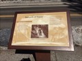
 view gallery view galleryW1.8 km |  FIRST -- Euro-Americans to Enter Yosemite Valley - Yosemite, CA FIRST -- Euro-Americans to Enter Yosemite Valley - Yosemite, CA
in First of its Kind Located on the "A View Through Time" plaque. posted by: bluesnote location: California date approved: 01/13/2017 last visited: 01/13/2017 |
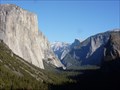
 view gallery view galleryW1.8 km |  Scenic Roadside Look-Out: Discovery View, Yosemite National Park Scenic Roadside Look-Out: Discovery View, Yosemite National Park
in Scenic Roadside Look-Outs Discovery View in Yosemite National Park just outside of the Wawona Tunnel. posted by: 50sumtin location: California date approved: 08/14/2006 last visited: 08/01/2023 |
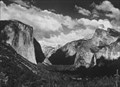 view gallery view galleryW1.8 km | Ansel Adams Photo Hunt: YOSEMITE VALLEY, YOSEMITE NATIONAL PARK, SUMMER, CALIFORNIA, ca. 1935. in Ansel Adams Photo Hunt Inspiration Point, also known as Discovery View, in Yosemite National Park, California posted by: 50sumtin location: California date approved: 08/13/2006 last visited: 05/03/2022 |
 view gallery view galleryW1.8 km | Tunnel View - Yosemite, CA in Wikipedia Entries One of the best views of the natural world. posted by: bluesnote location: California date approved: 02/07/2014 last visited: 07/07/2017 |
 view gallery view galleryW1.8 km | Tunnel View - Yosemite, CA in Official Local Tourism Attractions One of the best views of the natural world. posted by: bluesnote location: California date approved: 11/08/2017 last visited: 08/01/2023 |
 view gallery view galleryW1.8 km | U.S. Geological Survey 30B Benchmark - Yosemite, CA in U.S. Benchmarks A benchmark at the east end of the tunnel into Yosemite Valley on Highway 41 from Fresno. posted by: bluesnote location: California date approved: 10/10/2016 last visited: 10/10/2016 |
 view gallery view galleryE2.1 km |  Mother of famed climber summits El Capitan to celebrate turning 70 Mother of famed climber summits El Capitan to celebrate turning 70
in News Article Locations A story about the ascent of El Capitan. posted by: saopaulo1 location: California date approved: 03/02/2022 last visited: never |
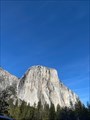
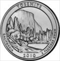 view gallery view galleryNE2.4 km |  El Capitan - Yosemite, CA El Capitan - Yosemite, CA
in Numismatic Photographs El Capitan in Yosemite National Park is also on the back of the U.S. Quarter. posted by: bluesnote location: California date approved: 01/05/2014 last visited: 11/10/2015 |
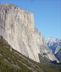 view gallery view galleryNE2.4 km |  El Capitan - Yosemite, CA El Capitan - Yosemite, CA
in Satellite Imagery Oddities El Capitan in Yosemite National Park. posted by: bluesnote location: California date approved: 01/11/2017 last visited: 08/01/2023 |
|