 view gallery view gallery W4 km W4 km
|   Hinton WV 25951 Post Office Hinton WV 25951 Post Office
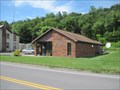
in U.S. Post Offices Hinton WV, Post Office posted by:  dukemartin dukemartin location: West Virginia date approved: 09/25/2017 last visited: 04/22/2024 |
 view gallery view galleryW4.2 km |  Chesapeake & Ohio RR station - Hinton, West Virginia Chesapeake & Ohio RR station - Hinton, West Virginia
in Train Stations/Depots The Hinton Station is located at 100 2nd Ave at Maple Ave. It was built in 1913 for the C&O Railroad. It currently serves Amtrak's Cardinal. posted by: buffalohiker location: West Virginia date approved: 11/06/2019 last visited: 04/22/2024 |
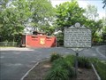
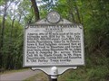
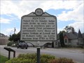 view gallery view galleryW4.2 km |  Hinton Hinton
in West Virginia Historical Markers A short history of the Hinton WV area. posted by: dukemartin location: West Virginia date approved: 09/18/2017 last visited: 09/18/2017 |
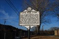
 view gallery view gallery SW4.3 km SW4.3 km
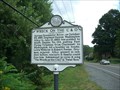
| The Wreck on the C&O in West Virginia Historical Markers WV 3, 0.8 miles from junction with WV 3/WV 20, Hinton, WV. This is near the intersection of Hwy 3 and Pine St. posted by:  fatcat161 fatcat161 location: West Virginia date approved: 09/02/2009 last visited: 09/17/2017 |
 view gallery view gallerySW4.3 km |  "Fatal Run" - Cliff Carlisle "Fatal Run" - Cliff Carlisle
in Immortalized in Lyrics WV 3, 0.8 miles from junction with WV 3/WV 20, Hinton, WV. This is near the intersection of Hwy 3 and Pine St.
posted by: fatcat161 location: West Virginia date approved: 08/26/2009 last visited: 09/17/2017 |
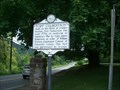 view gallery view gallerySW4.7 km | Fort Culbertson in West Virginia Historical Markers Greenbrier Drive (WV 3) East and Cedar Avenue, 2.0 miles west of the WV 12 split, 2 blocks east of WV 107 posted by: fatcat161 location: West Virginia date approved: 09/02/2009 last visited: 09/17/2017 |
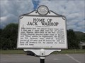 view gallery view gallerySW5.3 km | Home of Jack Warhop in West Virginia Historical Markers Babe Ruth's first two major league home runs were hit off of this pitcher. posted by: dukemartin location: West Virginia date approved: 09/18/2017 last visited: 09/18/2017 |
 view gallery view gallerySW5.6 km |  Bluestone Dam - Hinton, WV Bluestone Dam - Hinton, WV
in Fishing Holes Fishing spot is near the end of Miller Ave in Hinton, WV. posted by: fatcat161 location: West Virginia date approved: 11/17/2009 last visited: 04/22/2024 |
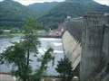 view gallery view gallerySW5.8 km |  Bluestone Dam - Hinton WV Bluestone Dam - Hinton WV
in Water Dams Spanning the New River at Hinton the dam forms Bluestone Lake, the third largest lake in West Virginia. posted by: fatcat161 location: West Virginia date approved: 08/26/2009 last visited: 04/22/2024 |
 view gallery view gallery SE7.7 km SE7.7 km
| Big Bend Tunnel in West Virginia Historical Markers Big Bend Tunnel posted by: VQ9JC location: West Virginia date approved: 08/26/2013 last visited: 06/29/2022 |
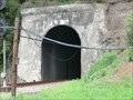 view gallery view gallerySE7.9 km | ") Big Bend Tunnel - Talcott W V Big Bend Tunnel - Talcott W V
in Cave Entrances (Artificial) The great tunnel of the C & O Railroad was started at Big Bend in 1870 and completed three years later. Tradition makes this the scene of the steel drivers' ballad, "John Henry" made popular by John Cash. posted by: Don.Morfe location: West Virginia date approved: 07/05/2022 last visited: 06/29/2022 |
 view gallery view gallery E9 km E9 km
| Talcott WV Post Office - 24981 in U.S. Post Offices This post office is located on SR 3 West near the Talcott Public Access Site to the Greenbrier River on Barger Spring Rd. Talcott is in Summers County. The John Brown Historical Site is a short distance to the west; see Waymark WMHWX3. posted by: VQ9JC location: West Virginia date approved: 08/25/2013 last visited: never |
 view gallery view gallerySW9.8 km |  Bluestone National Scenic River - Hinton WV Bluestone National Scenic River - Hinton WV
in National Wild and Scenic Rivers The lower 10 miles of the designated segment flow through an 800-foot deep gorge and offer warmwater fishing, whitewater boating when water level permits, and hiking along the river on a trail between Bluestone and Pipestem State Parks. posted by: Don.Morfe location: West Virginia date approved: 12/28/2020 last visited: 04/22/2024 |
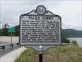 view gallery view gallerySW10.1 km | Pack's Ferry in West Virginia Historical Markers A short Civil War battle occurred here. posted by: dukemartin location: West Virginia date approved: 08/14/2017 last visited: 04/22/2024 |
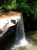 view gallery view gallerySW10.5 km |  Almost Hidden Waterfall -- Bluestone State Park Almost Hidden Waterfall -- Bluestone State Park
in Waterfalls A small, nearly hidden waterfall in Bluestone State Park in West Virginia. posted by: Deweyz location: West Virginia date approved: 06/23/2006 last visited: 04/03/2019 |
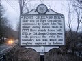 view gallery view galleryE10.6 km | Fort Greenbrier in West Virginia Historical Markers A sign telling us who commanded Fort Greenbrier. posted by: Paintedwarrior location: West Virginia date approved: 01/13/2016 last visited: 01/13/2016 |
 view gallery view gallerySW10.9 km | Giles, Fayette & Kanawha Turnpike in West Virginia Historical Markers A quick,description of the route of the turnpike. posted by: dukemartin location: West Virginia date approved: 09/18/2017 last visited: 09/18/2017 |
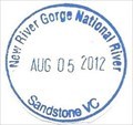 view gallery view gallery N12.1 km N12.1 km
|  New River Gorge National River-Sandstone New River Gorge National River-Sandstone
in NPS Passport Cancellation Stations The New River is like a ribbon tying together all the people, places, and events sharing its course through time. posted by: Don.Morfe location: West Virginia date approved: 12/27/2019 last visited: 04/22/2024 |
 view gallery view galleryN12.1 km | ") New River Gorge National River-Sandstone New River Gorge National River-Sandstone
in National Parks (U.S.) The New River is like a ribbon tying together all the people, places, and events sharing its course through time. posted by: Don.Morfe location: West Virginia date approved: 12/27/2019 last visited: 04/22/2024 |
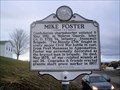 view gallery view gallery S13.2 km S13.2 km
| Mike Foster in West Virginia Historical Markers A sign telling us of the battles Mike Foster fought in. posted by: Paintedwarrior location: West Virginia date approved: 01/13/2016 last visited: 01/13/2016 |
 view gallery view galleryS13.4 km | Civil War Camp in West Virginia Historical Markers Along WV 12 in front of Forest Hill United Methodist Church posted by: bitmapped location: West Virginia date approved: 02/12/2010 last visited: 01/13/2016 |
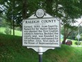 view gallery view galleryW14.2 km | Raleigh County/Summers County in West Virginia Historical Markers Located on Hwy 3 near Walnut Ln in Jumping Branch, WV posted by: fatcat161 location: West Virginia date approved: 09/02/2009 last visited: 05/26/2017 |
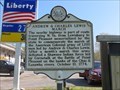 view gallery view galleryN14.5 km | Andrew & Charles Lewis March in West Virginia Historical Markers A quick description of the trail by Andrew & Charles Lewis plus the battle they fought at Point Pleasant. posted by: dukemartin location: West Virginia date approved: 05/16/2018 last visited: 05/16/2018 |
 view gallery view galleryN14.6 km | Green Sulphur Springs WV Post Office - 25966 in U.S. Post Offices The GPS coords for this post office are correct and is on SR 20, a short distance off Exit 143 to the north of I-64. The USPS's on-line Location link shows this P.O. is past Exit 139 near the New River, more than 4 miles away from where it really is. posted by: VQ9JC location: West Virginia date approved: 08/25/2013 last visited: 05/09/2018 |
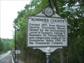 view gallery view galleryS16.6 km | Monroe County/Summers County in West Virginia Historical Markers Located just north of Red Sulphur Marie (CR21/4) on Hwy 12 at the county line. posted by: fatcat161 location: West Virginia date approved: 09/02/2009 last visited: 01/13/2016 |
|