 view gallery view gallery SE10.5 km SE10.5 km
|   McDonalds - Jackson, KY McDonalds - Jackson, KY
in McDonald's Restaurants This McDonalds is located in Jackson, Kentucky, on Route 15, and features a large enclosed play area. posted by:  silverquill silverquill location: Kentucky date approved: 05/12/2008 last visited: never |
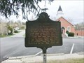
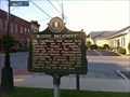 view gallery view gallerySE11.9 km |  "Bloody Breathitt" "Bloody Breathitt"
in Kentucky Historical Markers Out caching and found this sign posted by: geoprof123 location: Kentucky date approved: 07/09/2012 last visited: 07/03/2011 |
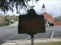
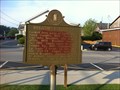 view gallery view gallerySE11.9 km | Breathitt County in Kentucky Historical Markers Out caching and seen this sign posted by: geoprof123 location: Kentucky date approved: 07/09/2012 last visited: 07/03/2011 |
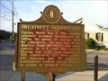 view gallery view gallerySE11.9 km | Breathitt Volunteers in Kentucky Historical Markers Out caching and seen this sign posted by: geoprof123 location: Kentucky date approved: 07/09/2012 last visited: 07/03/2011 |
 view gallery view gallery NW12.7 km NW12.7 km
|  Campton, KY Campton, KY
in City and Town Halls This is the city hall for the small town of Campton, Kentucky. posted by: silverquill location: Kentucky date approved: 05/03/2008 last visited: never |
 view gallery view galleryNW12.7 km |  The Friendliest Town in the Mountains - Campton, KY The Friendliest Town in the Mountains - Campton, KY
in Welcome Signs This Welcome sign is at the city hall for the small town of Campton, Kentucky, in the mountains of Wolfe County. posted by: silverquill location: Kentucky date approved: 05/03/2008 last visited: 10/23/2012 |
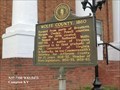
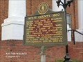
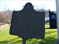
 view gallery view galleryNW12.9 km | Gateway to Appalachia-Campton, KY in Kentucky Historical Markers Wolfe County, founded in 1860, is Eastern Kentucky’s Gateway to Appalachia. The National Designated Wild and Scenic Red River and the North Fork of the Kentucky River flow through Wolfe County. posted by:  Don.Morfe Don.Morfe location: Kentucky date approved: 12/04/2020 last visited: 10/20/2021 |
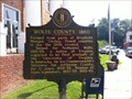 view gallery view galleryNW12.9 km | Wolfe County, 1860 in Kentucky Historical Markers Interesting information to learn on a visit to the court house. posted by: geoprof123 location: Kentucky date approved: 07/17/2011 last visited: 11/23/2022 |
 view gallery view galleryNW12.9 km |  Nathaniel Wolfe - Compton KY Nathaniel Wolfe - Compton KY
in Citizen Memorials Nathaniel Wolfe-Member of the House of Representatives of the Commonwealth of Kentucky from Louisville from 1859 to 1863. Owned three enslaved persons in Louisville in 1860. posted by: Don.Morfe location: Kentucky date approved: 11/23/2022 last visited: 11/23/2022 |
 view gallery view galleryNW12.9 km |  Nathaniel Wolfe - Compton KY Nathaniel Wolfe - Compton KY
in Civil Rights Memorials Nathaniel Wolfe-Member of the House of Representatives of the Commonwealth of Kentucky from Louisville from 1859 to 1863. Owned three enslaved persons in Louisville in 1860. posted by: Don.Morfe location: Kentucky date approved: 11/23/2022 last visited: 11/23/2022 |
 view gallery view galleryNW12.9 km |  Wolfe County - Compton KY Wolfe County - Compton KY
in People-Named Places Wolfe County KY was named after Nathaniel Wolfe. In Kentucky, he was Commonwealth's Attorney for Jefferson County for 13 years, 1839-52. Member of State legislature, 1853-55, 1859-63. posted by: Don.Morfe location: Kentucky date approved: 11/24/2022 last visited: 11/23/2022 |
 view gallery view galleryNW13 km | Swift's Silver Camp in Kentucky Historical Markers Many people have spent fortunes looking for all that silver only to be disappointed. This is a piece of local lore/history that is fun too learn. posted by: geoprof123 location: Kentucky date approved: 07/17/2011 last visited: 11/23/2022 |
 view gallery view galleryNW13 km | USA Gens. Morgan CSA /Confederate Raids and Invasions, and a Federal Retreat, in Kentucky - Compton, KY in Kentucky Historical Markers Gen. George W. Morgan's 9,000 USA force, cut off from supplies at Cumberland Gap, retreated 200 mi. in 16 days to Greenup on Ohio R. Passed near here Sept. 23, 1862. posted by: Don.Morfe location: Kentucky date approved: 03/25/2020 last visited: 10/20/2021 |
 view gallery view galleryNW13 km |  Battle of Mount Sterling - Mount Sterling KY Battle of Mount Sterling - Mount Sterling KY
in Battlefields The Battle of Mount Sterling was a minor action in the American Civil War that occurred in June 1864 in Mount Sterling, Kentucky. posted by: Don.Morfe location: Kentucky date approved: 11/08/2020 last visited: 10/17/2021 |
 view gallery view galleryNW13 km | USA Gens. Morgan CSA /Confederate Raids and Invasions, and a Federal Retreat, in Kentucky - Compton, KY in Battlefields Gen. George W. Morgan's 9,000 USA force, cut off from supplies at Cumberland Gap, retreated 200 mi. in 16 days to Greenup on Ohio R. Passed near here Sept. 23, 1862. posted by: Don.Morfe location: Kentucky date approved: 09/18/2022 last visited: 09/17/2022 |
 view gallery view gallerySE15.6 km | Quicksand-1864 in Kentucky Historical Markers Site of Civil War Skirmish, April, 1864. posted by: Wallyum location: Kentucky date approved: 03/26/2011 last visited: never |
 view gallery view gallery NE15.8 km NE15.8 km
|  Daniel Noble-Gillmore, KY Daniel Noble-Gillmore, KY
in Medal Of Honor Resting Places Civil War Medal of Honor Recipient for action on board the USS Metacomet during the rescue of the US Monitor Tecumseh in Mobile Bay, AL on August 5, 1864. He is buried in Childers Cemetery, Gillmore, KY. posted by: Don.Morfe location: Kentucky date approved: 01/21/2019 last visited: 12/06/2021 |
 view gallery view galleryNW16.9 km |  Creation Falls - Red River Gorge geological area, KY, US Creation Falls - Red River Gorge geological area, KY, US
in Waterfalls Rock Bridge Loop Trail #207
Clifty Wilderness, Red River Gorge, Kentucky posted by: Crazy4horses location: Kentucky date approved: 04/28/2016 last visited: 04/29/2016 |
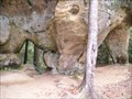
 view gallery view galleryNW17.2 km | ") Rockhouse- Red River Gorge Geological Area - KY, US Rockhouse- Red River Gorge Geological Area - KY, US
in Cave Entrances (Natural) Rockhouse (rockshelter) is located right on Rock Bridge Trail #207 posted by: Crazy4horses location: Kentucky date approved: 01/05/2017 last visited: 01/05/2017 |
 view gallery view galleryNW17.2 km |  Rock Bridge Trail #207 - Red River Gorge Gelogical Area, KY, US Rock Bridge Trail #207 - Red River Gorge Gelogical Area, KY, US
in Scenic Hikes From Slade, take KY 15 east for 7 miles to KY 715. Turn left on 715 and go 0.3-mile and turn right onto Rock Bridge Road. Follow this road for 3 miles to its ends at the Rock Bridge Picnic Area. posted by: Crazy4horses location: Kentucky date approved: 05/21/2016 last visited: 05/18/2016 |
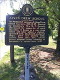 view gallery view galleryNW18.7 km | Alvan Drew School in Kentucky Historical Markers It is fun to stand there and imagine what it was like for all those kids going to school there. This was a neat stop on the way to Red River George. posted by: geoprof123 location: Kentucky date approved: 07/17/2011 last visited: 07/03/2011 |
 view gallery view galleryNW21.2 km | Angel Windows in Natural Arches Angel Windows arches posted by: KyWildturkey location: Kentucky date approved: 11/01/2005 last visited: 08/01/2011 |
 view gallery view galleryNW21.6 km | Silvermine Arch - Red River Gorge Geologic Area, KY, US in Natural Arches Located on Silvermine Arch Trail #225 posted by: Crazy4horses location: Kentucky date approved: 01/01/2017 last visited: 01/01/2017 |
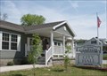
 view gallery view gallery W21.6 km W21.6 km
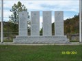
|  Lee County War Memorial - Beattyville, KY Lee County War Memorial - Beattyville, KY
in Non-Specific Veteran Memorials Lee County War Memorial, Beattyville, KY posted by: hummerstation location: Kentucky date approved: 11/16/2011 last visited: 11/07/2020 |
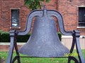 view gallery view galleryW21.9 km |  Lee County Courthouse Bell - Beattyville, KY Lee County Courthouse Bell - Beattyville, KY
in Bells Lee County Courthouse Bell, Beattyville, KY posted by: hummerstation location: Kentucky date approved: 11/06/2011 last visited: 12/15/2011 |
|