  E8 km E8 km
|   Lodestar Lightning Lodestar Lightning
in Plane Crash Sites In 1977 a Lockheed Lodestar, laden with tons of marijuana, crashed at Lower Merced Pass Lake in the remote backcountry of Yosemite National Park. The incident in 1977 was the inspiration for Nevada Barr's national best selling book, "High Country". The true story is almost stranger than fiction. posted by:  Touchstone Touchstone location: California date approved: 03/04/2006 last visited: never |
 view gallery view gallery SW11.1 km SW11.1 km
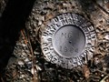
|  Mariposa Grove Museum Mariposa Grove Museum
in U.S. Benchmarks The mark is located next to the Maripose Grove Museum in Yosemite National Park. posted by:  ltleelim ltleelim location: California date approved: 01/28/2006 last visited: 10/08/2022 |
 view gallery view gallery W11.7 km W11.7 km
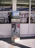
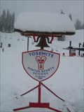
|  Yosemite Badger Pass Penny Smasher (Gone) Yosemite Badger Pass Penny Smasher (Gone)
in Penny Smashers This penny smasher is located at Badger Pass Ski Area in Yosemite National Park. The ski area itself is open from about late November to about the end of March. This Penny Smasher has been permanently removed from this location. posted by: Touchstone location: California date approved: 01/17/2007 last visited: 08/12/2012 |
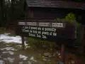 view gallery view gallerySW12.6 km |  Pioneer Yosemite History Center - Wawona, California Pioneer Yosemite History Center - Wawona, California
in Self Guided Walks and Trails The Pioneer Yosemite History Center at Wawona in Yosemite National Park has this short self guided walk amongst some relocated historic buildings. posted by: Touchstone location: California date approved: 01/27/2009 last visited: 04/20/2010 |
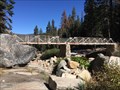
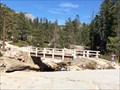
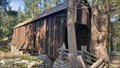 view gallery view gallerySW12.6 km |  Wawona Covered Bridge - Wawona, CA Wawona Covered Bridge - Wawona, CA
in U.S. National Register of Historic Places Over the South Fork of the Merced River in Wawona is a covered bridge. There are only a dozen covered bridges in California, which is reason enough that this bridge is special. But this bridge is special for a whole host of other reasons posted by: T-Team! location: California date approved: 05/07/2022 last visited: 08/17/2022 |
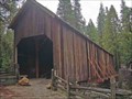 view gallery view gallerySW12.6 km |  Wawona Covered Bridge - Yosemite National Park, California Wawona Covered Bridge - Yosemite National Park, California
in Covered Bridges The original deck of the bridge was layed by Galen Clark in or around 1857. posted by: Touchstone location: California date approved: 01/27/2009 last visited: 05/03/2022 |
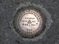
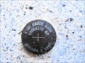
 view gallery view gallerySW12.7 km | U.S. Dept. of the Interior MG1 1984 Mark - Fish Camp, CA in U.S. Benchmarks This mark is located at the parking lot for the Mariposa Grove Trees in Yosemite National Park. posted by: bluesnote location: California date approved: 01/05/2014 last visited: 01/05/2014 |
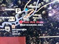 view gallery view gallerySW12.7 km |  Mariposa Grove Map - Yosemite, CA Mariposa Grove Map - Yosemite, CA
in 'You Are Here' Maps This is one of many maps inside the park. posted by: bluesnote location: California date approved: 01/04/2014 last visited: 01/04/2014 |
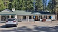 view gallery view gallerySW12.7 km |  Wawona, CA, 95389 Wawona, CA, 95389
in U.S. Post Offices In Yosemite National Park there are not many part offices.. but this one im Wawona is one of them. The post office is in the general store which (besides to the post office) also has gifts, snacks and drinks. posted by: T-Team! location: California date approved: 05/06/2022 last visited: never |
 view gallery view gallery N12.7 km N12.7 km
|  Illilouette Creek Bridge - Yosemite, CA Illilouette Creek Bridge - Yosemite, CA
in Hiking Path Footbridges A bridge along a trail about 1.5 miles from Glacier Point. posted by: bluesnote location: California date approved: 01/11/2017 last visited: 01/11/2017 |
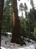 view gallery view gallerySW12.9 km |  Make Yourself Look Tiny Make Yourself Look Tiny
in Photo Goals Make yourself look tiny by standing next to something HUGE! posted by: bluesnote location: California date approved: 09/09/2010 last visited: 02/17/2023 |
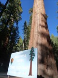
 view gallery view gallerySW12.9 km |  Mariposa Grove - Fish Camp, CA Mariposa Grove - Fish Camp, CA
in American Guide Series Mariposa Grove is part of Yosemite National Park. posted by: bluesnote location: California date approved: 03/20/2016 last visited: 03/20/2016 |
 view gallery view gallerySW12.9 km |  Mariposa Grove - Fish Camp, CA Mariposa Grove - Fish Camp, CA
in Official Local Tourism Attractions Mariposa Grove is part of Yosemite National Park. posted by: bluesnote location: California date approved: 11/08/2017 last visited: 11/08/2017 |
 view gallery view gallerySW12.9 km |  Mariposa Grove - Fish Camp, CA Mariposa Grove - Fish Camp, CA
in Wikipedia Entries Mariposa Grove is part of Yosemite National Park. posted by: bluesnote location: California date approved: 02/15/2014 last visited: 01/26/2015 |
 view gallery view gallerySW13.4 km |  Stop Sign - Fish Camp, CA Stop Sign - Fish Camp, CA
in Solar Power This stop sign is on the road from Mariposa Grove to Yosemite Valley, at the entrance gate. posted by: bluesnote location: California date approved: 02/09/2014 last visited: 02/09/2014 |
 view gallery view gallery NW13.4 km NW13.4 km
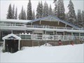
|  Badger Pass Ski Lodge - Yosemite National Park, California Badger Pass Ski Lodge - Yosemite National Park, California
in Ski Lodges The Ski Lodge at Badger Pass Ski Area is the first and oldest ski lodge in California. posted by: Touchstone location: California date approved: 01/27/2009 last visited: never |
 view gallery view galleryNW13.4 km |  Yosemite Ski School Bell - Badger Pass Ski Area, California Yosemite Ski School Bell - Badger Pass Ski Area, California
in Bells A seasonal bell which the Yosemite Ski School uses to call students for ski/snowboard lessons. posted by: Touchstone location: California date approved: 01/27/2009 last visited: never |
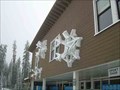 view gallery view galleryNW13.4 km |  Badger Pass Snowflakes - Yosemite National Park, California Badger Pass Snowflakes - Yosemite National Park, California
in 3 Dimensional Art These larger than life snowflakes adorn the outside wall of the ski lodge. posted by: Touchstone location: California date approved: 01/26/2009 last visited: never |
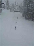 view gallery view galleryNW13.4 km |  Badger Pass - Yosemite National Park, California Badger Pass - Yosemite National Park, California
in Winter Sports Locations Badger Pass is the oldest ski area in California and offers intermediate to beginner slopes for skiers and snowboarders. posted by: Touchstone location: California date approved: 01/26/2009 last visited: 01/25/2019 |
 view gallery view galleryN13.4 km | Benchmark: Yosemite's Happy Isles' Split Rock in U.S. Benchmarks Elevation benchmark at Yosemite's Happy Isles posted by: 50sumtin location: California date approved: 05/07/2006 last visited: 11/02/2017 |
 view gallery view galleryN13.4 km |  Merced River Flood 1/2/1997 - Yosemite, CA Merced River Flood 1/2/1997 - Yosemite, CA
in High Level Marks Bronze mark in boulder near river gauging station marks the damaging flood level posted by: hotshoe location: California date approved: 09/17/2010 last visited: 02/20/2018 |
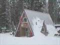 view gallery view galleryNW13.4 km |  Badger Pass Ranger Station - Yosemite National Park, California Badger Pass Ranger Station - Yosemite National Park, California
in Ranger Stations The Badger Pass Ranger Station, or as it is commonly known, the "A Frame", is the place for winter travelers heading out to the backcountry. posted by: Touchstone location: California date approved: 01/26/2009 last visited: never |
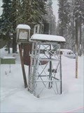 view gallery view galleryNW13.4 km |  Badger Pass Weatherstation - Yosemite National Park, California Badger Pass Weatherstation - Yosemite National Park, California
in Weather Stations This weather station sits adjacent to the Badger Pass Ranger Station at the Badger Pass Ski Area in Yosemite National Park, California. posted by: Touchstone location: California date approved: 01/27/2009 last visited: never |
 view gallery view galleryN14 km | Nevada Falls Bridge - Yosemite, CA in Hiking Path Footbridges About 5 miles from Glacier Point, 4 miles from Curry Village, and 9 miles form Half Dome. posted by: bluesnote location: California date approved: 01/11/2017 last visited: 01/11/2017 |
 view gallery view galleryN14 km | Nevada Falls - Yosemite, CA in Wikipedia Entries An extremely challenging hike to get here, but very rewarding once you see it in person. posted by: bluesnote location: California date approved: 01/14/2017 last visited: 01/14/2017 |
|