 view gallery view gallery W5.5 km W5.5 km
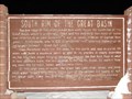
|   South Rim of the Great Basin South Rim of the Great Basin
in Utah Historical Markers The low ridge at the south end of This valley forms the south rim of the Great Basin, which in prehistoric times was the bed of a vast body of water now referred to as Lake Bonneville.
posted by:  JacobBarlow JacobBarlow location: Utah date approved: 01/13/2008 last visited: 08/23/2019 |
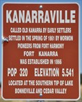
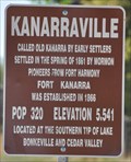 view gallery view galleryW7.2 km |  Kanarraville, Utah ~ Population 320 Kanarraville, Utah ~ Population 320
in Population Signs Kanarraville claims that they had the only all-female fire department from 1961 to 1968. posted by: brwhiz location: Utah date approved: 04/05/2012 last visited: never |
 view gallery view galleryW7.2 km |  Kanarraville, Utah ~ Elevation 5541 feet Kanarraville, Utah ~ Elevation 5541 feet
in Elevation Signs Kanarraville is one of many rural towns in Utah where the altitude far exceeds the population. posted by: brwhiz location: Utah date approved: 04/05/2012 last visited: never |
 view gallery view gallery N7.4 km N7.4 km
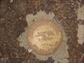
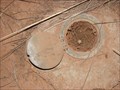
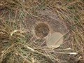
|  Benchmark: HO0210 " H 28 " Benchmark: HO0210 " H 28 "
in U.S. Benchmarks A very nice Benchmark we came across, just off the frontage road, south of Cedar City. posted by: JacobBarlow location: Utah date approved: 10/18/2007 last visited: 10/18/2007 |
 view gallery view galleryN7.4 km | Benchmark: HO0477 " B 376 " in U.S. Benchmarks We found this just off the frontage road south of Cedar City. posted by: JacobBarlow location: Utah date approved: 10/18/2007 last visited: 05/27/2014 |
 view gallery view galleryW7.7 km |  Kanarraville, Utah 84742 Kanarraville, Utah 84742
in U.S. Post Offices This Post Office is located at 65 E Center Street in Kanarraville, Utah. posted by: brwhiz location: Utah date approved: 11/09/2011 last visited: 01/12/2012 |
 view gallery view galleryW7.7 km |  First Birth in Kanarraville, Utah First Birth in Kanarraville, Utah
in First of its Kind The first child born in Kanarraville was the son of the blacksmith. posted by: brwhiz location: Utah date approved: 04/05/2012 last visited: never |
 view gallery view galleryW7.7 km | First LDS Bishop of Kanarraville, Utah in First of its Kind Lorenzo W. Roundy was the first Bishop of Kanarraville. posted by: brwhiz location: Utah date approved: 04/05/2012 last visited: never |
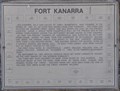
 view gallery view galleryW7.7 km | Fort Kanarra in Utah Historical Markers Fort Kanarra, or Old Kanarra, was founded in 1861 by settlers from nearby Fort Harmony. posted by: brwhiz location: Utah date approved: 04/05/2012 last visited: never |
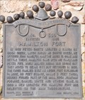 view gallery view galleryN7.9 km |  Hamilton Fort ~ 309 Hamilton Fort ~ 309
in D.U.P. Historic Markers Hamilton Fort was built for protection from Indians but was later moved to a new location. posted by: brwhiz location: Utah date approved: 01/21/2012 last visited: 04/18/2023 |
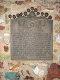 view gallery view galleryN7.9 km | Hamilton Fort in Utah Historical Markers In 1852 Peter Shirts located a ranch on Sidon Creek, later known as Shirts Creek. He offered John Hamilton half the water to come and settle there.... posted by: JacobBarlow location: Utah date approved: 10/25/2007 last visited: 04/18/2023 |
 view gallery view gallery SW8.2 km SW8.2 km
| Kanarraville, Utah ~ Elevation 5541 feet in Elevation Signs Kanarraville is one of many rural towns in Utah where the altitude far exceeds the population. posted by: brwhiz location: Utah date approved: 04/05/2012 last visited: never |
 view gallery view gallerySW8.2 km | Kanarraville, Utah ~ Population 320 in Population Signs Kanarraville claims that they had the only all-female fire department from 1961 to 1968. posted by: brwhiz location: Utah date approved: 04/05/2012 last visited: never |
 view gallery view galleryN8.7 km | Benchmark: HO0476 " C 376 " in U.S. Benchmarks Easy to find, right off the Frontage road south of Cedar City. posted by: JacobBarlow location: Utah date approved: 10/18/2007 last visited: 01/02/2023 |
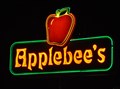 view gallery view galleryN10.3 km |  Applebees, Providence Center - Cedar City, Utah Applebees, Providence Center - Cedar City, Utah
in Neon Signs Typical neon signage at most Applebee's locations. posted by: brwhiz location: Utah date approved: 03/09/2011 last visited: 08/29/2014 |
 view gallery view galleryN10.3 km |  Applebees, Providence Center - Cedar City, Utah Applebees, Providence Center - Cedar City, Utah
in Applebee's Restaurants A relatively new Applebee's in the Providence Center on Interstate 15 at Exit 57. posted by: brwhiz location: Utah date approved: 03/09/2011 last visited: 06/21/2019 |
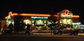
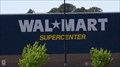 view gallery view galleryN10.3 km |  Wal-Mart Supercenter - Cedar City, Utah Wal-Mart Supercenter - Cedar City, Utah
in WAL*MART Stores Wal-Mart Supercenter with a McDonald's at the south end of Cedar City, UT posted by: nvtriker location: Nevada date approved: 05/18/2009 last visited: 08/05/2014 |
 view gallery view galleryN10.3 km | Benchmark: HO0475 " D 376 " in U.S. Benchmarks Just off the road in town in Cedar City. posted by: JacobBarlow location: Utah date approved: 10/17/2007 last visited: 05/27/2014 |
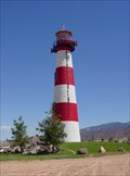 view gallery view galleryN10.3 km |  Providence Providence
in Landlocked Lighthouses A nice lighthouse in the middle of the desert. posted by: TonyGlo location: Utah date approved: 09/25/2005 last visited: 08/24/2019 |
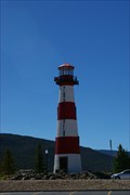 view gallery view galleryN10.3 km |  Providence Lighthouse - UT Providence Lighthouse - UT
in Roadside Attractions Providence Lighthouse - UT posted by: kJfishman location: Utah date approved: 02/22/2011 last visited: 08/24/2019 |
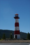 view gallery view galleryN10.3 km |  TALLEST - Inland Lighthouse TALLEST - Inland Lighthouse
in Superlatives Tallest--Inland Lighthouse The lighthouse is ninety feet tall and at a 5,236 foot elevation it is the tallest inland lighthouse. posted by: kJfishman location: Utah date approved: 02/22/2011 last visited: 08/24/2019 |
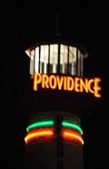 view gallery view galleryN10.3 km | Providence Center - Cedar City, Utah in Neon Signs The neon on this lighthouse advertises the Providence Shopping Center at the south end of Cedar City. posted by: brwhiz location: Utah date approved: 03/09/2011 last visited: 08/24/2019 |
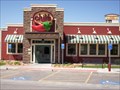 view gallery view galleryN10.5 km |  Chili's - Cedar City, Utah Chili's - Cedar City, Utah
in Chili's Restaurants Chili's is on the west side of I-15 at the south end of town. posted by: nvtriker location: Utah date approved: 05/18/2009 last visited: 08/24/2019 |
 view gallery view galleryN10.5 km | Panda Express - Cedar City, Utah in Neon Signs Neon signs at the only Panda Express in Cedar City. posted by: brwhiz location: Utah date approved: 03/09/2011 last visited: 08/05/2014 |
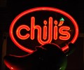 view gallery view galleryN10.5 km | Chili's - Cedar City, Utah in Neon Signs The neon sign for the Chili's restaurant in the Providence Center in Cedar City, Utah. posted by: brwhiz location: Utah date approved: 03/09/2011 last visited: 08/24/2019 |
|