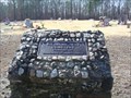
 view gallery view gallery S15.9 km S15.9 km
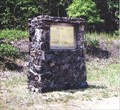
|   Pilgrims Rest Cemetery, Shannondale, Shannon Co., Missouri Pilgrims Rest Cemetery, Shannondale, Shannon Co., Missouri
in Worldwide Cemeteries Pilgrims Rest Cemetery, Shannondale Shannon Co., Missouri. Est. 1952. 140 graves. posted by:  Headstone Hunter 1 Headstone Hunter 1 location: Missouri date approved: 08/25/2007 last visited: 08/25/2007 |
 view gallery view gallery NW16.1 km NW16.1 km
|  Salem, Missouri - Population - 4,950 Salem, Missouri - Population - 4,950
in Population Signs South city limits.... posted by: YoSam. location: Missouri date approved: 03/02/2020 last visited: never |
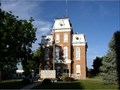 view gallery view galleryNW16.9 km |  Dent County Courthouse Dent County Courthouse
in U.S. National Register of Historic Places Dent County Courthouse in Salem Missouri posted by:  MoOzarksRegionalExplorers MoOzarksRegionalExplorers location: Missouri date approved: 03/28/2007 last visited: 04/26/2014 |
 view gallery view galleryNW17.4 km |  Masonic Lodge #225 (Historic) - Salem, MO Masonic Lodge #225 (Historic) - Salem, MO
in Masonic Temples The lodge itself built the rooms in the attic of this courthouse... posted by: YoSam. location: Missouri date approved: 03/04/2020 last visited: never |
 view gallery view galleryNW17.4 km |  Salem, Missouri Salem, Missouri
in Wikipedia Entries a courthouse was about 4 blocks north of this site, and was destroyed during the Civil War. This courthouse for Dent County was built 1870. posted by: YoSam. location: Missouri date approved: 03/14/2016 last visited: never |
 view gallery view galleryNW17.4 km | Dent County Courthouse - Salem, MO in Wikipedia Entries A courthouse was about 4 blocks north of this site, and was destroyed during the Civil War. This courthouse for Dent County was built 1870. posted by: YoSam. location: Missouri date approved: 03/02/2020 last visited: never |
 view gallery view galleryNW17.4 km | Dent County, Missouri in Wikipedia Entries The White River trail had been used by Indians in Dent County. posted by: YoSam. location: Missouri date approved: 03/02/2020 last visited: never |
 view gallery view galleryNW17.4 km |  Dent County Veterans Memorial, Salem, MO Dent County Veterans Memorial, Salem, MO
in Non-Specific Veteran Memorials County seat, at the courthouse. posted by: YoSam. location: Missouri date approved: 08/16/2008 last visited: 04/26/2014 |
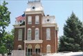 view gallery view galleryNW17.4 km |  Dent County Courthouse - Salem, MO Dent County Courthouse - Salem, MO
in Victorian Style Architecture A courthouse was about 4 blocks north of this site, and was destroyed during the Civil War. This courthouse for Dent County was built 1870. posted by: YoSam. location: Missouri date approved: 02/29/2020 last visited: never |
 view gallery view galleryNW17.4 km |  Dent County Courthouse ~ Salem, MO Dent County Courthouse ~ Salem, MO
in Courthouses a courthouse was about 4 blocks north of this site, and was destroyed during the Civil War. This courthouse for Dent County was built 1870. posted by: YoSam. location: Missouri date approved: 03/07/2009 last visited: 08/11/2012 |
 view gallery view galleryNW17.4 km |  Dent County, Missouri Dent County, Missouri
in People-Named Places The White River trail had been used by Indians in Dent County. posted by: YoSam. location: Mississippi date approved: 03/06/2020 last visited: never |
 view gallery view galleryNW17.7 km |  Salem, Dent County, Missouri Salem, Dent County, Missouri
in Human Migration Monuments Miners, farmers, railroaders and Civil War Battle....many springs brought lots of people... posted by: YoSam. location: Missouri date approved: 03/05/2020 last visited: never |
 view gallery view galleryNW17.7 km |  Salem, Missouri Salem, Missouri
in Small Town, Big Name Named for Salem, North Carolina...today part of two town merged together and known as "Winston-Salem, NC" posted by: YoSam. location: Missouri date approved: 03/02/2020 last visited: never |
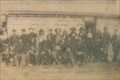
 view gallery view galleryNW17.7 km |  FIRST - Pioneers, School - Salem, MO FIRST - Pioneers, School - Salem, MO
in First of its Kind Miners, farmers, railroaders and Civil War Battle....many springs brought lots of people... posted by: YoSam. location: Missouri date approved: 03/01/2020 last visited: never |
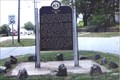 view gallery view galleryNW17.7 km |  Salem, Missouri Salem, Missouri
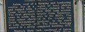
in Missouri Historical Markers History of the town, rivers, mines, and settlers in this Plateau county. posted by: YoSam. location: Missouri date approved: 03/06/2008 last visited: 08/11/2012 |
 view gallery view gallery SW17.9 km SW17.9 km
| ") Devil's Well (AKA) Cave Spring, Shannon Co., Missouri Devil's Well (AKA) Cave Spring, Shannon Co., Missouri
in Cave Entrances (Natural) Devil's Well (AKA) Cave Spring, Shannon Co., Missouri. Both Devil's Well and Wallace Well are karst windows, the first a sinkhole opening onto an underground lake larger than a football field, and the second, a cave containing access to another conduit which flows to the spring. posted by: Headstone Hunter 1 location: Missouri date approved: 04/17/2011 last visited: 02/17/2013 |
 S19.3 km | Cave Spring Cave in Cave Entrances (Natural) This Cave is located within the Ozark National Scenic Riverways National Park along the Current River. This cave is visible and accessable from the Current River. posted by: Kat&Rob location: Missouri date approved: 01/22/2007 last visited: 02/17/2013 |
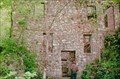 view gallery view gallerySW20.3 km |  Welch Spring Hospital Welch Spring Hospital
in Ghost Towns This was never a town but was an abandonded Hospital that the founder hoped would turn into a thriving location. posted by: Kat&Rob location: Missouri date approved: 01/22/2007 last visited: never |
 view gallery view gallerySW20.3 km | Welch Cave & Hospital in Cave Entrances (Natural) This Cave is surounded by the ruins of a Hospital. It is located on the Current River in the Ozark National Scenic Riverways. Be sure to read the Long Description and look at the web link to find out more. posted by: Kat&Rob location: Missouri date approved: 01/22/2007 last visited: never |
 view gallery view gallerySW20.4 km | Nichols Farm District in U.S. National Register of Historic Places Historic Cabin and barns depicting the early 1900's farmsteads in the Ozarks of Missouri posted by: MoOzarksRegionalExplorers location: Missouri date approved: 04/12/2007 last visited: never |
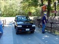 view gallery view gallerySW20.6 km |  Akers Ferry Current River Shannon Co., Missouri Akers Ferry Current River Shannon Co., Missouri
in Ferries and Ferry Landings Akers Ferry Shannon County, Missouri. This is the last ferry operating in the Ozark National Scenic Riverways. posted by: Headstone Hunter 1 location: Missouri date approved: 09/18/2007 last visited: 09/18/2007 |
S20.9 km | Rock House Cave / Natural Bridge in Cave Entrances (Natural) While this structure is know as more of a cave it has the characteristics of a Natural Bridge. Consiting of a Large Room with two distinct openings this cave sits elevated on a bluff overlooking the Current River in Missouri. posted by: Kat&Rob location: Missouri date approved: 01/22/2007 last visited: never |
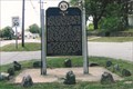
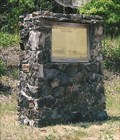 view gallery view galleryNW20.9 km |  Historical Marker Cairn - Trail of Tears - Salem, MO Historical Marker Cairn - Trail of Tears - Salem, MO
in Cairns Andrew Jackson decided he was bigger than the Supreme Court, or the Constitution... posted by: YoSam. location: Missouri date approved: 02/29/2020 last visited: never |
 view gallery view galleryNW20.9 km |  White River Trace - Trail of Tears - Salem, MO White River Trace - Trail of Tears - Salem, MO
in Civil Rights Memorials Andrew Jackson decided he was bigger than the Supreme Court, or the Constitution... posted by: YoSam. location: Missouri date approved: 02/29/2020 last visited: never |
 view gallery view galleryNW20.9 km | White River Trace - Trail of Tears - Salem, MO in Missouri Historical Markers Cherokees driven by Andy Jackson from their lands, even though the Supreme Court said they had the right to stay. posted by: YoSam. location: Missouri date approved: 04/06/2008 last visited: 06/23/2012 |
|