 view gallery view gallery SE19.2 km SE19.2 km
|   Pritchett Hotel Lions - Pritchett, CO Pritchett Hotel Lions - Pritchett, CO
in Lion Statues Two lion statues greet visitors to the Pritchett Hotel in rural southeast Colorado. posted by:  hykesj hykesj location: Colorado date approved: 12/10/2023 last visited: never |
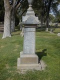
 view gallery view gallerySE34.1 km |  Springfield Cemetery - Springfield, CO Springfield Cemetery - Springfield, CO
in Worldwide Cemeteries Springfield Cemetery is about a mile southwest of Springfield, Colorado. posted by: The Snowdog location: Colorado date approved: 09/13/2023 last visited: never |
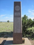
 view gallery view gallerySE34.3 km |  Springfield Cemetery Veterans Memorial - Springfield, CO Springfield Cemetery Veterans Memorial - Springfield, CO
in Non-Specific Veteran Memorials This modest veterans memorial is in Springfield Cemetery - southwest of Springfield, Colorado. posted by: The Snowdog location: Colorado date approved: 09/19/2023 last visited: never |
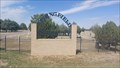
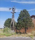 view gallery view gallery E36 km E36 km
|  Commanche Ranger Station Windmill - Springfield, CO Commanche Ranger Station Windmill - Springfield, CO
in Windmills This wooden windmill is just outside the Commanche Ranger Station - in Springfield, Colorado. posted by: The Snowdog location: Colorado date approved: 09/12/2023 last visited: never |
 view gallery view galleryE36 km |  Smokey Bear - Springfield, CO Smokey Bear - Springfield, CO
in Smokey Bear Sign Sightings Smokey Bear stands watch over this Fire Danger Sign - in Springfield, Colorado. posted by: The Snowdog location: Colorado date approved: 09/13/2023 last visited: never |
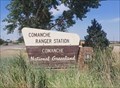 view gallery view galleryE36 km |  Commanche Ranger Station - Springfield, CO Commanche Ranger Station - Springfield, CO
in Ranger Stations The Commanche Ranger Station is on the east side of Highway 385, on the south side of Springfield, Colorado. posted by: The Snowdog location: Colorado date approved: 09/15/2023 last visited: never |
 view gallery view galleryE36.2 km |  Springfield Truck Stop - Springfield, CO Springfield Truck Stop - Springfield, CO
in Truck Stops Springfield Truck Stop is at the northeast corner of Highways 385 and 160 - south of Springfield, Colorado. posted by: The Snowdog location: Colorado date approved: 09/12/2023 last visited: never |
 view gallery view gallery NE39.6 km NE39.6 km
| Giants In The Land in Windmills This cache gives you the opportunity to look simultaneously at an old fashioned water pumping windmill along side a new electricity generating windmill. posted by: JeremyConrad location: Colorado date approved: 07/22/2007 last visited: 10/18/2009 |
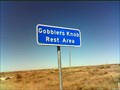 view gallery view galleryNE44.9 km |  Gobblers Knob Rest Area - Prowers County, Colorado, Gobblers Knob Rest Area - Prowers County, Colorado,
in Highway Rest Areas The Gobblers Knob Rest Area is located on the west side of Hwy 287 / 385, about 23 miles south of Lamar....the county seat for Prowers County. posted by:  condor1 condor1 location: Colorado date approved: 12/07/2009 last visited: 05/10/2021 |
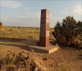
 view gallery view gallery S55.7 km S55.7 km
|  Old Colorado - New Mexico - Oklahoma Tri-Point Stone Old Colorado - New Mexico - Oklahoma Tri-Point Stone
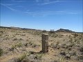
in U.S. Historic Survey Stones and Monuments Survey stone place in 1881 marking the southeast corner of Colorado thus the tri-point of three states located .2 miles north of the current tri-point stone. posted by:  BruceS BruceS location: Colorado date approved: 04/12/2012 last visited: 07/05/2018 |
 view gallery view galleryS55.7 km |  BOUNDARY MI COR OLD CO NM OK BOUNDARY MI COR OLD CO NM OK
in U.S. Benchmarks Survey stone place in 1881 marking the southeast corner of Colorado thus the tri-point of three states located .2 miles north of the current tri-point posted by: BruceS location: Colorado date approved: 04/11/2012 last visited: 07/05/2018 |
 view gallery view galleryS56 km | BOUNDARY MI COR CO NM OK RESET in U.S. Benchmarks Tri-point monument marking the border of Colorado, New Mexico and Oklahoma. posted by: BruceS location: Colorado date approved: 04/13/2012 last visited: 07/05/2018 |
 view gallery view galleryS56 km | Colorado - New Mexico - Oklahoma Tri-Point in U.S. Historic Survey Stones and Monuments Tri-point monument marking the border of Colorado, New Mexico and Oklahoma. posted by: BruceS location: Colorado date approved: 04/13/2012 last visited: 07/05/2018 |
 view gallery view galleryS56 km |  Colorado - New Mexico - Oklahoma Tri-Point Colorado - New Mexico - Oklahoma Tri-Point
in Tripoints and Multipoints Tri-point for Colorado - New Mexico - Oklahoma located north northwest of Kenton, Oklahoma. posted by: BruceS location: Colorado date approved: 03/31/2012 last visited: 07/05/2018 |
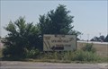
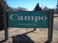 view gallery view gallerySE57.8 km |  Campo, CO Campo, CO
in Welcome Signs Campo, Colorado is proclaimed as "EMERALD OF THE PLAINS" posted by: condor1 location: Colorado date approved: 02/13/2012 last visited: 09/10/2023 |
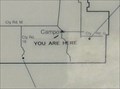 view gallery view gallerySE57.8 km |  "You Are Here" - in Campo, CO "You Are Here" - in Campo, CO
in 'You Are Here' Maps Wow, You Are Here in Campo Colorado when you visit this waymark. posted by: condor1 location: Colorado date approved: 06/04/2012 last visited: 09/10/2023 |
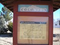 view gallery view gallerySE57.9 km |  Explore Southeast Colorado - Campo, CO Explore Southeast Colorado - Campo, CO
in Colorado Historical Markers Found in the small Colorado town of Campo, this 3 Panel Historical Marker has seen better days. posted by: condor1 location: Colorado date approved: 02/05/2012 last visited: 09/10/2023 |
 view gallery view gallerySE57.9 km |  First Homesteaders of BACA County - Campo, CO First Homesteaders of BACA County - Campo, CO
in First of its Kind This pair of Dedication Sculptures sit on the South end of Campo, CO along Main St. (On the west side of the road) They are next to the "Welcome To Campo" sign posted by: condor1 location: Colorado date approved: 07/04/2010 last visited: 09/10/2023 |
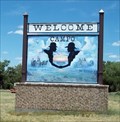 view gallery view gallerySE57.9 km |  Campo (center of Town) Welcome Sign - Campo, CO Campo (center of Town) Welcome Sign - Campo, CO
in Artistic Welcome Signs Campo, Colorado is proclaimed as "EMERALD OF THE PLAINS" posted by: condor1 location: Colorado date approved: 06/12/2013 last visited: 09/10/2023 |
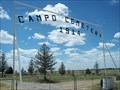 view gallery view gallerySE58.7 km | Campo Cemetery - Campo, CO in Worldwide Cemeteries The Campo Cemetery is located about 1.25 miles east of Campo, on the south side of Co Rd J. posted by: condor1 location: Colorado date approved: 07/06/2010 last visited: 09/10/2023 |
 view gallery view galleryS60.4 km |  Dinosaur Tracks - Black Mesa, OK Dinosaur Tracks - Black Mesa, OK
in Petrosomatoglyphs These dinosaur tracks have been preserved in a sandstone strata next to Carrizo Creek - near Black Mesa, Oklahoma. posted by: The Snowdog location: Oklahoma date approved: 06/25/2021 last visited: never |
 view gallery view galleryS60.4 km |  Dinosaur Tracks - Black Mesa, OK Dinosaur Tracks - Black Mesa, OK
in Official Local Tourism Attractions These dinosaur tracks have been preserved in a sandstone strata next to Carrizo Creek - near Black Mesa, Oklahoma. posted by: The Snowdog location: Oklahoma date approved: 06/26/2021 last visited: never |
 view gallery view gallery N62.9 km N62.9 km
|  William Bent - Las Animas Cemetery - Las Animas, Co. William Bent - Las Animas Cemetery - Las Animas, Co.
in Grave of a Famous Person William Bent was a major trader on the Santa Fe Trail. He, his brother Charles, and Ceran St. Vrain created two forts in Colorado along the Arkansas River to facilitate fur trade with the Native Americans. posted by: iconions location: Colorado date approved: 10/28/2012 last visited: never |
 view gallery view galleryS63.6 km |  Oklahoma High Point (Black Mesa) Oklahoma High Point (Black Mesa)
in Geographic High Points Though it is not the highest point of the mesa itself, this spot on Black Mesa is the highest point in the State of Oklahoma. posted by: madmallard location: Oklahoma date approved: 03/24/2011 last visited: 07/05/2018 |
 view gallery view galleryS63.6 km |  Black Mesa - Kenton, OK Black Mesa - Kenton, OK
in American Guide Series Black Mesa, the highest point in the state, is described in the WPA Guide to 1930s Oklahoma - near Kenton, Oklahoma. posted by: The Snowdog location: Oklahoma date approved: 11/23/2021 last visited: never |
|