 view gallery view gallery S0 km S0 km
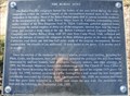
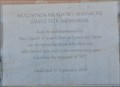
|   The Mountain Meadows Massacre The Mountain Meadows Massacre
in Utah Historical Markers Over 150 years later, the Mountain Meadows Massacre is still raising the hackles of Mormons and Gentiles (non-Mormons) alike. posted by:  brwhiz brwhiz location: Utah date approved: 04/22/2011 last visited: never |
 view gallery view gallery W0 km W0 km
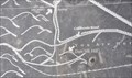
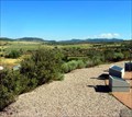
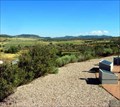
|  Dan Sill Hill Dan Sill Hill
in 'You Are Here' Maps You Are Here on the side of Dan Sill Hill above the scene of the Mountain Meadows Massacre west of Utah Highway 18 between Central and Enterprise, Utah. posted by: brwhiz location: Utah date approved: 11/15/2012 last visited: never |
 view gallery view galleryW0 km |  First Trip on Old Spanish Trail from Santa Fe to Los Angeles First Trip on Old Spanish Trail from Santa Fe to Los Angeles
in First of its Kind Antonio Armijo was the first to complete the circuit from Santa Fe to Los Angeles on the Old Spanish Trail. posted by: brwhiz location: Utah date approved: 11/11/2012 last visited: never |
 view gallery view galleryW0 km | First Wheeled Vehicles Over the California Road in First of its Kind Mormon Battalion members drove the first wheeled vehicles over the improved and realigned Old Spanish Trail that came to be known as the 'California Road'. posted by: brwhiz location: Utah date approved: 11/11/2012 last visited: never |
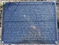
 view gallery view galleryW0 km |  The Old Spanish Trail and The California Road The Old Spanish Trail and The California Road
in Wagon Roads and Trails Mormon Battalion members improved and realigned the Old Spanish Trail so that it was usable by wagons. This new route became known as the 'California Road'. posted by: brwhiz location: Utah date approved: 11/11/2012 last visited: never |
 view gallery view galleryW0 km | 1990 Mountain Meadows Memorial in Utah Historical Markers Over 150 years later, the Mountain Meadows Massacre is still raising the hackles of Mormons and Gentiles (non-Mormons) alike. posted by: brwhiz location: Utah date approved: 11/12/2012 last visited: never |
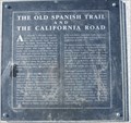 view gallery view galleryW0 km | The Old Spanish Trail and The California Road in Utah Historical Markers This Historical Marker is mounted on a dressed-stone monument on Dan Sill Hill above the site of the Mountain Meadows Massacre of 1857, west of Utah Highway 18 north of Central, Utah. posted by: brwhiz location: Utah date approved: 11/11/2012 last visited: never |
 view gallery view gallery SW0 km SW0 km
| The Burial Sites in Utah Historical Markers This Historical Marker is mounted on a steel post on Dan Sill Hill above the site of the Mountain Meadows Massacre of 1857, west of Utah Highway 18 north of Central, Utah. posted by: brwhiz location: Utah date approved: 11/11/2012 last visited: never |
 view gallery view galleryW1 km |  Mountain Meadows Massacre Site, Utah, Washington County Mountain Meadows Massacre Site, Utah, Washington County
in U.S. National Register of Historic Places Mountain Meadows Massacre Site is a National Historic Landmark as of 6/23/2011 posted by: Rose Red location: Utah date approved: 07/29/2011 last visited: 02/12/2011 |
 view gallery view galleryW1 km |  Mountain Meadows Massacre, Utah Mountain Meadows Massacre, Utah
in Infamous Crime Scenes The Mountain Meadows Massacre involved a mass slaughter of the Fancher-Baker emigrant wagon train at Mountain Meadows in the Utah Territory by the local Mormon militia in September 1857. posted by: Rose Red location: Utah date approved: 06/29/2008 last visited: 02/12/2011 |
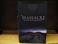 view gallery view galleryW1 km |  Massacre at Mountain Meadows: An American Tragedy - Utah Massacre at Mountain Meadows: An American Tragedy - Utah
in There's a Book About It On September 11, 1857, a band of Mormon militia, under a flag of truce, lured a party of unarmed emigrants from their fortified encampment and, with their Paiute allies, killed them. More than 120 men, women, and children perished in the slaughter. posted by: Rose Red location: Utah date approved: 01/29/2009 last visited: never |
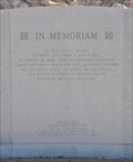
 view gallery view galleryW1.1 km | Mountain Meadows Massacre Grave Site Memorial in Utah Historical Markers This Historical Marker is mounted on the rock cairn of the Mountain Meadows Massacre burial site, west of Utah Highway 18 north of Central, Utah. posted by: brwhiz location: Utah date approved: 11/11/2012 last visited: never |
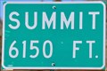 view gallery view gallery N6 km N6 km
|  Mountain Meadows Summit ~ Elevation 6150 Mountain Meadows Summit ~ Elevation 6150
in Elevation Signs This summit on Utah Highway 18 is just a few miles north of the road to the Mountain Meadows Massacre Site. posted by: brwhiz location: Utah date approved: 06/12/2011 last visited: 01/30/2012 |
 view gallery view galleryS6.8 km | Central, Utah Map in 'You Are Here' Maps You Are Here at the southwestern corner of the small rural town of Central, Utah just east of the junction of Pine Valley Highway and Utah Highway 18. posted by: brwhiz location: Utah date approved: 11/15/2012 last visited: never |
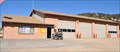 view gallery view galleryS6.8 km |  Brookside/Central Fire Department Brookside/Central Fire Department
in Firehouses This Firehouse is located at 155 E Center Street (Pine Valley Highway East) in Central, Utah. posted by: brwhiz location: Utah date approved: 04/16/2013 last visited: never |
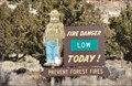 view gallery view galleryS6.8 km |  Brookside-Central Fire Station Smokey Bear Brookside-Central Fire Station Smokey Bear
in Smokey Bear Sign Sightings Smokey is at the Fire Station in Central. What better place for Smokey to make you aware of the fire danger? Today it is low. posted by: brwhiz location: Utah date approved: 04/18/2011 last visited: never |
 view gallery view gallery SE9.2 km SE9.2 km
|  Cliffrose Cliffrose
in Flora and Fauna Information Signs This Flora and Fauna Information Sign is on the south side of Pine Valley Highway four miles east of Central, Utah. posted by: brwhiz location: Utah date approved: 11/16/2012 last visited: never |
 view gallery view gallery NE12.2 km NE12.2 km
|  Pinto ~ 204 Pinto ~ 204
in D.U.P. Historic Markers The town of Pinto was named after the pinto-like coloring of the surrounding rock formations. posted by: brwhiz location: Utah date approved: 03/29/2012 last visited: never |
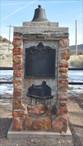 view gallery view galleryNE12.2 km |  Pinto Marker Bell - Pinto, Iron County, Utah Pinto Marker Bell - Pinto, Iron County, Utah
in Bells The bell on top of the Pinto historical marker monument is probably from the original LDS Church in Pinto, Utah. posted by: brwhiz location: Utah date approved: 03/13/2012 last visited: never |
 view gallery view galleryNE12.2 km | Pinto in Utah Historical Markers The town of Pinto was named after the pinto-like coloring of the surrounding rock formations. posted by: brwhiz location: Utah date approved: 03/14/2012 last visited: never |
 view gallery view galleryNE12.2 km | First LDS Bishop of Pinto, Utah in First of its Kind The first LDS Bishop of Pinto was Richard S. Robinson. posted by: brwhiz location: Utah date approved: 03/13/2012 last visited: never |
 view gallery view gallery NW12.4 km NW12.4 km
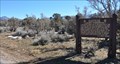
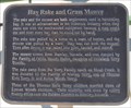
| Hay Rake and Grass Mower in Utah Historical Markers This Historical Marker is mounted on a steel post in next to the hay harvesting equipment in the Enterprise Heritage Park on the east edge of Enterprise, Utah. posted by: brwhiz location: Utah date approved: 04/15/2013 last visited: never |
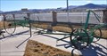 view gallery view galleryNW12.4 km |  Hay Rake and Sickle Mower Hay Rake and Sickle Mower
in Old Agricultural Equipment These pieces of Old Agricultural Equipment is located with a display of similar equipment at the Enterprise Heritage Park on the east edge of Enterprise, Utah. posted by: brwhiz location: Utah date approved: 04/17/2013 last visited: never |
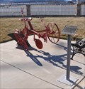 view gallery view galleryNW12.4 km | Single-Bottom One-Way Plow in Old Agricultural Equipment This piece of Old Agricultural Equipment is located with a display of similar equipment at the Enterprise Heritage Park on the east edge of Enterprise, Utah. posted by: brwhiz location: Utah date approved: 04/17/2013 last visited: never |
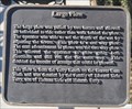 view gallery view galleryNW12.4 km | Large Plow in Utah Historical Markers This Historical Marker is mounted on a steel post in front of the large single-bottom plow in the Enterprise Heritage Park on the east edge of Enterprise, Utah. posted by: brwhiz location: Utah date approved: 04/15/2013 last visited: never |
|