 view gallery view gallery SE2.3 km SE2.3 km
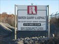
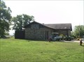
|   Marion Quarry and Asphalt - Marion, KY Marion Quarry and Asphalt - Marion, KY
in Active Quarries Owned and Operated by Rogers Group, which is still privately owned by Ralph Rogers' family. posted by:  kodiak_62 kodiak_62 location: Kentucky date approved: 11/11/2008 last visited: 11/12/2008 |
 view gallery view gallery S4.8 km S4.8 km
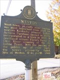
|  Weston ~ Vital Junction Weston ~ Vital Junction
in Kentucky Historical Markers With the passing of the golden age of river trade, the town's prosperity faded posted by: ReedKyCacheFinders location: Kentucky date approved: 10/18/2008 last visited: 01/22/2011 |
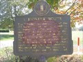 view gallery view galleryS4.8 km | A Pioneer Route in Kentucky Historical Markers Movement of Civil War troops was the last major use of this road. posted by: ReedKyCacheFinders location: Kentucky date approved: 10/18/2008 last visited: 11/10/2008 |
 view gallery view gallery NW5.8 km NW5.8 km
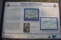
| Weston Bluff Skirmish - Weston - KY in Kentucky Historical Markers Weston Bluff Skirmish in Weston, Kentucky posted by: ReedKyCacheFinders location: Kentucky date approved: 12/06/2020 last visited: 08/24/2010 |
 view gallery view gallery N6.9 km N6.9 km
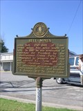
| Bell's Mine - Kentucky in Kentucky Historical Markers Bell's Mine located off of Hwy. 365 South of Sturgis,in Crittenden County, Kentucky. posted by: ReedKyCacheFinders location: Kentucky date approved: 12/06/2020 last visited: 10/16/2010 |
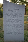 view gallery view galleryN6.9 km | BELLS MINES CHURCH - BELLS MINES CEMETERY CRITTENDEN COUNTY, KENTUCKY in Kentucky Historical Markers BELLS MINES CHURCH - BELLS MINES CEMETERY CRITTENDEN COUNTY, KENTUCKY. posted by: ReedKyCacheFinders location: Kentucky date approved: 12/06/2020 last visited: never |
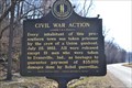 view gallery view galleryN10.9 km | CIVIL WAR ACTION in Kentucky Historical Markers Every Inhabitant of this PRO-Southern town was taken prisoner by the crew of a Union gunboat. posted by: ReedKyCacheFinders location: Kentucky date approved: 03/25/2014 last visited: never |
 view gallery view galleryN11.4 km |  Sturgis KY Post Office - 42459 Sturgis KY Post Office - 42459
in U.S. Post Offices This post office is located at 409 N. Main St. (corner of 4th St. and Main, near US 60) in Sturgis, which is in Union Co. posted by: Team Turtle-Ham location: Kentucky date approved: 06/09/2014 last visited: never |
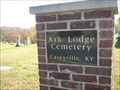 view gallery view galleryN11.4 km |  Ark Lodge Cemetary - Caseyville, KY, USA Ark Lodge Cemetary - Caseyville, KY, USA
in Worldwide Cemeteries Small country cemetary sitting atop a hill near Caseyville along the Ohio River. posted by: kodiak_62 location: Kentucky date approved: 11/05/2008 last visited: 11/05/2008 |
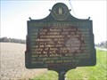
 view gallery view galleryN11.4 km | Bell Mines in Kentucky Historical Markers John Bell member of Congress and Senate posted by: ReedKyCacheFinders location: Kentucky date approved: 10/18/2008 last visited: 02/11/2009 |
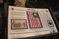
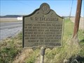
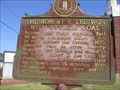 view gallery view galleryN11.4 km | The Robert E. Lee Won with Sturgis Coal in Kentucky Historical Markers The Robert E. Lee Won with Sturgis Coal posted by: ReedKyCacheFinders location: Kentucky date approved: 10/18/2008 last visited: 12/26/2010 |
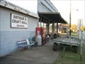 view gallery view galleryN11.6 km |  Sturgis Antique and Craft Mall - Sturgis, KY Sturgis Antique and Craft Mall - Sturgis, KY
in Antique Shops Located in the old pants factory. posted by: kodiak_62 location: Kentucky date approved: 10/27/2008 last visited: 11/10/2008 |
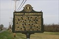
 view gallery view galleryN11.7 km | Forrest Reconnoitered in Kentucky Historical Markers Located along HWY 109, west of Sturgis, KY. posted by: kodiak_62 location: Kentucky date approved: 11/04/2008 last visited: 07/08/2009 |
 view gallery view galleryN11.7 km | US Treasurer in Kentucky Historical Markers Located on HWY 109, west of Sturgis, KY. posted by: kodiak_62 location: Kentucky date approved: 11/05/2008 last visited: 07/08/2009 |
 view gallery view galleryS11.9 km | Forrest Reconnoitered ~Confederate Raids and Invasions and a Federal Retreat, in Kentucky in Kentucky Historical Markers Forrest Reconnoitered ~Confederate Raids and Invasions and a Federal Retreat, in Kentucky Located 1 mi. NE of Marion,Ky. on US 60. posted by: ReedKyCacheFinders location: Kentucky date approved: 04/03/2010 last visited: 06/17/2010 |
 view gallery view gallery W12.1 km W12.1 km
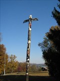
|  Cave in Rock State Park Totem Cave in Rock State Park Totem
in Outside Wooden Display Carvings Located in the front yard of the Lodge at Cave in Rock State Park posted by: kodiak_62 location: Illinois date approved: 11/08/2008 last visited: 11/09/2008 |
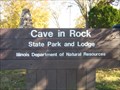 view gallery view galleryW12.1 km |  Cave in Rock State Park - Illinois Cave in Rock State Park - Illinois
in State/Provincial Parks Located near Cave in Rock, Illinois.
State Park has alot to do while you relax and enjoy your stay. posted by: kodiak_62 location: Illinois date approved: 11/05/2008 last visited: 08/07/2006 |
 view gallery view galleryW12.1 km |  Cave in Rock State Park Lodge - Cave in Rock, IL Cave in Rock State Park Lodge - Cave in Rock, IL
in Lodge-Style Accommodations Cave in Rock State Park contains a famous cave along the shore of the Ohio River. This lodge facility features 4 duplex lodges, all with a beautiful view of the Ohio River. posted by:  onfire4jesus onfire4jesus location: Illinois date approved: 08/09/2008 last visited: 11/04/2008 |
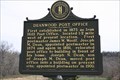 view gallery view gallerySE12.6 km | DEANWOOD POST OFFICE in Kentucky Historical Markers Deanwood Post Office Located in Deanwood, 9 mi. W. of Marion, on KY 120. posted by: ReedKyCacheFinders location: Kentucky date approved: 04/03/2010 last visited: 04/03/2010 |
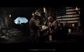 view gallery view galleryW12.6 km |  How the West was Won - Cave in Rock, IL How the West was Won - Cave in Rock, IL
in Movie Locations How the West was Won" was filmed inside Cave in Rock cave for the release in 1962. posted by: kodiak_62 location: Illinois date approved: 11/05/2008 last visited: 08/07/2006 |
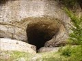
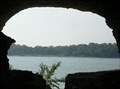
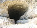 view gallery view galleryW12.6 km | ") Cave in Rock - Illinois Cave in Rock - Illinois
in Cave Entrances (Natural) The "Cave in Rock" cave opening is located along the banks of the Ohio River near Cave in Rock, IL. posted by: kodiak_62 location: Illinois date approved: 11/05/2008 last visited: 08/07/2006 |
 view gallery view galleryW12.6 km |  Cave-in-Rock State Park - Cave In Rock, IL Cave-in-Rock State Park - Cave In Rock, IL
in Wikipedia Entries Cave-In-Rock was an infamous den of river pirates in the early 19th century. It is located in Cave-In-Rock State Park just east of Cave-In-Rock, IL. Was also use in the Cinerama movie "How The West Was Won" posted by: YoSam. location: Illinois date approved: 07/11/2023 last visited: never |
 view gallery view galleryW12.6 km |  Cave-In-Rock - Cave-In-Rock, Illinois Cave-In-Rock - Cave-In-Rock, Illinois
in Roadside Attractions Cave-In-Rock was an infamous den of river pirates in the early 19th century. It is located in Cave-In-Rock State Park just east of Cave-In-Rock, IL. Was also use in the Cinerama movie "How The West Was Won" posted by: YoSam. location: Illinois date approved: 07/11/2023 last visited: never |
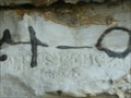 view gallery view galleryW12.6 km |  Cave In Rock Historic Graffiti - Cave In Rock, IL Cave In Rock Historic Graffiti - Cave In Rock, IL
in Graffiti Cave-In-Rock was an infamous den of river pirates in the early 19th century. The cave has numerous examples of graffiti dating back to at least 1854. The cave is located in the Cave In Rock State Park just east of Cave In Rock, IL. posted by: onfire4jesus location: Illinois date approved: 11/23/2008 last visited: 02/18/2017 |
 view gallery view galleryW12.6 km |  Cave-In-Rock - Cave In Rock, IL Cave-In-Rock - Cave In Rock, IL
in U.S. National Register of Historic Places This infamous cave was a den for river pirates in the early 19th century. It is located on the northwest bank of the Ohio River in the Cave-In-Rock State Park in southern Illinois. posted by: onfire4jesus location: Illinois date approved: 11/18/2008 last visited: 08/07/2006 |
|