 view gallery view gallery S8 km S8 km
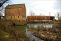
|   Bollinger Mill State Historic Site - Bollinger, MO Bollinger Mill State Historic Site - Bollinger, MO
in State/Provincial Parks Historic wood covered bridge and mill at Bollinger Mill State Historic Site. posted by:  kJfishman kJfishman location: Missouri date approved: 04/04/2016 last visited: 09/24/2011 |
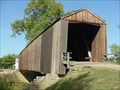 view gallery view galleryS8 km |  Burfordville Covered Bridge Burfordville Covered Bridge
in U.S. National Register of Historic Places Burfordville Covered Bridge is the oldest remaining covered bridge in Missouri. Located in Bollinger Mill State Historic Site. posted by: paulspaper location: Missouri date approved: 10/13/2007 last visited: 09/24/2011 |
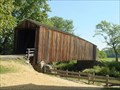 view gallery view galleryS8 km |  Burfordville Covered Bridge - Burfordville, Missouri Burfordville Covered Bridge - Burfordville, Missouri
in Covered Bridges Burfordville Covered Bridge is the oldest remaining covered bridge in Missouri. Located in Bollinger Mill State Historic Site. posted by: paulspaper location: Missouri date approved: 10/12/2007 last visited: 09/24/2011 |
 view gallery view galleryS8 km |  Bollinger Mill State Historic Site - Bollinger MO Bollinger Mill State Historic Site - Bollinger MO
in Civil War Discovery Trail Sites The Mill was burnt down by the Union Army to prevent flour and meal to be sent to the Confederate Army. posted by: kJfishman location: Missouri date approved: 04/09/2016 last visited: 09/24/2011 |
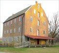
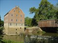 view gallery view galleryS8 km | Burfordville Mill in U.S. National Register of Historic Places Burfordville Mill, known as Bollinger Mill, is a massive four-story stone and brick building where visitors can still observe corn being ground into meal by water power - just as it was done long ago.
posted by: paulspaper location: Missouri date approved: 10/13/2007 last visited: 09/24/2011 |
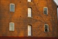 view gallery view galleryS8 km |  Cape County Milling Company - Bollinger Mill Burfordville, Missouri Cape County Milling Company - Bollinger Mill Burfordville, Missouri
in Ghost Signs Cape County Milling Company - Bollinger Mill Burfordville, Missouri posted by: kJfishman location: Missouri date approved: 12/18/2009 last visited: 09/24/2011 |
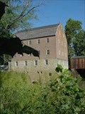 view gallery view galleryS8 km |  Bollinger Mill, Burfordville, Missouri Bollinger Mill, Burfordville, Missouri
in Water Mills Bollinger Mill is a massive four-story stone and brick building where visitors can still observe corn being ground into meal by water power - just as it was done long ago. posted by: paulspaper location: Missouri date approved: 10/14/2007 last visited: 09/27/2011 |
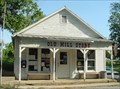 view gallery view galleryS8 km |  Burfordville, Missouri, 63739 Burfordville, Missouri, 63739
in U.S. Post Offices Post office Burfordville, Missouri. Located at 353 State Highway HH, Burfordville, MO, 63739-9998 posted by: paulspaper location: Missouri date approved: 10/11/2007 last visited: 11/22/2009 |
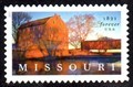 view gallery view galleryS8 km |  Bollinger Mill and Covered Bridge, Burfordville, MO Bollinger Mill and Covered Bridge, Burfordville, MO
in Philatelic Photographs A view of Bollinger Mill State Historic Site graces this 2021 postage stamp commemorating the State of Missouri’s 200th anniversary. posted by: hykesj location: Missouri date approved: 08/29/2021 last visited: never |
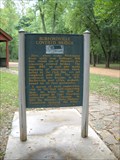 view gallery view galleryS8.2 km |  Burfordville Covered Bridge/Bollinger Mill - Burfordville, Mo. Burfordville Covered Bridge/Bollinger Mill - Burfordville, Mo.
in Missouri Historical Markers This Historical Marker is located within the Bollinger Mill State Park - 113 Bollinger Mill Road in Burfordville. Mo. posted by: iconions location: Missouri date approved: 10/05/2011 last visited: never |
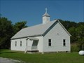 view gallery view galleryS9.3 km |  Gravel Hill United Methodist Church - MO Gravel Hill United Methodist Church - MO
in Country Churches Rural church in Southeast Missouri. posted by: paulspaper location: Missouri date approved: 10/13/2007 last visited: never |
 view gallery view gallery SE10.5 km SE10.5 km
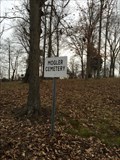
|  Mogler Cemetery - Jackson, MO. Mogler Cemetery - Jackson, MO.
in Worldwide Cemeteries There area 109 graves in this cemetery. posted by: Mesozoic location: Missouri date approved: 06/09/2016 last visited: never |
 view gallery view gallery NW11.6 km NW11.6 km
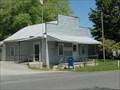
| Sedgewickville, Missouri, 63781 in U.S. Post Offices Post office in the small rural community of Sedgewickville, Missouri. The old building has an old metal roof and a front porch. posted by: paulspaper location: Missouri date approved: 10/13/2007 last visited: never |
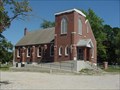 view gallery view galleryNW11.7 km | Sedgewickville Lutheran Church - Sedgewickville, MO in Lutheran Churches Old Lutheran Church in Sedgewickville, Missouri. posted by: paulspaper location: Missouri date approved: 04/25/2008 last visited: never |
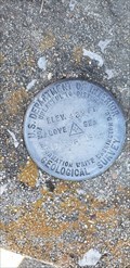 view gallery view gallerySE12.4 km |  17 FDR 1966 - Byrd Township, MO 17 FDR 1966 - Byrd Township, MO
in U.S. Benchmarks Geological Survey mark at the Immanuel Lutheran Church in Byrd Township posted by: HiddenCrazy location: Missouri date approved: 04/28/2021 last visited: 02/24/2021 |
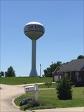 view gallery view gallerySE12.4 km |  West of town - water tower - Jackson, MO. West of town - water tower - Jackson, MO.
in Water Towers Newer water tower in the new subdivision on the west side of Jackson, MO. posted by: Mesozoic location: Missouri date approved: 06/10/2016 last visited: never |
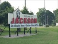 view gallery view gallerySE13.5 km |  Jackson Missouri - west end of town Jackson Missouri - west end of town
in Welcome Signs Classic sign that points to the high points of this quiet town posted by: Mesozoic location: Missouri date approved: 06/18/2016 last visited: never |
 view gallery view gallery E13.7 km E13.7 km
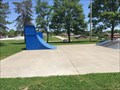
|  Jackson - Skate park - Jackson, Missouri, United States Jackson - Skate park - Jackson, Missouri, United States
in Skateparks City of Jackson's skate park posted by: Mesozoic location: Missouri date approved: 06/13/2016 last visited: never |
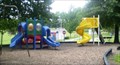
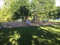 view gallery view galleryE13.8 km |  Rotary lake view playground Rotary lake view playground
in Public Playgrounds Older wooden and medal playground posted by: Mesozoic location: Missouri date approved: 06/08/2016 last visited: never |
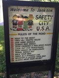 view gallery view gallerySE14 km |  Safety City USA - Jackson, Missouri, United States Safety City USA - Jackson, Missouri, United States
in Traffic Parks Safety City USA is located in Jackson Missouri posted by: Mesozoic location: Missouri date approved: 06/13/2016 last visited: never |
 view gallery view gallerySE14 km | Safety City Playground in Public Playgrounds Playground area contains swings, slides,and climbing gym. posted by: Mesozoic location: Missouri date approved: 06/06/2016 last visited: never |
 view gallery view gallerySE14 km | Russell Heights Cemetery - Jackson, MO. in Worldwide Cemeteries By far the largest cemetery in town with well over 6,000 graves. posted by: Mesozoic location: Missouri date approved: 06/09/2016 last visited: never |
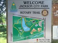 view gallery view gallerySE14 km |  Jackson City Park - You are here Jackson City Park - You are here
in 'You Are Here' Maps City park map, yeah this city park is that big posted by: Mesozoic location: Missouri date approved: 06/09/2016 last visited: never |
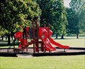 view gallery view gallerySE14 km | Parkview street playground in Public Playgrounds Mostly red playground with slides and mini walking bridge. posted by: Mesozoic location: Missouri date approved: 06/06/2016 last visited: never |
 view gallery view galleryE14.3 km | North Water Tower - Jackson, MO. in Water Towers A small globe type of water tower with lots of support beams. posted by: Mesozoic location: Missouri date approved: 06/10/2016 last visited: never |
|