 view gallery view gallery NE4.2 km NE4.2 km
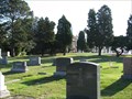
|   St. Joseph Catholic Cemetery - Elizabethtown, Illinois St. Joseph Catholic Cemetery - Elizabethtown, Illinois
in Worldwide Cemeteries Rural cemetery adjacent to St. Joseph Catholic Church near Elizabethtown, Illinois. posted by:  BruceS BruceS location: Illinois date approved: 05/26/2009 last visited: never |
 view gallery view galleryNE4.2 km |  St. Joseph Catholic Church and Cemetery - Elizabethtown, Illinois St. Joseph Catholic Church and Cemetery - Elizabethtown, Illinois
in Churchyard Cemeteries Rural Catholic Church and cemetery near Elizabethtown, Illinois. posted by: BruceS location: Illinois date approved: 05/24/2009 last visited: never |
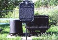
 view gallery view galleryNE4.2 km |  St. Joseph Catholic Church Cemetery Cross - Elizabethtown, Illinois St. Joseph Catholic Church Cemetery Cross - Elizabethtown, Illinois
in Churchyard Crosses Cross at the entrance to the cemetery located adjacent to the St. Joseph Catholic Church in a rural area near Elizabethtown, Illinois.
N37° 27.728 W88° 22.882 posted by: BruceS location: Illinois date approved: 05/23/2009 last visited: never |
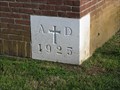 view gallery view galleryNE4.2 km |  1925 - St. Joseph Catholic Church - Elizabethtown, Illinois 1925 - St. Joseph Catholic Church - Elizabethtown, Illinois
in Dated Buildings and Cornerstones Rural Catholic Church near Elizabethtown, Illinois. posted by: BruceS location: Illinois date approved: 05/24/2009 last visited: never |
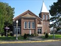 view gallery view galleryNE4.2 km |  St. Joseph Catholic Church - Elizabethtown, Illinois St. Joseph Catholic Church - Elizabethtown, Illinois
in Roman Catholic Churches Rural Catholic Church near Elizabethtown, Illinois. posted by: BruceS location: Illinois date approved: 05/24/2009 last visited: never |
 view gallery view galleryNE4.2 km | St. Joseph Catholic Church - Elizabethtown, Illinois in Country Churches Rural Catholic Church near Elizabethtown, Illinois. posted by: BruceS location: Illinois date approved: 05/26/2009 last visited: never |
 view gallery view gallery E5.3 km E5.3 km
|  Fluorite Mining Fluorite Mining
in Illinois Historical Markers Mining the mineral in Hardin County. posted by:  YoSam. YoSam. location: Illinois date approved: 03/31/2008 last visited: 11/13/2008 |
 view gallery view galleryE5.3 km |  Fluorite Mining Car - Rosiclare, IL Fluorite Mining Car - Rosiclare, IL
in Static Train Cars Fluorite mining has closed down in this area, and now we only get fluorite from China. posted by: YoSam. location: Illinois date approved: 05/07/2015 last visited: never |
 view gallery view gallery S7.6 km S7.6 km
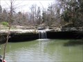
|  Mandy Falls / Marion, Kentucky Mandy Falls / Marion, Kentucky
in Waterfalls Mandy Falls is alongside road 133 near the Mantle Rock area in Marion Kentucky. posted by: ReedKyCacheFinders location: Kentucky date approved: 05/04/2009 last visited: 04/02/2011 |
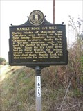 view gallery view galleryS7.9 km |  Mantle Rock (1/2 mile) Mantle Rock (1/2 mile)
in Kentucky Historical Markers Mantle Rock was also campsite for ancient indians. posted by: ReedKyCacheFinders location: Kentucky date approved: 10/18/2008 last visited: 04/02/2011 |
 view gallery view galleryS8.2 km |  Mantle Rock Trail "You Are Here" - Joy, Kentucky Mantle Rock Trail "You Are Here" - Joy, Kentucky
in 'You Are Here' Maps A "You Are Here" sign located at the Mantle Rock Nature Preserve trailhead. posted by: trailhound1 location: Kentucky date approved: 07/13/2011 last visited: 07/08/2011 |
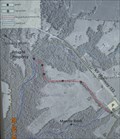
 view gallery view galleryS8.2 km |  Mantle Rock Trail Mantle Rock Trail
in Hiking and walking trailheads Mantle Rock Nature Preserve located two miles north of Joy, Kentucky on Kentcky Highway 133. posted by: trailhound1 location: Kentucky date approved: 07/08/2011 last visited: 07/08/2011 |
 view gallery view gallery SW8.2 km SW8.2 km
|  They Passed This Way - rural Livingston County, Kentucky They Passed This Way - rural Livingston County, Kentucky
in Trail of Tears This National Park Service / Trail of Tears Association marker is at the site of the former Berry's Ferry - a major crossing point of the Ohio River before the Civil War. Located at the end of Hwy 133 in rural Livingston County, Kentucky. posted by: iconions location: Kentucky date approved: 11/17/2020 last visited: never |
 view gallery view gallerySW8.2 km | They Passed This Way - rural Livingston County, Kentucky in Kentucky Historical Markers This National Park Service / Trail of Tears Association marker is at the site of the former Berry's Ferry - a major crossing point of the Ohio River before the Civil War. Located at the end of Hwy 133 in rural Livingston County, Kentucky. posted by: iconions location: Kentucky date approved: 11/21/2020 last visited: 11/22/2020 |
 view gallery view gallerySW8.2 km | Imagine the Scene - rural Livingston County, Kentucky in Kentucky Historical Markers This National Park Service / Trail of Tears Association marker is at the site of the former Berry's Ferry - a major crossing point of the Ohio River before the Civil War. Located at the end of Hwy 133 in rural Livingston County, Kentucky. posted by: iconions location: Kentucky date approved: 11/21/2020 last visited: 11/22/2020 |
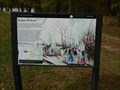 view gallery view gallerySW8.2 km | Imagine the Scene - rural Livingston County, Kentucky in Trail of Tears This National Park Service / Trail of Tears Association marker is at the site of the former Berry's Ferry - a major crossing point of the Ohio River before the Civil War. Located at the end of Hwy 133 in rural Livingston County, Kentucky. posted by: iconions location: Kentucky date approved: 11/17/2020 last visited: never |
 view gallery view gallerySW8.2 km | 'You Are Here' - Berry's Ferry - rural Livingston County, Kentucky in 'You Are Here' Maps This National Park Service / Trail of Tears Association marker is at the site of the former Berry's Ferry - a major crossing point of the Ohio River before the Civil War. Located at the end of Hwy 133 in rural Livingston County, Kentucky. posted by: iconions location: Kentucky date approved: 11/16/2020 last visited: never |
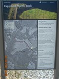
 view gallery view galleryS8.4 km |  Mantle Rock Archeological District - near Joy, Kentucky Mantle Rock Archeological District - near Joy, Kentucky
in U.S. National Register of Historic Places This 215 acre property is located off Hwy 133 near Joy, Kentucky, in rural Livingston County. posted by: iconions location: Kentucky date approved: 11/13/2020 last visited: never |
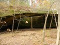
 view gallery view galleryS8.4 km |  Mantle Rock / Livingston County Kentucky Mantle Rock / Livingston County Kentucky
in Natural Arches Mantle Rock Nature Preserve is a 30-foot high natural sandstone bridge spanning 188 feet. posted by: ReedKyCacheFinders location: Kentucky date approved: 09/12/2011 last visited: 11/05/2020 |
 view gallery view galleryS8.4 km |  Mantle Rock Archeological District - near Joy, Kentucky Mantle Rock Archeological District - near Joy, Kentucky
in Wikipedia Entries This 215 acre property is located off Hwy 133 near Joy, Kentucky, in rural Livingston County. posted by: iconions location: Kentucky date approved: 11/12/2020 last visited: never |
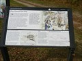
 view gallery view galleryS8.5 km | The Real Story of Mantle Rock - rural Livingston County, Kentucky in Kentucky Historical Markers This marker, sponsored by the National Park Service and the Nature Conservancy, is located outside the entrance of Mantle Rock Arch. This 215 acre property is located off Hwy 133 near Joy, Kentucky, in rural Livingston County. posted by: iconions location: Kentucky date approved: 11/13/2020 last visited: never |
 view gallery view galleryS8.5 km | The Real Story of Mantle Rock - rural Livingston County, Kentucky in Trail of Tears This marker, sponsored by the National Park Service and the Nature Conservancy, is located outside the entrance of Mantle Rock Arch. This 215 acre property is located off Hwy 133 near Joy, Kentucky, in rural Livingston County. posted by: iconions location: Kentucky date approved: 11/17/2020 last visited: never |
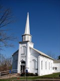 view gallery view galleryE9 km |  OLDEST - Baptist Church In Illinois With Continuous Services - Elizabethtown, Illinois OLDEST - Baptist Church In Illinois With Continuous Services - Elizabethtown, Illinois
in Superlatives The First Baptist Church of Elizabethtown is oldest Baptist Church with continuous services in Illinois. posted by: BruceS location: Illinois date approved: 05/24/2009 last visited: never |
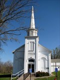 view gallery view galleryE9 km | First Baptist Church - Elizabethtown, Illinois in This Old Church Historic Baptist Church in Elizabethtown, Illinois. posted by: BruceS location: Illinois date approved: 05/24/2009 last visited: never |
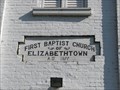 view gallery view galleryE9 km | 1877 - First Baptist Church - Elizabethtown, Illinois in Dated Buildings and Cornerstones Historic Baptist Church in Elizabethtown, Illinois. posted by: BruceS location: Illinois date approved: 05/25/2009 last visited: never |
|