 view gallery view gallery SE2.3 km SE2.3 km
|   Zion National Park - Lava Point Zion National Park - Lava Point
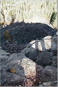
in National Parks of the World These coordinates take you to a basalt flow within Zion National Park. The dirt road from Kolob Road to Lava Point is an easy drive for all but lowered vehicles. However, it is closed during the winter. posted by:  TerryDad2 TerryDad2 location: Utah date approved: 08/24/2006 last visited: 04/30/2007 |
 view gallery view gallery NW14 km NW14 km
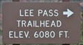
|  Lee Pass Trailhead (South End) ~ Elevation 6080 feet Lee Pass Trailhead (South End) ~ Elevation 6080 feet
in Elevation Signs This Elevation Sign is at the south end of the parking area for the Lee Pass Trailhead in the Kolob Canyons section of Zion National Park. posted by: brwhiz location: Utah date approved: 09/12/2013 last visited: never |
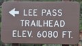 view gallery view galleryNW14.2 km | Lee Pass Trailhead (North End) ~ Elevation 6080 feet in Elevation Signs This Elevation Sign is at the north end of the parking area for the Lee Pass Trailhead in the Kolob Canyons section of Zion National Park. posted by: brwhiz location: Utah date approved: 09/12/2013 last visited: never |
 view gallery view gallery W14.2 km W14.2 km
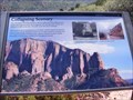
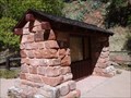
|  Collapsing Scenery-Kolob Canyons-Zion National Park - New Harmony UT Collapsing Scenery-Kolob Canyons-Zion National Park - New Harmony UT
in Utah Historical Markers Marker is located at the Kolob Canyons Viewpoint in New Harmony, Utah, in Washington County 84757. posted by:  Don.Morfe Don.Morfe location: Utah date approved: 11/17/2023 last visited: 11/17/2023 |
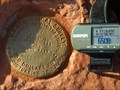
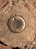 view gallery view galleryW14.2 km |  Radius Point 45 FT - Washington County, UT Radius Point 45 FT - Washington County, UT
in U.S. Benchmarks A disc in concrete. posted by: bergmannfamily location: Utah date approved: 09/23/2022 last visited: never |
 view gallery view gallerySE15.3 km |  How Zion Canyon was Formed - Zion National Park - Springdale, UT How Zion Canyon was Formed - Zion National Park - Springdale, UT
in Places of Geologic Significance This is an National Park Service interpretive panel located near the Temple of Sinawava explaining the origin of Zion Canyon and the formation of the Narrows. posted by: RakeInTheCache location: Utah date approved: 10/19/2016 last visited: 11/17/2023 |
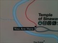 view gallery view gallerySE15.3 km |  Riverside Walk Map - Zion NP, UT Riverside Walk Map - Zion NP, UT
in 'You Are Here' Maps This map is at the bus stop for the Riverside Walk. posted by: bluesnote location: Utah date approved: 02/14/2014 last visited: 02/26/2016 |
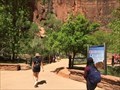 view gallery view gallerySE15.3 km |  Gateway to the Narrows Trail - Springdale, UT Gateway to the Narrows Trail - Springdale, UT
in Hiking and walking trailheads The Gateway to the Narrows Trail is a small trail that ends at the beginning to the Zion Narrows. It's about 1 mile in length. The above coordinates are for the trailhead for the Gateway. posted by: bluesnote location: Utah date approved: 04/02/2021 last visited: 04/02/2021 |
 view gallery view gallerySE15.3 km |  Gateway to the Narrows Trail - Springdale, UT Gateway to the Narrows Trail - Springdale, UT
in U.S. National Register of Historic Places The Gateway to the Narrows Trail is a small trail that ends at the beginning to the Zion Narrows. It's about 1 mile in length. The above coordinates are for the trailhead for the Gateway. posted by: bluesnote location: Utah date approved: 05/28/2018 last visited: 09/30/2020 |
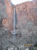 view gallery view gallerySE15.4 km |  The Narrows Waterfall - Zion National Park The Narrows Waterfall - Zion National Park
in Waterfalls This is the first waterfall north of the parking area. Hass paved walkway. posted by: ChapterhouseInc location: Utah date approved: 05/29/2011 last visited: 11/19/2018 |
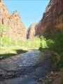
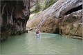
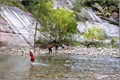 view gallery view gallerySE15.4 km |  Zion Narrows Zion Narrows
in Scenic Hikes The hike up from the parking/tram stop is paved and handicapped accessable up to a point. After that the trail enters the river and you can continue up the river as far as you want to go. Be prepared to get wet, very wet (chest level at times) if you continue beyond the paved portion. posted by: TerryDad2 location: Utah date approved: 08/11/2006 last visited: 07/26/2023 |
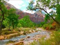 view gallery view gallerySE15.4 km |  Virgin River - Springdale, UT Virgin River - Springdale, UT
in Wikipedia Entries The Virgin River begins in Zion National Park and ends at the Colorado River in Nevada. The above coordinates are for the trailhead to the Zion Narrows, the most popular spot of the Virgin River where there are many slot canyons to hike into. posted by: bluesnote location: Utah date approved: 03/26/2021 last visited: 03/26/2021 |
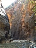
 view gallery view gallerySE15.4 km | Zion Narrows in Places of Geologic Significance The Zion Narrows is an impressive geomporpholical feature called a slot canyon. At its narrowest near Orderville Canyon further up river, the narrows is only 16 feet wide and 1000 feet deep. posted by: TerryDad2 location: Utah date approved: 01/30/2007 last visited: 10/19/2014 |
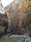 view gallery view gallerySE15.4 km |  The Zion Narrows - Springdale, UT The Zion Narrows - Springdale, UT
in Official Local Tourism Attractions Located in the back of Zion National Park is one of the most scenic hiking in the world, but only if you like to get wet. posted by: bluesnote location: Utah date approved: 03/26/2021 last visited: 07/28/2023 |
 view gallery view gallerySE15.4 km | Zion National Park - Zion Narrows in National Parks of the World During the peak season you will need to take the shuttle up to the coordinates. The coordinates are only the starting of the trail to the location of the Earthcache. Follow the trail up the canyon to the narrows. posted by: TerryDad2 location: Utah date approved: 08/24/2006 last visited: 07/28/2023 |
 view gallery view gallerySE15.4 km |  Virgin River - Zion National Park - Springdale, UT Virgin River - Zion National Park - Springdale, UT
in National Wild and Scenic Rivers The Virgin River begins in Zion National Park and ends at the Colorado River in Nevada. The above coordinates are for the trailhead to the Zion Narrows, the most popular spot of the Virgin River where there are many slot canyons to hike into. posted by: bluesnote location: Utah date approved: 02/22/2016 last visited: 07/28/2023 |
 view gallery view gallerySE15.4 km | The Zion Narrows - Springdale, UT in Wikipedia Entries Located in the back of Zion National Park is one of the most scenic hiking in the world, but only if you like to get wet. posted by: bluesnote location: Utah date approved: 02/20/2016 last visited: 07/28/2023 |
 view gallery view gallerySE16.3 km | Observation Point in U.S. Benchmarks This is an elevation benchmark on the rim of Observation Point in Zion National Park. posted by: UncleFester98 location: Utah date approved: 11/29/2005 last visited: 03/08/2015 |
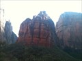
 view gallery view gallerySE16.4 km |  Zion National Park Zion National Park
in Established Rock Climbing Areas There are many climbing areas in the park. Permits and regulations apply. posted by: ChapterhouseInc location: Utah date approved: 05/28/2011 last visited: 11/17/2023 |
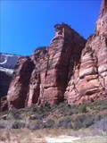
 view gallery view gallerySE16.4 km |  Big Bend - Zion National Park Big Bend - Zion National Park
in Ansel Adams Photo Hunt The National Park Service has thoughfully placed a small parking lot near this photogenic site. posted by: Go Boilers! location: Utah date approved: 12/02/2009 last visited: 11/17/2023 |
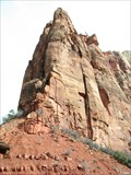
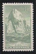 view gallery view gallerySE16.7 km |  The Great White Throne, Zion National Park, Utah The Great White Throne, Zion National Park, Utah
in Philatelic Photographs This massive sandstone monolith, known as the Great White Throne, rises nearly 2400 feet above the canyon floor in Utah's Zion National Park. posted by: hykesj location: Utah date approved: 11/02/2012 last visited: 09/30/2020 |
 view gallery view gallerySE16.7 km | Angels Landing - Zion NP, UT in Wikipedia Entries One of the most iconic rock features of the park. posted by: bluesnote location: Utah date approved: 02/15/2014 last visited: 09/30/2020 |
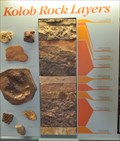 view gallery view galleryW16.9 km |  Kolob Rock Layers Kolob Rock Layers
in Rock and Mineral Displays This display graphically the rock layers that make up the Kolob Canyons area of Zion National park. posted by: brwhiz location: Utah date approved: 04/02/2012 last visited: 08/05/2014 |
 view gallery view galleryW16.9 km |  Kolob Canyons, Zion National Park - Cedar City, UT -- Visitors Center Kolob Canyons, Zion National Park - Cedar City, UT -- Visitors Center
in NPS Passport Cancellation Stations A small subsection of Zion National Park located 2 miles off of I-15 posted by: gparkes location: Utah date approved: 12/09/2008 last visited: 11/17/2023 |
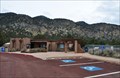 view gallery view galleryW16.9 km |  Kolob Canyons Visitor Center ~ Zion National Park Kolob Canyons Visitor Center ~ Zion National Park
in Ranger Stations This National Park Service Ranger Station and Visitor Center is at the access to the Kolob Canyons portion of Zion National Park. posted by: brwhiz location: Utah date approved: 04/02/2012 last visited: 11/17/2023 |
|