 view gallery view gallery NE17.1 km NE17.1 km
|   Four Roses Four Roses
in Wikipedia Entries The coordinates take you to the Four Roses Bourbon distillery. posted by:  Lord Elwood Lord Elwood location: Kentucky date approved: 09/01/2011 last visited: 07/07/2010 |
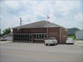
 view gallery view galleryNE17.1 km |  Four Roses Bourbon Distillery Four Roses Bourbon Distillery
in Breweries Welcome to the Four Roses Bourbon Distillery. posted by: Lord Elwood location: Kentucky date approved: 09/08/2010 last visited: 02/12/2018 |
 view gallery view gallery N23.8 km N23.8 km
|  Gravel Switch, KY Post Office - 40328 Gravel Switch, KY Post Office - 40328
in U.S. Post Offices This post office is located at 885 Gravel Switch Rd in the rural town of Gravel Switch, KY in Marion County. posted by: VQ9JC location: Kentucky date approved: 08/22/2013 last visited: never |
 view gallery view gallery W26.7 km W26.7 km
|  Taylor Regional Hospital, Campbellsville , Kentucky Taylor Regional Hospital, Campbellsville , Kentucky
in Hospitals A regional hospital serving the community of Campbellsville, Kentucky and is an associated hospital of the Jewish Hospital Health Network. posted by: PersonsMD location: Kentucky date approved: 03/20/2010 last visited: 03/18/2010 |
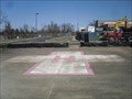
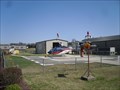 view gallery view galleryW26.7 km |  Taylor Regional Hospital Landing Pad, Campbellsville, Kentucky Taylor Regional Hospital Landing Pad, Campbellsville, Kentucky
in Helicopter Landing Pads Located at the Taylor Regional Hospital in Campbellsville, Kentucky, this landing pad provides emergency transport and first responder services for the regions citizens. This is also the base of operations for the Air Evac Lifeteam. posted by: PersonsMD location: Kentucky date approved: 03/19/2010 last visited: 03/18/2010 |
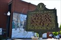 view gallery view galleryW27.7 km |  COURTHOUSE BURNED COURTHOUSE BURNED
in Kentucky Historical Markers COURTHOUSE BURNED Campbellsville,Kentucky posted by: ReedKyCacheFinders location: Kentucky date approved: 05/18/2013 last visited: 05/25/2013 |
 view gallery view galleryW27.7 km | BRIG. GEN. ELIAS BARBEE in Kentucky Historical Markers BRIG. GEN. ELIAS BARBEE ...on Broadway, Campbellsville,Kentucky Courthouse lawn, US 68 posted by: ReedKyCacheFinders location: Kentucky date approved: 05/18/2013 last visited: 05/25/2013 |
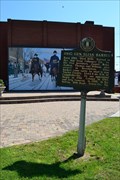
 view gallery view galleryW27.7 km | Confederate Raids in Kentucky Historical Markers CONFEDERATE RAIDS
Campbellsville,Kentucky on the Courthouse lawn, US 68 posted by: ReedKyCacheFinders location: Kentucky date approved: 05/18/2013 last visited: 05/25/2013 |
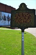
 view gallery view galleryW27.7 km | CAMPBELLSVILLE / TAYLOR COUNTY in Kentucky Historical Markers CAMPBELLSVILLE in Campbellsville,Kentucky on Courthouse lawn, US 68 posted by: ReedKyCacheFinders location: Kentucky date approved: 05/18/2013 last visited: 05/25/2013 |
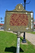 view gallery view galleryW27.7 km | Cumberland Trace in Kentucky Historical Markers CUMBERLAND TRACE in Campbellsville,Kentucky on the Courthouse lawn, US 68, KY 55 posted by: ReedKyCacheFinders location: Kentucky date approved: 05/18/2013 last visited: 05/25/2013 |
 view gallery view galleryW28 km | Campbellsville College in Kentucky Historical Markers CAMPBELLSVILLE COLLEGE
Entrance to campus, 200 W. College St., Campbellsville posted by: ReedKyCacheFinders location: Kentucky date approved: 05/18/2013 last visited: 05/14/2013 |
 view gallery view gallery NW29.3 km NW29.3 km
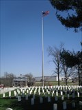
|  Lebanon National Cemetery, Lebanon, Kentucky Lebanon National Cemetery, Lebanon, Kentucky
in Worldwide Cemeteries Established in 1862 as a cemetery for Union Camp Crittenden the cemetery near Lebanon, Kentucky became a National Cemetery in 1867. Placed on the National Register of Historic Places in 1975. Final resting place of 3,000 - 4,000 soldiers. posted by: PersonsMD location: Kentucky date approved: 03/21/2010 last visited: 03/18/2010 |
 view gallery view galleryNW29.3 km |  Lebanon National Cemetery, Lebanon, Kentucky Lebanon National Cemetery, Lebanon, Kentucky
in Veteran Cemeteries Established in 1862 as a cemetery for Union Camp Crittenden the cemetery near Lebanon, Kentucky became a National Cemetery in 1867. Placed on the National Register of Historic Places in 1975 and in the 1980’s land donations expanded the cemetery. posted by: PersonsMD location: Kentucky date approved: 03/21/2010 last visited: 03/18/2010 |
 view gallery view galleryNW29.3 km |  Lebanon National Cemetery, Lebanon, Kentucky Lebanon National Cemetery, Lebanon, Kentucky
in U.S. National Register of Historic Places Established in 1862 as a cemetery for Union Camp Crittenden the cemetery near Lebanon, Kentucky became a National Cemetery in 1867. Placed on the National Register of Historic Places in 1975 and in the 1980’s land donations expanded the cemetery. posted by: PersonsMD location: Kentucky date approved: 03/20/2010 last visited: 03/18/2010 |
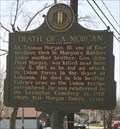 view gallery view galleryNW29.9 km | Death of a Morgan in Kentucky Historical Markers A marker noting the death of Lt. Thomas Morgan during the civil war one of the Morgan Raiders. Located in Lebanon, Kentucky on Highway 68. posted by: PersonsMD location: Kentucky date approved: 03/19/2010 last visited: 03/18/2010 |
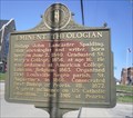 view gallery view galleryNW30.1 km | Eminent Theologian in Kentucky Historical Markers A marker noting the significance of theologian Bishop John Lancaster Spalding who organized the first black parish in 1866. Located in Lebanon, Kentucky. posted by: PersonsMD location: Kentucky date approved: 03/19/2010 last visited: 03/18/2010 |
 view gallery view galleryNW30.4 km | Spring View Hospital Landing Pad, Lebanon, Kentucky in Helicopter Landing Pads Located at the home of the Spring View Hospital in Lebanon, Kentucky, this landing pad provides emergency transport and first responder services for the regions citizens. posted by: PersonsMD location: Kentucky date approved: 03/19/2010 last visited: 03/18/2010 |
 view gallery view galleryNW30.4 km | Spring View Hospital, Lebanon, Kentucky in Hospitals A small regional hospital providing service to the citizens in the Lebanon, Kentucky area. Established in 1944 the hospital provides up to date care and services for the community. posted by: PersonsMD location: Kentucky date approved: 03/19/2010 last visited: 03/18/2010 |
 view gallery view gallery SW31.5 km SW31.5 km
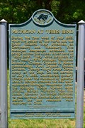
|  MICHIGAN AT TEBBS BEND MICHIGAN AT TEBBS BEND
in Michigan Historical Markers MICHIGAN AT TEBBS BEND in CAMPBELLSVILLE, KENTUCKY posted by: ReedKyCacheFinders location: Kentucky date approved: 05/17/2013 last visited: 05/17/2013 |
 view gallery view gallerySW31.5 km | Independence Day-1863 in Kentucky Historical Markers Independence Day-1863
9 mi. S. of Campbellsville,Kentucky on the Bypass on old KY 55 posted by: ReedKyCacheFinders location: Kentucky date approved: 05/18/2013 last visited: 05/14/2013 |
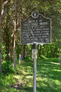 view gallery view gallerySW31.5 km | Battle of Green River Bridge in Kentucky Historical Markers Battle of Green River Bridge
9 mi. S. of Campbellsville, Bypass on Old KY 55 posted by: ReedKyCacheFinders location: Kentucky date approved: 05/18/2013 last visited: 05/14/2013 |
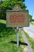
 view gallery view galleryN33.5 km | Site of First Rural Electric Co-Op Substation in County in Kentucky Historical Markers Energize 56 miles of line to 115 homes. posted by:  krsmith2 krsmith2 location: Kentucky date approved: 09/05/2013 last visited: never |
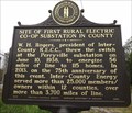 view gallery view galleryN33.5 km |  Site of First Rural Electric Co-Op Substation in County Site of First Rural Electric Co-Op Substation in County
in First of its Kind Perryville substation online 06/10/1938. posted by: krsmith2 location: Kentucky date approved: 09/05/2013 last visited: never |
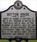 view gallery view galleryN33.8 km | Bottom House, Perryville, Kentucky in Kentucky Historical Markers Bottom family home durning civil war battle. posted by: krsmith2 location: Kentucky date approved: 09/03/2013 last visited: never |
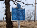 view gallery view galleryN33.8 km | Crawford Springs in Kentucky Historical Markers Key water source during the Civil Way Battle of Perryville. posted by: Wallyum location: Kentucky date approved: 03/25/2011 last visited: 08/18/2013 |
|