 view gallery view gallery W1.9 km W1.9 km
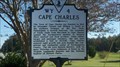
|   Cape Charles Cape Charles
in Virginia Historical Markers WY 4 CAPE CHARLES posted by:  southtexas southtexas location: Virginia date approved: 02/23/2013 last visited: 04/19/2022 |
 view gallery view gallery SE2.6 km SE2.6 km
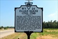
| Elijah Baker (1742-1798) in Virginia Historical Markers Baptist preacher who was the last to be jailed for peaching in Virginia. posted by: Markerman62 location: Virginia date approved: 08/03/2020 last visited: 07/30/2020 |
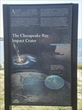 view gallery view galleryW3.4 km |  Chesapeake Bay Impact Crater Chesapeake Bay Impact Crater
in Impact Craters This impact crater is located in Chesapeake Bay area. The coords. are for the Chesapeake Bay Impact Crater sign. These are also the coords. for an earthcache. The sign has some missing information so the answers to the earthcache are not revealed. posted by:  Team Min Dawg Team Min Dawg location: Virginia date approved: 09/19/2007 last visited: 12/22/2013 |
 view gallery view gallery S5.3 km S5.3 km
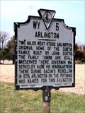
| Arlington in Virginia Historical Markers Along US 13 east of the former Arlington house and the Arlington community. posted by: Markerman62 location: Virginia date approved: 01/31/2015 last visited: 03/27/2015 |
 view gallery view gallery NE5.3 km NE5.3 km
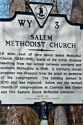
| Salem Methodist Church in Virginia Historical Markers Site of a violent division between Methodists. posted by: Markerman62 location: Virginia date approved: 01/30/2015 last visited: 09/23/2019 |
 view gallery view gallery N10.1 km N10.1 km
|  Eastville, VA Eastville, VA
in U.S. Post Offices U.S. Post Office, Eastville, VA posted by: wilsonjw location: Virginia date approved: 09/06/2017 last visited: never |
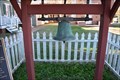 view gallery view galleryN10.3 km |  Northampton Courthouse Bell - Eastville, Va. Northampton Courthouse Bell - Eastville, Va.
in Bells The original Northampton County Courthouse Bell is located on the courthouse square in the Village of Eastville, Virginia. posted by: Sneakin Deacon location: Virginia date approved: 07/27/2020 last visited: never |
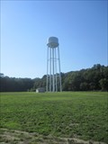 view gallery view galleryN10.3 km |  County Jail Water Tower County Jail Water Tower
in Water Towers Standard white elevated tank supported by a four leg frame located adjacent to the Northhampton country jail property. posted by: max771 location: Virginia date approved: 07/09/2011 last visited: never |
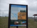
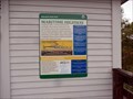 view gallery view galleryS10.9 km |  Maritime Highway-Kiptopeke State Park - Cape Charles VA Maritime Highway-Kiptopeke State Park - Cape Charles VA
in Signs of History Shipping traffic, commercial fisheries, recreation and tourism industries and the military rely on the Chesapeake Bay for its logistic potential. posted by: Don.Morfe location: Virginia date approved: 09/05/2020 last visited: 11/23/2021 |
 view gallery view galleryS10.9 km | Farm to Market-Kiptopeke State Park - Cape Charles VA in Signs of History The Eastern Shore has a rich agricultural history--from large British land grant farms to post-civil war tenant farmers and from large commercial outfits to small organic farms. posted by: Don.Morfe location: Virginia date approved: 09/05/2020 last visited: 09/26/2021 |
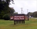
 view gallery view galleryS11.1 km |  Kiptopeke State Park - Cape Charles, VA Kiptopeke State Park - Cape Charles, VA
in Wikipedia Entries Kiptopeke State Park is located at 3540 Kiptopeke Dr, Cape Charles, VA 23310 posted by: Don.Morfe location: Virginia date approved: 09/21/2023 last visited: 09/21/2023 |
 view gallery view galleryS11.1 km |  Coin-Op Binoculars at Kiptopeke State Park - Cape Charles, VA Coin-Op Binoculars at Kiptopeke State Park - Cape Charles, VA
in Coin-Op Binoculars The Coin-Op Binoculars are in Kiptopeke State Park, 3540 Kiptopeke Drive, Cape Charles, VA 23310 posted by: Don.Morfe location: Virginia date approved: 09/21/2023 last visited: 09/21/2023 |
 view gallery view galleryS11.1 km |  Kiptopeke State Park - Cape Charles, VA Kiptopeke State Park - Cape Charles, VA
in Official Local Tourism Attractions Kiptopeke State Park is located at 3540 Kiptopeke Dr, Cape Charles, VA 23310 posted by: Don.Morfe location: Virginia date approved: 09/21/2023 last visited: 09/22/2023 |
 view gallery view galleryS11.1 km |  Kiptopeke State Park - Cape Charles, VA Kiptopeke State Park - Cape Charles, VA
in State/Provincial Parks Kiptopeke State Park is located at 3540 Kiptopeke Dr, Cape Charles, VA 23310 posted by: Don.Morfe location: Virginia date approved: 09/21/2023 last visited: 09/21/2023 |
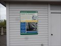
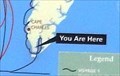 view gallery view galleryS11.1 km |  'You Are Here' Maps-Kiptopeke State Park - Cape Charles, VA 'You Are Here' Maps-Kiptopeke State Park - Cape Charles, VA
in 'You Are Here' Maps You Are Here' Map shows that you on the Captain John Smith Chesapeake National Historic Trail at Kiptopeke State Park, located at 3540 Kiptopeke Dr, Cape Charles, VA 23310 posted by: Don.Morfe location: Virginia date approved: 09/21/2023 last visited: 09/21/2023 |
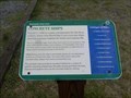
 view gallery view galleryS11.1 km | A Good Start Captain John Smith Chesapeake National Historic Trail in Signs of History On June 2, 1608, John Smith and his crew set sail on the first of two voyages exploring the Chesapeake region. Their first stop was the Eastern Shore. At a place near today’s Cape Charles, they saw Indian men fishing with spears. posted by: Don.Morfe location: Virginia date approved: 01/19/2020 last visited: 09/25/2021 |
 view gallery view galleryS11.1 km | Concrete Ships Kiptopeke State Park - Cape Charles, VA in Signs of History Placed in 1948 to create a breakwater for the ferry system, these nine World War II-era concrete ships provide a unique habitat for birds and marine life. posted by: Don.Morfe location: Virginia date approved: 01/19/2020 last visited: 06/03/2024 |
 view gallery view galleryS14.8 km |  Eastern Shore of Virginia National Wildlife Refuge Eastern Shore of Virginia National Wildlife Refuge
in National Public Lands Passport Locations Stamp can be found within the Visitor Center. posted by: luvthewood location: Virginia date approved: 05/29/2014 last visited: 09/22/2019 |
 view gallery view galleryS15 km |  Eastern Shore of Virginia National Wildlife Refuge - Cape Charles VA Eastern Shore of Virginia National Wildlife Refuge - Cape Charles VA
in National Wildlife Refuges This is one of the premier birding and wildlife sites on the Eastern Shore. Many consider the visitor center one of the finest in the national wildlife refuge system. posted by: Don.Morfe location: Virginia date approved: 01/05/2021 last visited: 10/24/2021 |
 view gallery view galleryS15 km |  Chesapeake Bay Bridge - Tunnel (North Parking Lot) Chesapeake Bay Bridge - Tunnel (North Parking Lot)
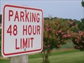
in Free Overnight RV Parking Locations North End Parking Lot Located in Northampton County near Cape Charles, VA posted by: fullxr location: Virginia date approved: 08/29/2012 last visited: 11/22/2018 |
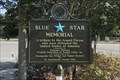 view gallery view galleryS15 km |  US 13, Chesapeake Bay Bridge Tunnel Rest Area Northern End, Kiptopeke, VA US 13, Chesapeake Bay Bridge Tunnel Rest Area Northern End, Kiptopeke, VA
in Blue Star Memorial Highway Markers A newer Blue Star Memorial in the rest area. posted by: Markerman62 location: Virginia date approved: 08/03/2020 last visited: 07/30/2020 |
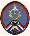 view gallery view galleryS15.3 km |  Cape Charles AFS Cape Charles AFS
in Abandoned Air Force Radar Sites Cape Charles AFS posted by: kJfishman location: Virginia date approved: 01/02/2008 last visited: 07/12/2014 |
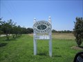 view gallery view galleryN21.4 km |  Chatham Winery Chatham Winery
in Wineries Chatham Vineyards is owned and operated by the Wehner family at historic Chatham Farm which has been a working farm for four centuries. Chatham Vineyards is located on Virginia's historic Eastern Shore. posted by: max771 location: Virginia date approved: 07/02/2011 last visited: 10/28/2018 |
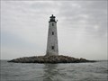 view gallery view galleryW26.2 km |  New Point Comfort Lighthouse New Point Comfort Lighthouse
in Coastal Lighthouses The New Point Comfort light, the third oldest light on the Bay, was built in 1804. It is located at the entrance to Mobjack Bay and the mouth of the York River in Mathews County, Virginia. posted by: chstress53 location: Virginia date approved: 10/07/2005 last visited: 11/02/2008 |
 W26.2 km | New Point Comfort Lighthouse in Coastal Lighthouses The New Point Comfort light, the third oldest light on the Bay, was built in 1804. It is located at the entrance to Mobjack Bay and the mouth of the York River in Mathews County, Virginia. posted by: chstress53 location: Virginia date approved: 10/06/2005 last visited: never |
|