 view gallery view gallery SW19.5 km SW19.5 km
|   First Dinkey Lake Eutrophication First Dinkey Lake Eutrophication
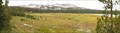
in Places of Geologic Significance First Dinkey Lake is a dieing lake. From the moment of its creation sediment has been slowly filling it in and it will one day become a meadow. This process is called eutrophication. posted by:  TerryDad2 TerryDad2 location: California date approved: 01/03/2010 last visited: never |
 view gallery view gallery E19.5 km E19.5 km
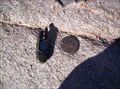
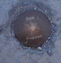
|  27_KSM 27_KSM
in U.S. Benchmarks Located on the shore near Loch Leven lake along the North Fork of Bishop Creek. It's about a four mile walk to this disk but well worth the views. posted by: Touchstone location: California date approved: 09/10/2006 last visited: 10/03/2008 |
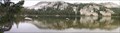 view gallery view gallerySW19.8 km | South Lake – A Cirque in Places of Geologic Significance The geomorphology of The Dinkey Lakes region has been largely created by the various glaciers that have covered the area. One of the landforms that the glaciers creates is a cirque. And when the cirque fills in with water it forms a tarn. posted by: TerryDad2 location: California date approved: 01/03/2010 last visited: never |
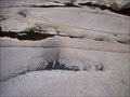 view gallery view gallerySW20 km | Dinky Creek Pluton in Places of Geologic Significance Recent theories of large granite futon formation start with the partial melting of a subducting plate. This magma rises up through fractures near the surface where the magma spreads out laterally along a horizontal fracture. posted by: TerryDad2 location: California date approved: 01/02/2010 last visited: never |
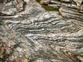 view gallery view gallerySW23.2 km | The Dinkey Creek Roof Pendant in Places of Geologic Significance The Dinkey Creek Roof Pendant is described as the remnant of a layer of meta-sediments that were above the Dinkey Creek Pluton that intruded underneath them. These rocks have been folded three different ways. posted by: TerryDad2 location: California date approved: 01/02/2010 last visited: never |
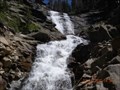 view gallery view gallery W23.3 km W23.3 km
|  Rancheria Falls Rancheria Falls
in Waterfalls Cascade falls at the end of a short trail. posted by: toponym location: California date approved: 07/25/2010 last visited: 04/06/2010 |
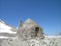 view gallery view gallery SE23.5 km SE23.5 km
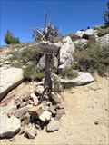
|  John Muir Memorial Shelter John Muir Memorial Shelter
in Remote Backcountry Shelters One of the most well known huts along the John Muir Trail. It is now only intended as an emergency survival shelter as general overnight traffic is prohibited. posted by: hyperheidi location: California date approved: 09/28/2011 last visited: never |
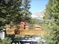
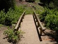 view gallery view galleryW24.5 km |  Rancheria Falls Trail foot bridge Rancheria Falls Trail foot bridge
in Hiking Path Footbridges A short bridge over a small creek on a short trail. posted by: toponym location: California date approved: 07/17/2010 last visited: never |
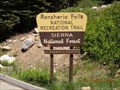 view gallery view galleryW24.5 km |  Rancheria Falls National Recreation Trail Rancheria Falls National Recreation Trail
in Hiking and walking trailheads A short trail to waterfalls. posted by: toponym location: California date approved: 07/20/2010 last visited: never |
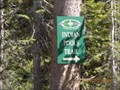 view gallery view galleryW24.6 km | Indian Pools Trail in Hiking and walking trailheads A short hike to a beautiful swimming hole. posted by: toponym location: California date approved: 07/18/2010 last visited: never |
 view gallery view gallery NE25.4 km NE25.4 km
| Rock Creek Lake - Bishop, CA in Hiking Path Footbridges This bridge at Rock Creek Lake spans the creek. There are walk-in campsites than can be accessed by crossing this bridge. posted by: Free2bme29 location: California date approved: 07/15/2009 last visited: 07/04/2009 |
 view gallery view galleryW26.6 km | Deer Creek Trailhead in Hiking and walking trailheads Located at the DF Pack Station, Deer Creek Road, Lakeshore, CA posted by: fresgo location: California date approved: 07/14/2013 last visited: never |
 view gallery view galleryW28.2 km |  Kaiser Peak Kaiser Peak
in Mountain Summits Kaiser Wilderness posted by: fresgo location: California date approved: 07/16/2013 last visited: never |
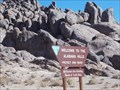 view gallery view galleryNE28.8 km |  Alabama Hills - Bishop, CA Alabama Hills - Bishop, CA
in Public Access Lands BLM lands west of HW395. 30,000 acres in Inyo County that show the range of volcanic formations. Visitors may apply for long term (2 wks.) camping. Bouldering is one of many reasons frequent the area. posted by:  sbcamper sbcamper location: California date approved: 11/01/2018 last visited: never |
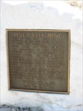 view gallery view galleryNE34.3 km |  Pine Creek Mine - Bishop, CA Pine Creek Mine - Bishop, CA
in E Clampus Vitus Historical Markers This has a nice view of the mountains. posted by: bluesnote location: California date approved: 04/19/2010 last visited: 04/19/2010 |
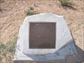 view gallery view galleryNE38.5 km | Owens Valley in E Clampus Vitus Historical Markers Marker located at Owens Valley Overlook on California's Highway 395 posted by: Bernd das Brot Team location: California date approved: 07/31/2010 last visited: 11/12/2013 |
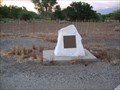 view gallery view galleryE39.3 km |  San Francis Ranch San Francis Ranch
in California Historical Markers A plaque noting Samuel Bishop's homesteading in the Bishop Area! posted by: fresgo location: California date approved: 07/28/2010 last visited: 04/14/2012 |
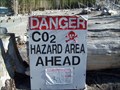 view gallery view gallery N42.5 km N42.5 km
| Horseshoe Lake Tree Kill in Places of Geologic Significance While Mammoth Mountain may not appear like an active volcano in the common sense, the dead and dying trees along Horseshoe Lake are being killed by the carbon dioxide released by volcanic activity. posted by: TerryDad2 location: California date approved: 01/01/2010 last visited: 08/19/2017 |
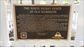 view gallery view galleryN42.8 km | The White Picket Fence at Old Mammoth in E Clampus Vitus Historical Markers A headstone of an early settler inside a white picket fence. posted by: Rumpled location: California date approved: 07/22/2019 last visited: never |
 view gallery view galleryN42.8 km | Twin Lakes/Mammoth Mountain Trailhead in Hiking and walking trailheads Accessed via Twin Lakes Campground, Inyo National Forest, Mammoth Lakes, CA. Parking is available in the Campground Day Use Area. posted by: fresgo location: California date approved: 04/04/2014 last visited: never |
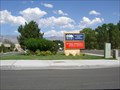 view gallery view galleryE43.1 km |  Northern Inyo Hospital - Bishop, CA Northern Inyo Hospital - Bishop, CA
in Hospitals This is a 25 bed, not for profit, accredited hospital. posted by: Free2bme29 location: California date approved: 07/08/2009 last visited: 05/13/2021 |
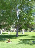 view gallery view galleryE43.1 km |  Norma V. Milici - Bishop, CA Norma V. Milici - Bishop, CA
in Dedicated Trees This tree dedicated to Norma is located in the Pioneer District Cemetery West. The marker reads IN MEMORY OF NORMA V. MILICY 8-23-26 4-2-93. posted by: Free2bme29 location: California date approved: 07/17/2009 last visited: 05/24/2011 |
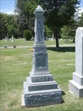 view gallery view galleryE43.3 km |  Shirley - Pioneer District Cemetery West - Bishop, CA Shirley - Pioneer District Cemetery West - Bishop, CA
in Zinc Headstones A zinc headstone in this Bishop cemetery. posted by: Free2bme29 location: California date approved: 07/06/2009 last visited: 05/24/2011 |
 view gallery view gallery NW43.5 km NW43.5 km
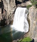
| Rainbow Falls, California in Waterfalls One of the most beautiful waterfalls in the Sierra Nevada posted by: Bernd das Brot Team location: California date approved: 04/13/2008 last visited: 04/06/2010 |
 view gallery view galleryNW43.6 km | Rainbow Falls STA 1 in U.S. Benchmarks This is at the Rainbow Falls, Mammoth, CA posted by: Team Ulogoit location: California date approved: 08/25/2008 last visited: never |
|