 view gallery view gallery SE9.3 km SE9.3 km
|   HB1513 - Caney 1957 HB1513 - Caney 1957
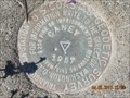
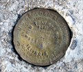
in U.S. Benchmarks A US COAST AND GEODETIC SURVEY TRIANGULATION STATION STAMPED CANEY 1957 NEAR LUCY JEFFERSON MONUMENT. posted by:  trailhound1 trailhound1 location: Kentucky date approved: 12/23/2011 last visited: 06/29/2011 |
 view gallery view gallerySE9.3 km |  Lucy Jefferson Lewis - Smithland, Kentucky Lucy Jefferson Lewis - Smithland, Kentucky
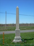
in Obelisks Obelisk dedicated to the memory of Lucy Jefferson Lewis, sister of President Thomas Jefferson, outside Smithland, Kentucky at the intersection of U.S. 60 and KY 137. posted by: trailhound1 location: Kentucky date approved: 07/07/2011 last visited: 07/08/2011 |
 view gallery view gallerySE9.3 km |  John Montgomery - Smithland, Kentucky John Montgomery - Smithland, Kentucky
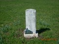
in Out of Place Graves Grave of Lieutenant Colonel John Montgomery located at the intersection of highways US 60 and KY 137 outside Smithland, Kentucky. posted by: trailhound1 location: Kentucky date approved: 07/10/2011 last visited: 07/08/2011 |
 view gallery view gallerySE9.3 km |  JEFFERSON'S SISTER JEFFERSON'S SISTER
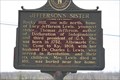
in Kentucky Historical Markers JEFFERSON'S SISTER on the intersection of hwy 60 and 137 in Livingston County, Kentucky posted by: ReedKyCacheFinders location: Kentucky date approved: 04/27/2009 last visited: 04/02/2011 |
 view gallery view gallery N13 km N13 km
| The Real Story of Mantle Rock - rural Livingston County, Kentucky in Kentucky Historical Markers This marker, sponsored by the National Park Service and the Nature Conservancy, is located outside the entrance of Mantle Rock Arch. This 215 acre property is located off Hwy 133 near Joy, Kentucky, in rural Livingston County. posted by: iconions location: Kentucky date approved: 11/13/2020 last visited: never |
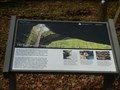 view gallery view galleryN13 km |  The Real Story of Mantle Rock - rural Livingston County, Kentucky The Real Story of Mantle Rock - rural Livingston County, Kentucky
in Trail of Tears This marker, sponsored by the National Park Service and the Nature Conservancy, is located outside the entrance of Mantle Rock Arch. This 215 acre property is located off Hwy 133 near Joy, Kentucky, in rural Livingston County. posted by: iconions location: Kentucky date approved: 11/17/2020 last visited: never |
 view gallery view galleryN13.2 km |  Mantle Rock Archeological District - near Joy, Kentucky Mantle Rock Archeological District - near Joy, Kentucky
in U.S. National Register of Historic Places This 215 acre property is located off Hwy 133 near Joy, Kentucky, in rural Livingston County. posted by: iconions location: Kentucky date approved: 11/13/2020 last visited: never |
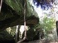 view gallery view galleryN13.2 km |  Mantle Rock / Livingston County Kentucky Mantle Rock / Livingston County Kentucky
in Natural Arches Mantle Rock Nature Preserve is a 30-foot high natural sandstone bridge spanning 188 feet. posted by: ReedKyCacheFinders location: Kentucky date approved: 09/12/2011 last visited: 11/05/2020 |
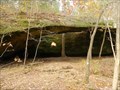 view gallery view galleryN13.2 km |  Mantle Rock Archeological District - near Joy, Kentucky Mantle Rock Archeological District - near Joy, Kentucky
in Wikipedia Entries This 215 acre property is located off Hwy 133 near Joy, Kentucky, in rural Livingston County. posted by: iconions location: Kentucky date approved: 11/12/2020 last visited: never |
 view gallery view gallerySE13.2 km |  Lucy Jefferson Lewis Bridge - Smithland, Kentucky Lucy Jefferson Lewis Bridge - Smithland, Kentucky
in Truss Bridges Lucy Jefferson Lewis Memorial (Smitland) Bridge is a through truss bridge located over the Cumberland River, on US 60 at Smithland, Kentucky. posted by: trailhound1 location: Kentucky date approved: 07/08/2011 last visited: 07/08/2011 |
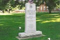
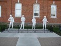 view gallery view galleryN13.4 km |  Pope County Veterans Memorial - Golconda, Illinois Pope County Veterans Memorial - Golconda, Illinois
in Non-Specific Veteran Memorials Veterans memorial on the grounds of the Pope County Courthouse in Golconda, Illinois. posted by:  BruceS BruceS location: Illinois date approved: 05/24/2009 last visited: never |
 view gallery view galleryN13.4 km |  Pope County Veterans Memorial - Golconda, Illinois Pope County Veterans Memorial - Golconda, Illinois
in Donated Engraved Bricks and Pavers Engraved bricks as part of veterans memorial on the grounds of the Pope County Courthouse in Golconda, Illinois. posted by: BruceS location: Illinois date approved: 05/23/2009 last visited: never |
 view gallery view galleryN13.4 km |  Lewis and Clark in Illinois ~ Golconda, IL Lewis and Clark in Illinois ~ Golconda, IL
in Lewis and Clark Trail One of a series of markers along the Ohio and Mississippi Rivers, and the Expedition made is way to the confluence of the Missouri and Mississippi Rivers. posted by: YoSam. location: Illinois date approved: 11/10/2009 last visited: never |
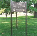 view gallery view galleryN13.4 km |  Lewis and Clark in Illinois ~ Golconda, IL Lewis and Clark in Illinois ~ Golconda, IL
in Illinois Historical Markers One of a series of markers along the Ohio and Mississippi Rivers, and the Expedition made is way to the confluence of the Missouri and Mississippi Rivers. posted by: YoSam. location: Illinois date approved: 11/10/2009 last visited: never |
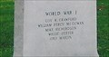 view gallery view galleryN13.4 km |  WWI - Pope County Veterans Memorial - Golconda, IL WWI - Pope County Veterans Memorial - Golconda, IL
in World War I Memorials and Monuments Part of a early memorial for wars between WWII and the Civil War. posted by: YoSam. location: Illinois date approved: 04/02/2017 last visited: never |
 view gallery view galleryN13.4 km | Pope County Veterans Memorial, Golconda, IL in Non-Specific Veteran Memorials Small Illinois river town, with huge and wide and tree covered courthouse lawn. posted by: YoSam. location: Illinois date approved: 07/06/2008 last visited: 04/11/2009 |
 view gallery view galleryN13.4 km |  Spanish-American War - Pope County Veterans Memorial - Golconda, IL Spanish-American War - Pope County Veterans Memorial - Golconda, IL
in Spanish-American War Memorials Part of a early memorial for wars between WWII and the Civil War. posted by: YoSam. location: Illinois date approved: 04/02/2017 last visited: never |
 view gallery view galleryN13.4 km |  Sarah Lusk - Golconda, Illinois Sarah Lusk - Golconda, Illinois
in Signs of History Historical marker honoring an early pioneering woman in southeast Illinois. posted by: BruceS location: Illinois date approved: 05/23/2009 last visited: 08/07/2006 |
 view gallery view galleryN13.4 km |  Sarah Lusk - Golconda, Illinois Sarah Lusk - Golconda, Illinois
in Citizen Memorials On the grounds of the Pope County Courthouse honoring an early pioneering woman in southeast Illinois. posted by: YoSam. location: Illinois date approved: 03/06/2014 last visited: never |
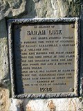 view gallery view galleryN13.4 km | Sarah Lusk - Golconda, Illinois in Illinois Historical Markers Historical marker on the grounds of the Pope County Courthouse honoring an early pioneering woman in southeast Illinois. posted by: BruceS location: Illinois date approved: 05/24/2009 last visited: 08/07/2006 |
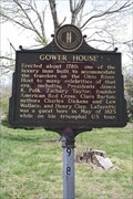 view gallery view gallerySE13.4 km | GOWER HOUSE/NED BUNTLINE in Kentucky Historical Markers GOWER HOUSE/ NED BUNTLINE ON THE RIVER FRONT IN LIVINGSTON COUNTY, KENTUCKY posted by: ReedKyCacheFinders location: Kentucky date approved: 04/25/2009 last visited: 07/16/2012 |
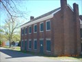 view gallery view gallerySE13.4 km | Gower House in U.S. National Register of Historic Places The Gower House located on Water Street in Smithland, Kentucky. posted by: trailhound1 location: Kentucky date approved: 07/09/2011 last visited: 07/08/2011 |
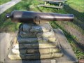 view gallery view galleryN13.4 km |  Pope County Courthouse Cannon - Golconda, Illinois Pope County Courthouse Cannon - Golconda, Illinois
in Static Artillery Displays Cannon on the grounds of the Pope County Courthouse in Golconda, Illinois. posted by: BruceS location: Illinois date approved: 05/29/2009 last visited: never |
 view gallery view galleryN13.4 km |  First ferry across the Ohio River - Golconda, IL First ferry across the Ohio River - Golconda, IL
in First of its Kind "Green's Ferry on the Mississippi as a plan to create business for the ferry. Sarah became the proprietor of the business, and in 1804 became the first woman in Illinois to obtain a ferry license, making the business legitimate." - Pope County posted by: YoSam. location: Illinois date approved: 03/03/2014 last visited: never |
 view gallery view galleryN13.4 km | PRIM TRAV STA N010 - Golconda, Illinois in U.S. Benchmarks Survey disk located at the northwest corner of Courthouse Square in Golconda, Illinois. posted by: BruceS location: Illinois date approved: 05/25/2009 last visited: never |
|