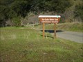
 view gallery view gallery E2.6 km E2.6 km
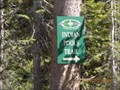
|   Indian Pools Trail Indian Pools Trail
in Hiking and walking trailheads A short hike to a beautiful swimming hole. posted by:  toponym toponym location: California date approved: 07/18/2010 last visited: never |
 view gallery view gallery N2.7 km N2.7 km
| Deer Creek Trailhead in Hiking and walking trailheads Located at the DF Pack Station, Deer Creek Road, Lakeshore, CA posted by: fresgo location: California date approved: 07/14/2013 last visited: never |
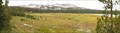
 view gallery view gallery NE3.1 km NE3.1 km
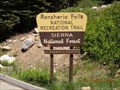
| Rancheria Falls National Recreation Trail in Hiking and walking trailheads A short trail to waterfalls. posted by: toponym location: California date approved: 07/20/2010 last visited: never |
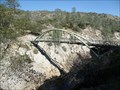
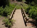 view gallery view galleryNE3.1 km |  Rancheria Falls Trail foot bridge Rancheria Falls Trail foot bridge
in Hiking Path Footbridges A short bridge over a small creek on a short trail. posted by: toponym location: California date approved: 07/17/2010 last visited: never |
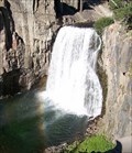
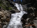 view gallery view galleryNE4.2 km |  Rancheria Falls Rancheria Falls
in Waterfalls Cascade falls at the end of a short trail. posted by: toponym location: California date approved: 07/25/2010 last visited: 04/06/2010 |
 view gallery view galleryN6.4 km |  Kaiser Peak Kaiser Peak
in Mountain Summits Kaiser Wilderness posted by: fresgo location: California date approved: 07/16/2013 last visited: never |
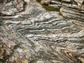 view gallery view gallery SE11.6 km SE11.6 km
|  The Dinkey Creek Roof Pendant The Dinkey Creek Roof Pendant
in Places of Geologic Significance The Dinkey Creek Roof Pendant is described as the remnant of a layer of meta-sediments that were above the Dinkey Creek Pluton that intruded underneath them. These rocks have been folded three different ways. posted by: TerryDad2 location: California date approved: 01/02/2010 last visited: never |
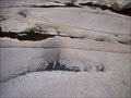 view gallery view gallerySE11.9 km | Dinky Creek Pluton in Places of Geologic Significance Recent theories of large granite futon formation start with the partial melting of a subducting plate. This magma rises up through fractures near the surface where the magma spreads out laterally along a horizontal fracture. posted by: TerryDad2 location: California date approved: 01/02/2010 last visited: never |
 view gallery view gallerySE13 km | First Dinkey Lake Eutrophication in Places of Geologic Significance First Dinkey Lake is a dieing lake. From the moment of its creation sediment has been slowly filling it in and it will one day become a meadow. This process is called eutrophication. posted by: TerryDad2 location: California date approved: 01/03/2010 last visited: never |
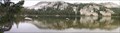 view gallery view gallerySE13.2 km | South Lake – A Cirque in Places of Geologic Significance The geomorphology of The Dinkey Lakes region has been largely created by the various glaciers that have covered the area. One of the landforms that the glaciers creates is a cirque. And when the cirque fills in with water it forms a tarn. posted by: TerryDad2 location: California date approved: 01/03/2010 last visited: never |
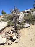
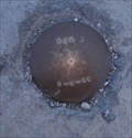
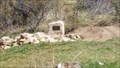 view gallery view gallery W25.1 km W25.1 km
|  True Center of California True Center of California
in U.S. Benchmarks Center of California as determined by CSU Fresno posted by: Clan_Armstrong location: California date approved: 03/09/2014 last visited: 07/30/2020 |
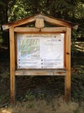
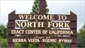 view gallery view galleryW29 km |  Geographical Center of California Geographical Center of California
in Geographical Centers This large wooden sign marks the geographical center of California. posted by:  NevaP NevaP location: California date approved: 05/24/2007 last visited: 07/30/2020 |
 view gallery view gallery SW31.4 km SW31.4 km
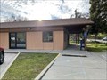
|  Tollhouse, CA - 93667 Tollhouse, CA - 93667
in U.S. Post Offices A post office in Tollhouse, CA. posted by: saopaulo1 location: California date approved: 03/02/2022 last visited: never |
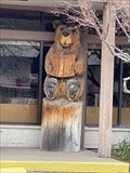 view gallery view gallerySW32.5 km |  Library Bear - Auberry, CA Library Bear - Auberry, CA
in Bear Statues A bear in front of the Auberry library. posted by: saopaulo1 location: California date approved: 02/16/2022 last visited: never |
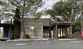
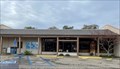 view gallery view gallerySW32.5 km |  Auberry Library - Auberry, CA Auberry Library - Auberry, CA
in Libraries The Auberry library in Fresno County. posted by: saopaulo1 location: California date approved: 02/14/2022 last visited: never |
 view gallery view gallerySW32.5 km | Auberry, CA - 93602 in U.S. Post Offices The post office in Auberry, CA. posted by: saopaulo1 location: California date approved: 03/02/2022 last visited: never |
 view gallery view gallerySW36.9 km | Pa'san Ridge Trail Footbridge in Hiking Path Footbridges Approximately 1 mile from the Ya-Gub-Weh-Tuh (Pa'san Ridge Trail) Trailhead. Located at the San Joaquin River Gorge Management Area in Fresno and Madera Counties, just north of Auberry, CA posted by: fresgo location: California date approved: 02/19/2013 last visited: never |
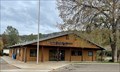
 view gallery view gallerySW37 km | Prather, CA - 93651 in U.S. Post Offices A post office in Prather, CA. posted by: saopaulo1 location: California date approved: 03/02/2022 last visited: never |
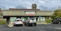 view gallery view gallerySW37 km |  Velasco's - Prather, CA Velasco's - Prather, CA
in Mexican Restaurants A Mexican restaurant in Prather, CA. posted by: saopaulo1 location: California date approved: 02/14/2022 last visited: never |
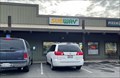 view gallery view gallerySW37.2 km |  Subway - Auberry - Prather, CA Subway - Auberry - Prather, CA
in Subway Restaurants A Subway in Prather, CA. posted by: saopaulo1 location: California date approved: 02/16/2022 last visited: never |
 view gallery view gallerySW37.2 km | Ya-Gub-Weh-Tuh (Pa'san Ridge Trail) Trailhead in Hiking and walking trailheads Located in the San Joaquin River Gorge, managed by the Bureau of Land Management near Auberry, California. A $5.00 Day Use Fee or the National Parks and Federal Recreational Lands Pass (available at usgs.gov) is required. posted by: fresgo location: California date approved: 02/17/2013 last visited: never |
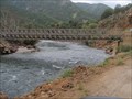 view gallery view gallery S40.9 km S40.9 km
|  Kings River Crossing Kings River Crossing
in Bailey Bridges Baily's Bridge crossing the Kings River posted by: kingsrafter location: California date approved: 07/01/2011 last visited: 05/06/2011 |
 view gallery view galleryN41.4 km | Rainbow Falls, California in Waterfalls One of the most beautiful waterfalls in the Sierra Nevada posted by:  Bernd das Brot Team Bernd das Brot Team location: California date approved: 04/13/2008 last visited: 04/06/2010 |
 view gallery view galleryN41.5 km | Rainbow Falls STA 1 in U.S. Benchmarks This is at the Rainbow Falls, Mammoth, CA posted by: Team Ulogoit location: California date approved: 08/25/2008 last visited: never |
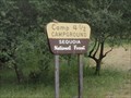 view gallery view galleryS41.8 km |  Camp 4 1/2 (Crazy Horse) Camp 4 1/2 (Crazy Horse)
in Campgrounds Perfect Cabin the Kings River. All you need to bring is Food and Linens. posted by: kingsrafter location: California date approved: 07/06/2011 last visited: 05/06/2011 |
|