 view gallery view gallery SW11.1 km SW11.1 km
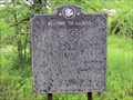
|   Welcome to Illinois Welcome to Illinois
in Illinois Historical Markers This "Welcome to Illinois" marker is on US45 North of the town of Brookport, across the river from Paducah, KY. Prior to the I-24 bridge, US45 and its bridge over the Ohio River was the main road into this part of Illinois. posted by:  NoLemon NoLemon location: Illinois date approved: 09/05/2006 last visited: 12/29/2018 |
 view gallery view gallerySW12.2 km |  George Roger Clark Discovery Trail - Strawberry Road George Roger Clark Discovery Trail - Strawberry Road
in Hiking and walking trailheads The Strawberry Road trailhead for the George Rogers Clark Discovery Trail. posted by:  trailhound1 trailhound1 location: Illinois date approved: 11/02/2016 last visited: never |
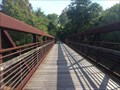
 view gallery view gallerySW12.2 km |  Sevenmile Creek Truss Superstructure Bridge Sevenmile Creek Truss Superstructure Bridge
in Truss Bridges A single span truss bridge crossing Sevenmile Creek along the George Rogers Clark Discovery Trail. posted by: trailhound1 location: Illinois date approved: 10/05/2016 last visited: never |
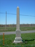 view gallery view gallery E12.2 km E12.2 km
|  Lucy Jefferson Lewis - Smithland, Kentucky Lucy Jefferson Lewis - Smithland, Kentucky
in Obelisks Obelisk dedicated to the memory of Lucy Jefferson Lewis, sister of President Thomas Jefferson, outside Smithland, Kentucky at the intersection of U.S. 60 and KY 137. posted by: trailhound1 location: Kentucky date approved: 07/07/2011 last visited: 07/08/2011 |
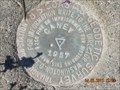 view gallery view galleryE12.4 km |  HB1513 - Caney 1957 HB1513 - Caney 1957
in U.S. Benchmarks A US COAST AND GEODETIC SURVEY TRIANGULATION STATION STAMPED CANEY 1957 NEAR LUCY JEFFERSON MONUMENT. posted by: trailhound1 location: Kentucky date approved: 12/23/2011 last visited: 06/29/2011 |
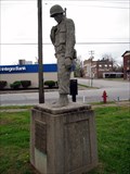 view gallery view gallerySW12.4 km |  Brookport World War II Memorial - Brookport, Illinois Brookport World War II Memorial - Brookport, Illinois
in World War II Memorials / Monuments World War II Memorial in Brookport, Illinois. posted by:  BruceS BruceS location: Illinois date approved: 05/26/2009 last visited: never |
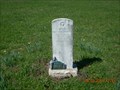 view gallery view galleryE12.4 km |  John Montgomery - Smithland, Kentucky John Montgomery - Smithland, Kentucky
in Out of Place Graves Grave of Lieutenant Colonel John Montgomery located at the intersection of highways US 60 and KY 137 outside Smithland, Kentucky. posted by: trailhound1 location: Kentucky date approved: 07/10/2011 last visited: 07/08/2011 |
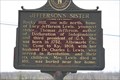 view gallery view galleryE12.4 km |  JEFFERSON'S SISTER JEFFERSON'S SISTER
in Kentucky Historical Markers JEFFERSON'S SISTER on the intersection of hwy 60 and 137 in Livingston County, Kentucky posted by: ReedKyCacheFinders location: Kentucky date approved: 04/27/2009 last visited: 04/02/2011 |
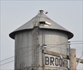
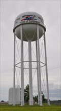
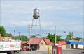 view gallery view gallerySW12.4 km |  Brookport Water Tower Brookport Water Tower
in Water Towers This Water Tower is located next to City Hall on the southwest corner of 3rd and Ohio Streets in downtown Brookport, Illinois. posted by: brwhiz location: Illinois date approved: 06/26/2013 last visited: never |
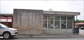
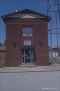 view gallery view gallerySW12.4 km |  Brookport Police Department / City Hall - Brookport, IL, Brookport Police Department / City Hall - Brookport, IL,
in Police Stations Located in Southern Illinois next to the Ohio River, Brookport is a community of around 1000 residents. To the southwest, Brookport is just minutes from downtown Paducah, Ky. About 10 miles to the northwest will put you in Metropolis, IL. posted by: blohm515 location: Illinois date approved: 06/18/2011 last visited: never |
 view gallery view gallerySW12.4 km | HB1549 ~ Brookport Municipal Tank in U.S. Benchmarks This US Benchmark is the apex at the top of the water tower located next to City Hall on the southwest corner of 3rd and Ohio Streets in downtown Brookport, Illinois. posted by: brwhiz location: Illinois date approved: 06/25/2013 last visited: never |
 view gallery view gallerySW12.4 km |  Brookport, Illinois ~ Population 1100 Brookport, Illinois ~ Population 1100
in Population Signs This Population Sign greets you as you enter Brookport from the south, immediately after you have crossed the Ohio River and passed from Kentucky into Illinois on the Sturgis-Ward Bridge (originally named the Paducah-Ohio River Bridge). posted by: brwhiz location: Illinois date approved: 06/25/2013 last visited: never |
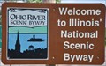 view gallery view gallerySW12.4 km |  Ohio River Scenic Byway (in Illinois) ~ Brookport Ohio River Scenic Byway (in Illinois) ~ Brookport
in National Scenic Byways Brookport is just one of the many historic towns that hug the bank of the Ohio River along its 188-mile travel along the southern border of Illinois. posted by: brwhiz location: Illinois date approved: 06/25/2013 last visited: never |
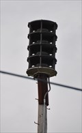 view gallery view gallerySW12.4 km |  Brookport Outdoor Warning Siren Brookport Outdoor Warning Siren
in Outdoor Warning Sirens This Outdoor Warning Siren is mounted on a pole behind the building immediately west of the water tower on the south side of 3rd Street in downtown Brookport, Illinois. posted by: brwhiz location: Illinois date approved: 07/04/2013 last visited: never |
 view gallery view gallerySW12.4 km |  Welcome to Illinois ~ The Land of Lincoln Welcome to Illinois ~ The Land of Lincoln
in Welcome Signs This Welcome Sign greets you almost immediately after you have crossed the Ohio River and passed from Kentucky into Illinois on your way from Paducah in Kentucky to Brookport on the Illinois side. posted by: brwhiz location: Illinois date approved: 07/02/2013 last visited: never |
 view gallery view gallerySW12.4 km |  Brookport, Illinois 62910 Brookport, Illinois 62910
in U.S. Post Offices This Post Office is located at 200 Ohio Street in Brookport, Illinois. posted by: brwhiz location: Illinois date approved: 06/26/2013 last visited: never |
 view gallery view gallery W13 km W13 km
| Metropolis "Home of Superman" Water Tower in Water Towers This Water Tower is located on the west side of Interstate Highway 24, north of Exit 37, near the end of Gurley Road (County Road 700N) northwest of Superman's hometown of Metropolis, Illinois. posted by: brwhiz location: Illinois date approved: 06/26/2013 last visited: never |
 view gallery view gallerySW13.2 km | Fourmile Creek Truss Superstructure Bridge in Truss Bridges A double span truss bridge crossing Fourmile Creek along the George Rogers Clark Discovery Trail. posted by: trailhound1 location: Illinois date approved: 10/04/2016 last visited: never |
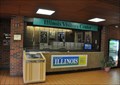 view gallery view gallerySW13.2 km |  Illinois Welcome Center Illinois Welcome Center
in Tourist Information Centers - Visitor Centers This Tourist Information Center is located in the Highway Rest Area at the southwest corner of Interstate Highway 24, Exit 37 on the eastern outskirts of Metropolis, Illinois. posted by: brwhiz location: Illinois date approved: 06/29/2013 last visited: 12/03/2021 |
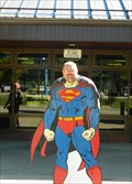 view gallery view gallerySW13.4 km |  I-24 Rest Area Cutout - near Metroplis, Il. I-24 Rest Area Cutout - near Metroplis, Il.
in Photo Cutouts A Superman Cutout located in front of the Tourist Information Station at the I-24 Rest Area near Metropolis, Illinois. posted by: iconions location: Illinois date approved: 10/31/2014 last visited: 12/12/2019 |
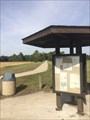
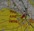 view gallery view gallerySW13.4 km |  Fort Massac Rest Area and Illinois Welcome Center Fort Massac Rest Area and Illinois Welcome Center
in 'You Are Here' Maps You Are Here at the Fort Massac Rest Area and Illinois Welcome Center located at the southwest corner of Interstate Highway 24, Exit 37 on the eastern outskirts of Metropolis, Illinois. posted by: brwhiz location: Illinois date approved: 07/28/2013 last visited: 06/14/2013 |
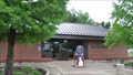 view gallery view gallerySW13.4 km |  Fort Massac Rest Area Fort Massac Rest Area
in Highway Rest Areas This Highway Rest Area is located at the southwest corner of Interstate Highway 24, Exit 37 on the eastern outskirts of Metropolis, Illinois. posted by: brwhiz location: Illinois date approved: 07/02/2013 last visited: 01/06/2022 |
 view gallery view gallerySW13.4 km | Fort Massac - I-24 Rest Area, Metropolis, IL in Illinois Historical Markers Inside the rest area tourism center is this marker. posted by: YoSam. location: Illinois date approved: 04/27/2014 last visited: never |
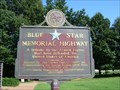 view gallery view gallerySW13.4 km |  I 24 Rest Stop, Metropolis, IL I 24 Rest Stop, Metropolis, IL
in Blue Star Memorial Highway Markers This Blue Star Memorial Highway Marker commemorates the George Rogers Clark Trail. posted by: snfromky location: Illinois date approved: 07/24/2006 last visited: 01/06/2022 |
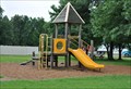 view gallery view gallerySW13.4 km |  Fort Massac Rest Area Playground Fort Massac Rest Area Playground
in Public Playgrounds This Public Playground is located in the Fort Massac Highway Rest Area at the southwest corner of Interstate Highway 24, Exit 37 on the eastern outskirts of Metropolis, Illinois. posted by: brwhiz location: Illinois date approved: 06/26/2013 last visited: 12/03/2021 |
|