 view gallery view gallery SW0.5 km SW0.5 km
|   Boavista Boavista
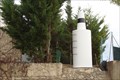
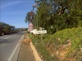
in Portugal Geodetic Points The mark by the local road. posted by:  Vedot67 Vedot67 location: Faro, Portugal date approved: 04/28/2012 last visited: never |
 view gallery view gallery E1.9 km E1.9 km
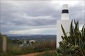
| Picota 2º in Portugal Geodetic Points Elevated area for sightseeing posted by: Vedot67 location: Faro, Portugal date approved: 04/28/2012 last visited: 12/06/2020 |
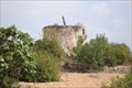
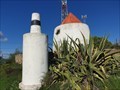 view gallery view galleryE1.9 km |  Moinho da Picota - Boliqueime, Portugal Moinho da Picota - Boliqueime, Portugal
in Windmills A windmill in the hamlet of Picota, Boliqueime, in southern Portugal posted by:  Torgut Torgut location: Faro, Portugal date approved: 12/08/2020 last visited: never |
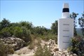
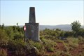
 view gallery view gallery S3.1 km S3.1 km
| Janela 2o in Portugal Geodetic Points The Mark on the top of a windmill posted by: Vedot67 location: Faro, Portugal date approved: 02/07/2012 last visited: 04/15/2019 |
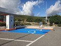 view gallery view gallery SE3.1 km SE3.1 km
|  A22 Estação de Serviço de Loulé - Loulé, Portugal A22 Estação de Serviço de Loulé - Loulé, Portugal
in Electric Car Charging Stations A charging station in a highway gas station near Loulé, in southern Portugal posted by: Torgut location: Faro, Portugal date approved: 11/09/2020 last visited: never |
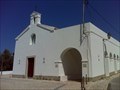 view gallery view galleryE3.4 km |  Igreja da Nossa Senhora da Boa Hora - Parragil, Portugal Igreja da Nossa Senhora da Boa Hora - Parragil, Portugal
in Roman Catholic Churches A small local church in the hamlet of Parragil posted by: Torgut location: Faro, Portugal date approved: 09/03/2015 last visited: never |
 view gallery view gallery NE3.7 km NE3.7 km
| Monte Seco in Portugal Geodetic Points Easy access by a dirt road. posted by: Vedot67 location: Faro, Portugal date approved: 06/21/2012 last visited: never |
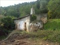 view gallery view gallery NW3.9 km NW3.9 km
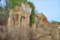
|  Lone building, Paderne, Portugal Lone building, Paderne, Portugal
in Unoccupied Buildings, Shacks, and Cabins An isolated building of unknown origin and role in Paderne area, south Portugal posted by: Torgut location: Faro, Portugal date approved: 01/27/2012 last visited: never |
 view gallery view gallerySE3.9 km |  Cimpor - Cimentos de Portugal, SGPS, SA Loulé - Loulé, Faro, Portugal Cimpor - Cimentos de Portugal, SGPS, SA Loulé - Loulé, Faro, Portugal
in Publicly Held Corporation Headquarters Cimpor - Cimentos de Portugal é o maior grupo de produção de cimento em Portugal. posted by: AlexCatarina location: Faro, Portugal date approved: 12/20/2015 last visited: never |
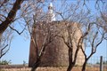
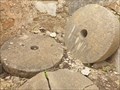 view gallery view galleryE4 km |  Moinho do Cerro do Alto - Loulé, Portugal Moinho do Cerro do Alto - Loulé, Portugal
in Millstones Three considerably sized millstones in an old windmill posted by: Torgut location: Faro, Portugal date approved: 03/26/2023 last visited: never |
 view gallery view gallery N4.2 km N4.2 km
| Cabeça Gorda in Portugal Geodetic Points In the agricultural area. posted by: Vedot67 location: Faro, Portugal date approved: 06/21/2012 last visited: never |
 view gallery view gallery W4.3 km W4.3 km
| Malhão 1º in Portugal Geodetic Points Abandoned windmill as a geodetic mark. posted by: Vedot67 location: Faro, Portugal date approved: 09/07/2012 last visited: never |
 view gallery view galleryE4.8 km |  Zambujeirão, Portugal Zambujeirão, Portugal
in 'Z' Welcome Signs Zambujeirão is a hamlet near Loulé, in Southern Portugal posted by: Torgut location: Faro, Portugal date approved: 12/17/2011 last visited: never |
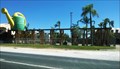 view gallery view galleryS5 km |  Watering Can - Loulé, Faro, Portugal Watering Can - Loulé, Faro, Portugal
in Ginormous Everyday Objects A giant "regador" in the Algarve region. posted by: RuiJSDuarte location: Faro, Portugal date approved: 07/13/2014 last visited: never |
 view gallery view galleryN5 km | Espargal in Portugal Geodetic Points A mark with excellent view from the top. posted by: Vedot67 location: Faro, Portugal date approved: 06/21/2012 last visited: never |
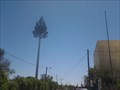 view gallery view galleryS5.3 km |  Pine Cell Tower - Vilamoura, Portugal Pine Cell Tower - Vilamoura, Portugal
in Disguised Cell Towers Pine shaped cell tower at the Av. Vilamoura XXI near Vilamoura. posted by: DosHermanas location: Faro, Portugal date approved: 06/11/2016 last visited: never |
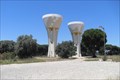 view gallery view galleryS5.5 km |  The Twin Towers of Vilamoura. The Twin Towers of Vilamoura.
in Water Towers These twin water towers can be seen towering over the upper part of Vilamoura. posted by: greysman location: Faro, Portugal date approved: 06/01/2011 last visited: 08/31/2009 |
 view gallery view gallerySE5.6 km | Pedra da Moura in Portugal Geodetic Points The mark by southern motorway A22 posted by: Vedot67 location: Faro, Portugal date approved: 02/07/2012 last visited: never |
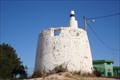
 view gallery view galleryW5.6 km |  Moinho da Alfarrobeira - Paderne, Portugal Moinho da Alfarrobeira - Paderne, Portugal
in Water Mills This water mill is located not far from a medieval castle and an ancient bridge, in southern Portugal posted by: Torgut location: Faro, Portugal date approved: 02/10/2021 last visited: never |
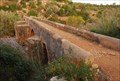 view gallery view galleryW5.8 km |  Ponte Medieval de Paderne, Algarve, Portugal Ponte Medieval de Paderne, Algarve, Portugal
in Stone Bridges A medieval bridge over the Quarteira stream. posted by: manchanegra location: Faro, Portugal date approved: 07/01/2011 last visited: 05/25/2012 |
 view gallery view galleryW5.8 km |  Ponte Medieval de Paderne, Algarve, Portugal Ponte Medieval de Paderne, Algarve, Portugal
in Arch Bridges A medieval bridge over the Quarteira stream. posted by: manchanegra location: Faro, Portugal date approved: 07/05/2011 last visited: 05/25/2012 |
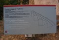 view gallery view galleryW5.8 km |  Ponte Medieval de Paderne - Algarve, Portugal Ponte Medieval de Paderne - Algarve, Portugal
in Portuguese Historical Markers A medieval bridge over the Quarteira stream. posted by: manchanegra location: Faro, Portugal date approved: 11/04/2011 last visited: 05/25/2012 |
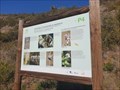 view gallery view galleryW5.8 km |  Estação da Biodiversidade da Ribeira de Quarteira P4 - Paderne, Portugal Estação da Biodiversidade da Ribeira de Quarteira P4 - Paderne, Portugal
in Flora and Fauna Information Signs This is Panel 4 of a 2 km hike focused in fauna and flora interpretation. Near Paderne, in Southern Portugal posted by: Torgut location: Faro, Portugal date approved: 02/11/2021 last visited: never |
 view gallery view gallerySE5.8 km |  Montes Algarvios, Loulé, Portugal Montes Algarvios, Loulé, Portugal
in Remains of Settlements The remains of a tiny hamlet posted by: Torgut location: Faro, Portugal date approved: 08/06/2012 last visited: never |
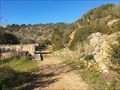
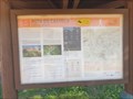 view gallery view galleryW6 km |  PR1 ABF Rota do Castelo - Paderne, Portugal PR1 ABF Rota do Castelo - Paderne, Portugal
in Hiking and walking trailheads A circular hiking trail of about 10 km bringing the hiker to a few historical sites amidst beautiful nature posted by: Torgut location: Faro, Portugal date approved: 02/12/2021 last visited: never |
|