 view gallery view gallery S0.5 km S0.5 km
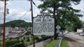
|   John Mullins John Mullins
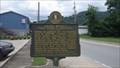
in Virginia Historical Markers A Virginia Historical Roadside Marker in Clintwood, Virginia. posted by:  Manville Possum Manville Possum location: Virginia date approved: 08/12/2013 last visited: 12/30/2019 |
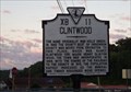 view gallery view gallery W1.4 km W1.4 km
| Clintwood in Virginia Historical Markers A Virginia Historical Roadside Marker in Clintwood, Virginia. posted by: Manville Possum location: Virginia date approved: 08/12/2013 last visited: 12/30/2019 |
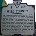 view gallery view galleryW8.4 km | Wise County / Dickenson County in Virginia Historical Markers A Virginia Historical Marker at the Wise and Dickenson County line. posted by: Manville Possum location: Virginia date approved: 09/02/2013 last visited: 12/30/2019 |
 view gallery view gallery SW14 km SW14 km
| Francis Gary Powers ~ U2 Pilot in Virginia Historical Markers A Virginia Department of Historical Resources roadside marker honoring Francis Gary Powers who was raised here in Pound and graduated from Grundy High School. posted by: Manville Possum location: Virginia date approved: 07/29/2013 last visited: 12/30/2019 |
 view gallery view galleryW14.8 km |  Pound Gap Engagement Pound Gap Engagement
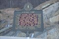
in U.S. Civil War Sites A Virginia Civil War Trails historical marker in Pound Gap. posted by:  Cecticide Cecticide location: Virginia date approved: 10/28/2021 last visited: 10/28/2021 |
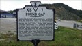 view gallery view galleryW15.4 km | Pound Gap in Virginia Historical Markers A Virginia Department of Historic Resources roadside marker along Highway US 23 near the Virginia and Kentucky borders in Pound Gap. posted by: Manville Possum location: Virginia date approved: 09/09/2013 last visited: 12/30/2019 |
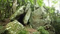 view gallery view galleryW15.4 km |  Mullins Massacre at Pound Gap ~ Killing Rock Mullins Massacre at Pound Gap ~ Killing Rock
in Infamous Crime Scenes Location in Virginia on the Pine Mountain Trail in Pound Gap near the Kentucky border known as Killing Rock where a family was murdered on May 14, 1892. posted by: Manville Possum location: Virginia date approved: 03/22/2014 last visited: 12/30/2019 |
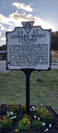 view gallery view galleryW15.4 km | Leonard Woods Lynched in Virginia Historical Markers A Virginia historical marker about Leonard Woods who was a black American man who was lynched by a mob in Pound Gap, on the border between Kentucky and Virginia, after they broke him out from jail in Whitesburg, Kentucky, on November 30, 1927. posted by: Manville Possum location: Virginia date approved: 10/16/2021 last visited: 10/17/2021 |
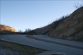
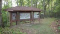 view gallery view galleryW15.6 km |  Pine Mountain Trailhead in Pound Gap ~ Jefferson National Forest Pine Mountain Trailhead in Pound Gap ~ Jefferson National Forest
in Hiking and walking trailheads Trailhead to the Pine Mountain Trail in Pound Gap. posted by: Manville Possum location: Virginia date approved: 09/21/2014 last visited: 12/30/2019 |
 view gallery view galleryW15.9 km |  Lt. Darwin K. Kyle Lt. Darwin K. Kyle
in Kentucky Historical Markers On S. Main St in Jenkins. posted by: Markerman62 location: Kentucky date approved: 04/08/2015 last visited: 04/08/2015 |
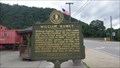
 view gallery view galleryW16.1 km | Pound Gap in Kentucky Historical Markers Pound Gap - Discovered in 1751, Location of US Civil War Conflict posted by: PersonsMD location: Kentucky date approved: 01/15/2009 last visited: 08/30/2013 |
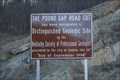
 view gallery view galleryW16.1 km |  Pound Gap, Jenkins, Kentucky Pound Gap, Jenkins, Kentucky
in Places of Geologic Significance Officially recognized as a "Distinguished Geologic Site" by the Kentucky Society of Professional Geologists, the area displays an extraordinary outcropping of nearly the entire section of Late Devonian, Mississippian & Early Pennsylvanian stratigraph posted by: PersonsMD location: Kentucky date approved: 01/03/2009 last visited: 07/28/2013 |
 view gallery view galleryW16.1 km |  Pound Gap - Jenkins, Kentucky Pound Gap - Jenkins, Kentucky
in Named Mountain Gaps A natural Gap with deep historical and geological significance located near Jenkins, Kentucky. Was first called "Sounding Gap" posted by: PersonsMD location: Kentucky date approved: 01/11/2009 last visited: 01/01/2009 |
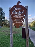 view gallery view galleryW16.1 km |  Combs Overlook ~ Jenkins, Kentucky - USA Combs Overlook ~ Jenkins, Kentucky - USA
in Scenic Overlooks Located in Pound Gap on the Kentucky side overlooking the town of Jenkins. posted by: Manville Possum location: Kentucky date approved: 10/26/2021 last visited: 10/26/2021 |
 view gallery view gallery NW17.9 km NW17.9 km
|  Dorton KY 41520 Post Office Dorton KY 41520 Post Office
in U.S. Post Offices Dorton KY Post Office posted by: dukemartin location: Kentucky date approved: 10/07/2017 last visited: never |
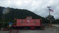 view gallery view gallery NE19.3 km NE19.3 km
|  Chesapeake & Ohio Caboose ~ CO 90256 ~ Elkhorn City, KY Chesapeake & Ohio Caboose ~ CO 90256 ~ Elkhorn City, KY
in Train Cabooses A Chesapeake & Ohio Caboose on public display in Elkhorn City, KY. posted by: Manville Possum location: Kentucky date approved: 06/26/2015 last visited: 12/30/2019 |
 view gallery view galleryNE19.3 km | William Ramey ~ Elkhorn City, KY in Kentucky Historical Markers A Kentucky Historical Marker for William Ramey in Elkhorn City placed by the Kentucky Historical Society and Kentucky Department of Highways. posted by: Manville Possum location: Kentucky date approved: 06/22/2015 last visited: 12/30/2019 |
 view gallery view galleryNE19.3 km | Daniel Boone's First Steps in Kentucky ~ Elkhorn City, KY in Kentucky Historical Markers A Kentucky Historical Marker about Daniel Boone's first steps in Kentucky, placed by the Kentucky Historical Society and Kentucky Department of Highways. posted by: Manville Possum location: Kentucky date approved: 06/22/2015 last visited: 12/30/2019 |
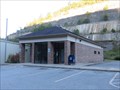
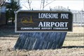 view gallery view galleryS19.5 km |  Lonesome Pine Airport, Wise, Virginia Lonesome Pine Airport, Wise, Virginia
in Airports An airport located in Wise county, Virginia posted by: PersonsMD location: Virginia date approved: 01/03/2009 last visited: 03/01/2014 |
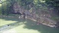 view gallery view galleryNE19.8 km |  Pool Point Pool Point
in Swimming Holes A swimming hole on the Russell Fork River near Breaks Interstate Park. posted by: Manville Possum location: Kentucky date approved: 08/22/2013 last visited: 12/30/2019 |
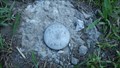 view gallery view galleryNE20 km |  Potter Flatts ~ CP-1 Potter Flatts ~ CP-1
in U.S. Benchmarks A survey marker along Kentucky State route 80 at the Russel Fork River access entrance. posted by: Manville Possum location: Kentucky date approved: 08/08/2013 last visited: 12/30/2019 |
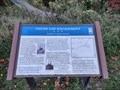
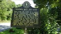 view gallery view galleryNE20.6 km | KNOWN BUT TO GOD in Kentucky Historical Markers A Kentucky Historical Marker placed in memory of a unknown solider of the CSA. posted by: Manville Possum location: Kentucky date approved: 08/01/2013 last visited: 12/30/2019 |
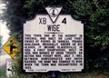 view gallery view gallerySW22 km | Wise in Virginia Historical Markers A descriptive account about the town of Wise that was originally called Big Glades and followed by Gladesville. posted by: Markerman62 location: Virginia date approved: 04/08/2015 last visited: 07/23/2016 |
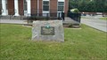 view gallery view gallerySW22 km |  Wise Municipal Building ~ Wise, Virginia. Wise Municipal Building ~ Wise, Virginia.
in Blue Star Memorial Highway Markers A Blue Star Memorial By-Way Marker in Wise, Virginia. posted by: Manville Possum location: Virginia date approved: 07/28/2016 last visited: 07/22/2017 |
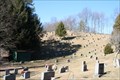 view gallery view gallerySW22.2 km |  Wise Cemetery; Wise, Wise County, Virginia Wise Cemetery; Wise, Wise County, Virginia
in Worldwide Cemeteries Cemetery located in the city and county of Wise Virginia. posted by: PersonsMD location: Virginia date approved: 01/09/2009 last visited: 03/22/2014 |
|