 view gallery view gallery E0.2 km E0.2 km
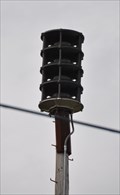
|   Brookport Outdoor Warning Siren Brookport Outdoor Warning Siren
in Outdoor Warning Sirens This Outdoor Warning Siren is mounted on a pole behind the building immediately west of the water tower on the south side of 3rd Street in downtown Brookport, Illinois. posted by:  brwhiz brwhiz location: Illinois date approved: 07/04/2013 last visited: never |
 view gallery view galleryE0.2 km |  HB1549 ~ Brookport Municipal Tank HB1549 ~ Brookport Municipal Tank
in U.S. Benchmarks This US Benchmark is the apex at the top of the water tower located next to City Hall on the southwest corner of 3rd and Ohio Streets in downtown Brookport, Illinois. posted by: brwhiz location: Illinois date approved: 06/25/2013 last visited: never |
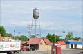 view gallery view galleryE0.2 km |  Brookport Water Tower Brookport Water Tower
in Water Towers This Water Tower is located next to City Hall on the southwest corner of 3rd and Ohio Streets in downtown Brookport, Illinois. posted by: brwhiz location: Illinois date approved: 06/26/2013 last visited: never |
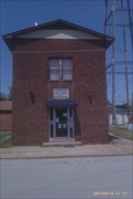 view gallery view galleryE0.2 km |  Brookport Police Department / City Hall - Brookport, IL, Brookport Police Department / City Hall - Brookport, IL,
in Police Stations Located in Southern Illinois next to the Ohio River, Brookport is a community of around 1000 residents. To the southwest, Brookport is just minutes from downtown Paducah, Ky. About 10 miles to the northwest will put you in Metropolis, IL. posted by:  blohm515 blohm515 location: Illinois date approved: 06/18/2011 last visited: never |
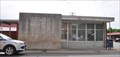 view gallery view galleryE0.2 km |  Brookport, Illinois 62910 Brookport, Illinois 62910
in U.S. Post Offices This Post Office is located at 200 Ohio Street in Brookport, Illinois. posted by: brwhiz location: Illinois date approved: 06/26/2013 last visited: never |
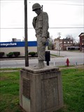 view gallery view galleryE0.2 km |  Brookport World War II Memorial - Brookport, Illinois Brookport World War II Memorial - Brookport, Illinois
in World War II Memorials / Monuments World War II Memorial in Brookport, Illinois. posted by:  BruceS BruceS location: Illinois date approved: 05/26/2009 last visited: never |
 view gallery view galleryE0.3 km |  Brookport, Illinois ~ Population 1100 Brookport, Illinois ~ Population 1100
in Population Signs This Population Sign greets you as you enter Brookport from the south, immediately after you have crossed the Ohio River and passed from Kentucky into Illinois on the Sturgis-Ward Bridge (originally named the Paducah-Ohio River Bridge). posted by: brwhiz location: Illinois date approved: 06/25/2013 last visited: never |
 view gallery view gallery SE0.3 km SE0.3 km
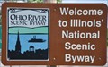
|  Ohio River Scenic Byway (in Illinois) ~ Brookport Ohio River Scenic Byway (in Illinois) ~ Brookport
in National Scenic Byways Brookport is just one of the many historic towns that hug the bank of the Ohio River along its 188-mile travel along the southern border of Illinois. posted by: brwhiz location: Illinois date approved: 06/25/2013 last visited: never |
 view gallery view gallerySE0.3 km |  Welcome to Illinois ~ The Land of Lincoln Welcome to Illinois ~ The Land of Lincoln
in Welcome Signs This Welcome Sign greets you almost immediately after you have crossed the Ohio River and passed from Kentucky into Illinois on your way from Paducah in Kentucky to Brookport on the Illinois side. posted by: brwhiz location: Illinois date approved: 07/02/2013 last visited: never |
 view gallery view gallery S1.1 km S1.1 km
|  Irvin S. Cobb Bridge - Paducah, KY Irvin S. Cobb Bridge - Paducah, KY
in Truss Bridges The Irvin S Cobb Bridge is also known as the Brookport Bridge. posted by: nomadwillie location: Kentucky date approved: 03/17/2013 last visited: never |
 view gallery view gallery N1.8 km N1.8 km
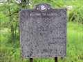
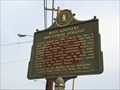
|  Welcome to Illinois Welcome to Illinois
in Illinois Historical Markers This "Welcome to Illinois" marker is on US45 North of the town of Brookport, across the river from Paducah, KY. Prior to the I-24 bridge, US45 and its bridge over the Ohio River was the main road into this part of Illinois. posted by: NoLemon location: Illinois date approved: 09/05/2006 last visited: 12/29/2018 |
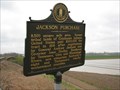 view gallery view galleryS2.1 km |  Jackson Purchase - Paducah, Kentucky Jackson Purchase - Paducah, Kentucky
in Kentucky Historical Markers Historical marker of commemorating a large tract of land forming portions of both Kentucky and Tennessee. posted by: BruceS location: Kentucky date approved: 05/23/2009 last visited: 01/19/2013 |
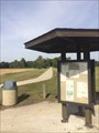 view gallery view gallery NW2.6 km NW2.6 km
|  George Roger Clark Discovery Trail - Strawberry Road George Roger Clark Discovery Trail - Strawberry Road
in Hiking and walking trailheads The Strawberry Road trailhead for the George Rogers Clark Discovery Trail. posted by: trailhound1 location: Illinois date approved: 11/02/2016 last visited: never |
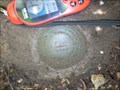
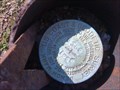 view gallery view galleryS2.9 km | HB0359 - U 389 in U.S. Benchmarks A US COAST AND GEODETIC SURVEY STANDARD DISK CEMENTED IN A DRILL HOLE SET ON THE TOP OF A COPPER COATED ROD THAT IS ENCASED IN A CAST IRON PIPE WHICH PROJECTS 6 INCHES. posted by: trailhound1 location: Kentucky date approved: 06/30/2011 last visited: 06/29/2011 |
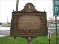 view gallery view galleryS2.9 km | Paducah, Kentucky in Kentucky Historical Markers Historical marker giving a brief history of City of Paducah and McCracken County. posted by: BruceS location: Kentucky date approved: 05/13/2009 last visited: 04/06/2014 |
 view gallery view galleryNW2.9 km | Sevenmile Creek Truss Superstructure Bridge in Truss Bridges A single span truss bridge crossing Sevenmile Creek along the George Rogers Clark Discovery Trail. posted by: trailhound1 location: Illinois date approved: 10/05/2016 last visited: never |
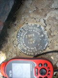
 view gallery view galleryS2.9 km | HB0451 - I24 L 3 RESET in U.S. Benchmarks A STANDARD DISK CEMENTED IN A DRILL HOLE IN THE WEST END OF THE NORTH CONCRETE HEADWALL OF A 10 X 5 FOOT CONCRETE CULVERT UNDER THE ACCESS ROAD FOR STATE ROUTE 305 ONTO INTERSTATE ROUTE 24, AND THE DISK IS STAMPED I-24 L-3 RESET 1971. posted by: trailhound1 location: Kentucky date approved: 06/30/2011 last visited: 06/29/2011 |
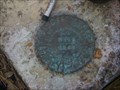
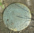 view gallery view galleryS3.1 km | HB0360 - TT 18 CAG USGS in U.S. Benchmarks A USGS survey disk set into the top of a round concrete monument posted by: trailhound1 location: Kentucky date approved: 06/30/2011 last visited: 06/29/2011 |
 view gallery view gallery SW3.4 km SW3.4 km
|  Huyck Farm Barn Quilt - Paducah, KY Huyck Farm Barn Quilt - Paducah, KY
in Painted Barn Quilts This barn quilt attracts attention of those driving by, luring them into this garden center. posted by: wildernessmama location: Kentucky date approved: 06/13/2018 last visited: never |
 view gallery view galleryS3.4 km | HB0363 - P 129 in U.S. Benchmarks A US COAST AND GEODETIC SURVEY STANDARD DISK CEMENTED IN A DRILL HOLE SET IN THE TOP OF THE NORTHEAST END OF THE SOUTHEAST CONCRETE ABUTMENT OF A HIGHWAY BRIDGE OVER PERKINS CREEK, posted by: trailhound1 location: Kentucky date approved: 07/08/2011 last visited: 06/29/2011 |
 view gallery view galleryS3.4 km |  9/11 Memorial at Noble Park, Paducah, Kentucky 9/11 Memorial at Noble Park, Paducah, Kentucky
in 9/11 Memorial Sites A small memorial at one of the entrances of Noble Park. posted by: Titansfan location: Kentucky date approved: 01/08/2008 last visited: 06/28/2011 |
 view gallery view galleryS3.4 km | HB0361 - T 389 in U.S. Benchmarks A US COAST AND GEODETIC SURVEY STANDARD DISK CEMENTED IN A DRILL HOLE SET IN THE TOP OF THE SOUTHWEST SIDE OF AN ABANDONED CONCRETE FOUNDATION WHICH PROJECTS 5 INCHES ABOVE THE LEVEL OF THE STREET. posted by: trailhound1 location: Kentucky date approved: 07/08/2011 last visited: 06/29/2011 |
 view gallery view gallerySE3.7 km | HB0357 - R129 in U.S. Benchmarks A US COAST AND GEODETIC SURVEY STANDARD DISK CEMENTED IN A DRILL HOLE SET IN THE TOP OF SOUTHEAST CORNER OF THE MOST EASTERLY OF FOUR ABANDONED CONCRETE FOOTINGS posted by: trailhound1 location: Kentucky date approved: 07/08/2011 last visited: 06/29/2011 |
 view gallery view galleryS3.7 km | West Kentucky Industrial College - Paducah, Kentucky in Kentucky Historical Markers Historical marker for an African-American college in Paducah, Kentucky posted by: BruceS location: Kentucky date approved: 05/13/2009 last visited: 04/06/2014 |
 view gallery view galleryS3.7 km |  Paducah McCracken County Senior Citizens Center - Paducah, Kentucky Paducah McCracken County Senior Citizens Center - Paducah, Kentucky
in Municipal Community Centers Senior citizens center in Paducah, Kentucky. posted by: BruceS location: Kentucky date approved: 05/13/2009 last visited: 06/28/2011 |
|