 view gallery view gallery NW0.2 km NW0.2 km
|   Adairville Utah Adairville Utah
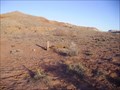
in Ghost Towns This ghost is on the Paria (Pahreah) River, north of where US 89 crosses the river, 42 miles east of Kanab. Founded by Thomas Adair and a group of farmers in 1872. It was abandoned by the 1920s. Not much remains. posted by:  caverspencer caverspencer location: Utah date approved: 02/16/2007 last visited: never |
 view gallery view galleryNW0.3 km |  Adairville Adairville
in Abandoned Cemeteries Burial site at the old ghost town of Adairville Utah posted by: caverspencer location: Utah date approved: 02/16/2007 last visited: never |
 view gallery view gallery S0.8 km S0.8 km
|  Western Rock Products - Paria Quarry Western Rock Products - Paria Quarry
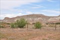
in Active Quarries This Active Quarry is located on the north side of US Highway 89 approximately 42 miles east of Kanab, Utah. posted by:  brwhiz brwhiz location: Utah date approved: 05/06/2013 last visited: 05/15/2015 |
 view gallery view gallery SE1.8 km SE1.8 km
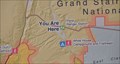
|  Paria Ranger Station Paria Ranger Station
in 'You Are Here' Maps You Are Here at the Paria Ranger Station on US Highway 89 in Grand Staircase-Escalante National Monument. posted by: brwhiz location: Utah date approved: 06/15/2011 last visited: 02/13/2014 |
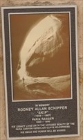 view gallery view gallerySE1.9 km |  Rodney Allan Schipper Rodney Allan Schipper
in Citizen Memorials This Citizen Memorial is mounted on a sandstone slab in front of the Paria Ranger Station of the Grand Staircase-Escalante National Monument, located on the south side of US Highway 89 about 42 miles (by highway) east of Kanab, Utah. posted by: brwhiz location: Utah date approved: 05/05/2013 last visited: never |
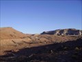
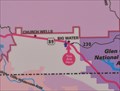
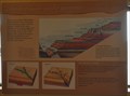 view gallery view gallerySE1.9 km |  Colorado Plateau - Grand Staircase Colorado Plateau - Grand Staircase
in Places of Geologic Significance The Grand Staircase of the Colorado Plateau starts at the Grand Canyon and proceeds northward and upward 6,000 feet in a series of steps to the Pink Cliffs above Bryce Canyon. posted by: brwhiz location: Utah date approved: 05/06/2013 last visited: never |
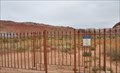
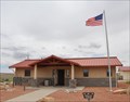 view gallery view gallerySE1.9 km |  Grand Staircase-Escalante National Monument: Paria Contact Station Grand Staircase-Escalante National Monument: Paria Contact Station
in Ranger Stations This Ranger Station is located on the south side of US Highway 89 about 42 miles (by highway) east of Kanab, Utah. posted by: brwhiz location: Utah date approved: 05/06/2013 last visited: 10/09/2005 |
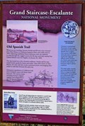 view gallery view galleryNW10.5 km |  Grand Staircase - Escalante National Monument - Kane County, UT Grand Staircase - Escalante National Monument - Kane County, UT
in Utah Historical Markers This marker commemorates the history of the Old Spanish Trail through southern Utah. posted by: rjmcdonough1 location: Utah date approved: 10/12/2019 last visited: never |
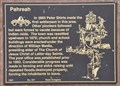
 view gallery view galleryNW10.5 km |  First Settlement in Pahreah Area First Settlement in Pahreah Area
in First of its Kind Peter Shirts made the first settlement in the Pahreah area in 1865. posted by: brwhiz location: Utah date approved: 10/13/2012 last visited: 08/23/2019 |
 view gallery view galleryNW10.5 km | Pahreah in Utah Historical Markers This Historical Marker is located on the north side of US Highway 89 about 33 miles east of Kanab or 23 miles west of Big Water. posted by: brwhiz location: Utah date approved: 10/14/2012 last visited: 03/07/2015 |
 view gallery view galleryNW10.5 km |  Pahreah ~ 347 Pahreah ~ 347
in D.U.P. Historic Markers This Daughters of Utah Pioneers Historical Marker is located on the north side of US Highway 89 about 33 miles east of Kanab or 23 miles west of Big Water. posted by: brwhiz location: Utah date approved: 10/17/2012 last visited: 08/23/2019 |
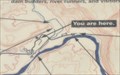
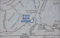 view gallery view galleryNW10.5 km | Paria (Pahreah) Access Road in 'You Are Here' Maps You Are Here on US Highway 89 at the start of the gravel access road to the Paria Movie Set and Pahreah Ghost Town site. posted by: brwhiz location: Utah date approved: 06/15/2011 last visited: 03/07/2015 |
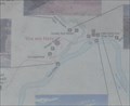
 view gallery view gallery N14 km N14 km
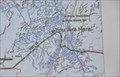
| Paria Movie Set in 'You Are Here' Maps You Are Here in the vicinity of the Paria Movie Set and a short distance away from the site of Pahreah on the opposite side of the river. posted by: brwhiz location: Utah date approved: 06/15/2011 last visited: never |
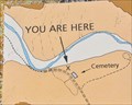
 view gallery view galleryN14.5 km |  Paria Cemetery Paria Cemetery
in Worldwide Cemeteries This Cemetery is located about 5 miles north of US Highway 89, about 40 miles east of Kanab, Utah. posted by: brwhiz location: Utah date approved: 05/10/2013 last visited: never |
 view gallery view galleryN15 km | Pariah (Pahreah), Utah in Ghost Towns Pariah (also called Pahreah) consists of a small abandoned town and cemetery, which has been used as a movie set, located in remote southern Utah. The movie set includes several new buildings, which can fool visitors into thinking they're visiting the town itself. Pariah was actually located across a nearby river, and the cemetery lies between the set and the town. posted by: DavidMac location: Utah date approved: 02/09/2006 last visited: 05/22/2011 |
 view gallery view gallery E22.7 km E22.7 km
| Big Water Visitor Center ~ Grand Staircase-Escalante National Monument in 'You Are Here' Maps You Are Here at the Big Water Visitor Center for the Grand Staircase-Escalante National Monument on US Highway 89 at Ethan Allen in Big Water, Utah. posted by: brwhiz location: Utah date approved: 10/12/2012 last visited: 02/12/2014 |
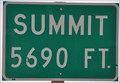 view gallery view gallery W23.3 km W23.3 km
|  Kanab East Summit ~ Elevation 5690 Kanab East Summit ~ Elevation 5690
in Elevation Signs This summit is east of Kanab on US Highway 89. posted by: brwhiz location: Utah date approved: 06/15/2011 last visited: never |
 view gallery view gallerySE32.8 km |  Welcome to Utah Welcome to Utah
in Welcome Signs Welcome to Utah ~ "Life Elevated" posted by: brwhiz location: Utah date approved: 06/17/2011 last visited: 11/15/2018 |
 view gallery view gallerySE33 km |  AZ/UT along US Highway 89 AZ/UT along US Highway 89
in Border Crossings This is the point where you cross from Arizona to Utah when traveling northwest from Page, Arizona. posted by: brwhiz location: Utah date approved: 06/18/2011 last visited: 11/15/2018 |
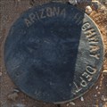 view gallery view gallerySE33 km |  ADOT ROW Marker ~ US Highway 89 - Arizona/Utah Border ADOT ROW Marker ~ US Highway 89 - Arizona/Utah Border
in U.S. Benchmarks This ADOT ROW Marker is on the west side of US Highway 89 at the Arizona/Utah Border. posted by: brwhiz location: Arizona date approved: 11/09/2012 last visited: never |
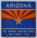 view gallery view gallerySE33 km | Welcome to Arizona in Welcome Signs Arizona ~ The "Grand Canyon State" Welcomes You posted by: brwhiz location: Arizona date approved: 06/17/2011 last visited: 06/28/2015 |
 view gallery view gallerySE39.3 km | Lonely Dell Ranch Cemetery in 'You Are Here' Maps You Are Here at the Cemetery on the upper end of the Lonely Dell Ranch Historic District near Lee's Ferry, just north of Lee's Ferry Road about 4.5 miles from US Highway 89A at Marble Canyon, Arizona. posted by: brwhiz location: Arizona date approved: 11/21/2012 last visited: never |
 view gallery view gallerySE39.4 km | Lee's Ferry Ranger Station #1 in 'You Are Here' Maps You Are Here at the Lee's Ferry Ranger Station for the Glen Canyon National Recreation Area on Lee's Ferry Road about 4.7 miles from US Highway 89A at Marble Canyon, Arizona. posted by: brwhiz location: Arizona date approved: 11/21/2012 last visited: never |
 view gallery view gallerySE39.4 km | Lee's Ferry Ranger Station #2 in 'You Are Here' Maps You Are Here at the Lee's Ferry Ranger Station for the Glen Canyon National Recreation Area on Lee's Ferry Road about 4.7 miles from US Highway 89A at Marble Canyon, Arizona. posted by: brwhiz location: Arizona date approved: 11/21/2012 last visited: never |
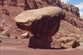 view gallery view gallerySE39.6 km |  Glen Canyon NRA Balanced Rock Glen Canyon NRA Balanced Rock
in Nature's Balanced Rocks A balanced rock on the south western side of the Glen Canyon National Recreation Area. posted by: ggmorton location: Arizona date approved: 10/03/2007 last visited: 08/01/2014 |
|