 view gallery view gallery N6.3 km N6.3 km
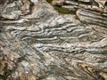
|   The Dinkey Creek Roof Pendant The Dinkey Creek Roof Pendant
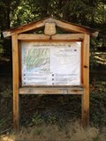
in Places of Geologic Significance The Dinkey Creek Roof Pendant is described as the remnant of a layer of meta-sediments that were above the Dinkey Creek Pluton that intruded underneath them. These rocks have been folded three different ways. posted by:  TerryDad2 TerryDad2 location: California date approved: 01/02/2010 last visited: never |
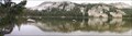 view gallery view galleryN7.4 km | South Lake – A Cirque in Places of Geologic Significance The geomorphology of The Dinkey Lakes region has been largely created by the various glaciers that have covered the area. One of the landforms that the glaciers creates is a cirque. And when the cirque fills in with water it forms a tarn. posted by: TerryDad2 location: California date approved: 01/03/2010 last visited: never |
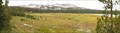 view gallery view galleryN7.9 km | First Dinkey Lake Eutrophication in Places of Geologic Significance First Dinkey Lake is a dieing lake. From the moment of its creation sediment has been slowly filling it in and it will one day become a meadow. This process is called eutrophication. posted by: TerryDad2 location: California date approved: 01/03/2010 last visited: never |
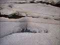 view gallery view galleryN8.4 km | Dinky Creek Pluton in Places of Geologic Significance Recent theories of large granite futon formation start with the partial melting of a subducting plate. This magma rises up through fractures near the surface where the magma spreads out laterally along a horizontal fracture. posted by: TerryDad2 location: California date approved: 01/02/2010 last visited: never |
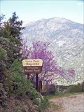
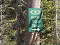 view gallery view galleryN16.3 km |  Indian Pools Trail Indian Pools Trail
in Hiking and walking trailheads A short hike to a beautiful swimming hole. posted by: toponym location: California date approved: 07/18/2010 last visited: never |
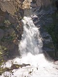
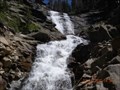 view gallery view galleryN17.7 km |  Rancheria Falls Rancheria Falls
in Waterfalls Cascade falls at the end of a short trail. posted by: toponym location: California date approved: 07/25/2010 last visited: 04/06/2010 |
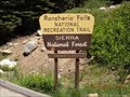 view gallery view galleryN17.7 km | Rancheria Falls National Recreation Trail in Hiking and walking trailheads A short trail to waterfalls. posted by: toponym location: California date approved: 07/20/2010 last visited: never |
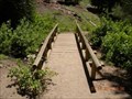 view gallery view galleryN17.7 km |  Rancheria Falls Trail foot bridge Rancheria Falls Trail foot bridge
in Hiking Path Footbridges A short bridge over a small creek on a short trail. posted by: toponym location: California date approved: 07/17/2010 last visited: never |
 view gallery view galleryN19.5 km | Deer Creek Trailhead in Hiking and walking trailheads Located at the DF Pack Station, Deer Creek Road, Lakeshore, CA posted by: fresgo location: California date approved: 07/14/2013 last visited: never |
 view gallery view galleryN23.5 km |  Kaiser Peak Kaiser Peak
in Mountain Summits Kaiser Wilderness posted by: fresgo location: California date approved: 07/16/2013 last visited: never |
 view gallery view gallery S25.3 km S25.3 km
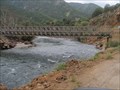
|  Kings River Crossing Kings River Crossing
in Bailey Bridges Baily's Bridge crossing the Kings River posted by: kingsrafter location: California date approved: 07/01/2011 last visited: 05/06/2011 |
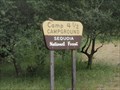 view gallery view galleryS26.1 km |  Camp 4 1/2 (Crazy Horse) Camp 4 1/2 (Crazy Horse)
in Campgrounds Perfect Cabin the Kings River. All you need to bring is Food and Linens. posted by: kingsrafter location: California date approved: 07/06/2011 last visited: 05/06/2011 |
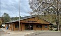
 view gallery view gallery W28.6 km W28.6 km
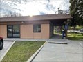
|  Tollhouse, CA - 93667 Tollhouse, CA - 93667
in U.S. Post Offices A post office in Tollhouse, CA. posted by: saopaulo1 location: California date approved: 03/02/2022 last visited: never |
 view gallery view galleryW32.5 km |  True Center of California True Center of California
in U.S. Benchmarks Center of California as determined by CSU Fresno posted by: Clan_Armstrong location: California date approved: 03/09/2014 last visited: 07/30/2020 |
 view gallery view gallery SE32.8 km SE32.8 km
|  Boole Tree Boole Tree
in Exceptional Trees The Boole Tree, eighth largest tree in the world posted by: Daniel Nestlerode location: California date approved: 07/07/2008 last visited: 02/20/2018 |
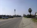 view gallery view galleryS33.3 km |  Biola Tank Biola Tank
in Water Towers 12814 W. “G” Street, (4th and G Streets) in Downtown Biola, California posted by: fresgo location: California date approved: 02/06/2009 last visited: 02/06/2010 |
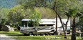 view gallery view gallery SW34.4 km SW34.4 km
| Lakeridge Camping & Boating Resort in Campgrounds Lakeridge Camping & Boating resort is near Pine Flat Lake Marina. 107 total spaces offer overnight camping and extended stays. Fishing, Boating, Water Sports, Hiking and other outdoor activities are here. Half way between Yosemite & Sequoia NP. posted by:  gdubu gdubu location: California date approved: 06/14/2009 last visited: never |
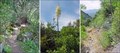
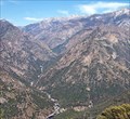 view gallery view gallerySE34.6 km |  Junction View, Kings Canyon, CA Junction View, Kings Canyon, CA
in Scenic Roadside Look-Outs The best place to see Kings Canyon posted by: Bernd das Brot Team location: California date approved: 05/20/2008 last visited: 07/28/2013 |
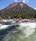 view gallery view gallerySE34.8 km |  CONFLUENCE - Kings River South and Middle Fork CONFLUENCE - Kings River South and Middle Fork
in River Origins, Destinations and Confluences Junction of the two main forks of California's Kings River posted by: Bernd das Brot Team location: California date approved: 04/27/2008 last visited: never |
 view gallery view galleryW34.9 km | Auberry, CA - 93602 in U.S. Post Offices The post office in Auberry, CA. posted by: saopaulo1 location: California date approved: 03/02/2022 last visited: never |
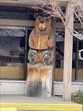 view gallery view galleryW34.9 km |  Library Bear - Auberry, CA Library Bear - Auberry, CA
in Bear Statues A bear in front of the Auberry library. posted by: saopaulo1 location: California date approved: 02/16/2022 last visited: never |
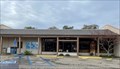 view gallery view galleryW34.9 km |  Auberry Library - Auberry, CA Auberry Library - Auberry, CA
in Libraries The Auberry library in Fresno County. posted by: saopaulo1 location: California date approved: 02/14/2022 last visited: never |
 view gallery view gallerySE34.9 km | Tenmile Creek Cascades in Waterfalls A short, cascading river in Kings Canyon posted by: Bernd das Brot Team location: California date approved: 05/17/2008 last visited: never |
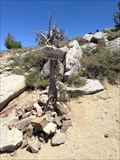
 view gallery view gallerySE35.2 km |  Yucca Point Trail, Kings Canyon, California Yucca Point Trail, Kings Canyon, California
in Trail Registers The trail leads from hwy 180 down to the Kings River. posted by: Bernd das Brot Team location: California date approved: 05/24/2006 last visited: 02/02/2019 |
 view gallery view gallerySE35.2 km |  Yucca Point Trail, Kings Canyon, CA Yucca Point Trail, Kings Canyon, CA
in Scenic Hikes A steep trail from Kings Canyon Road down to Kings River posted by: Bernd das Brot Team location: California date approved: 05/19/2008 last visited: never |
|