 view gallery view gallery NW2.7 km NW2.7 km
|   Fort Huger - Smithfield VA Fort Huger - Smithfield VA
in Civil Rights Memorials Beginning in July 1861, enslaved and freed blacks assisted in the construction of Fort Huger. posted by:  Don.Morfe Don.Morfe location: Virginia date approved: 08/24/2023 last visited: 08/25/2023 |
 view gallery view galleryNW2.7 km |  Fort Huger - Smithfield VA Fort Huger - Smithfield VA
in American Civil War Monuments and Memorials Fort Huger marker is on Fort Huger Drive (Virginia Route 676), Smithfield VA 23430 in Isle of Wight County. Marker Number: K-327. posted by: Don.Morfe location: Virginia date approved: 09/06/2023 last visited: 09/06/2023 |
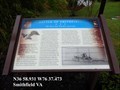
 view gallery view galleryNW2.7 km |  Fort Huger Fort Huger
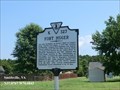
in Virginia Historical Markers One mile northeast, at Hardy’s Bluff on Lawne’s Neck, existed Fort Huger, a Civil War earthen fortification. posted by: Don.Morfe location: Virginia date approved: 03/16/2020 last visited: 10/20/2021 |
 view gallery view gallery SE5.5 km SE5.5 km
|  Residential Lion, Smithfield, VA Residential Lion, Smithfield, VA
in Lion Statues A simple lion in front of a residence in Smithfield, VA. posted by:  Team Roberson Team Roberson location: Virginia date approved: 01/02/2006 last visited: 01/02/2008 |
 view gallery view gallery N6.3 km N6.3 km
|  Battle at Fort Huger - Smithfield VA Battle at Fort Huger - Smithfield VA
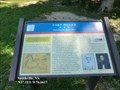
in Battlefields Union Cmdr. John Rodgers led a gunboat squadron up the James River on May 8, 1862. USS Galena, USS Aroostook, and USS Port Royal steamed toward Fort Huger and attacked at 11:20 A.M. Aroostook and Port Royal took position and shelled the bluffs. posted by: Don.Morfe location: Virginia date approved: 11/21/2020 last visited: 10/16/2021 |
 view gallery view galleryN6.3 km | Fort Huger-Defending the James River - Smithfield VA in U.S. Civil War Sites Slaves and free blacks constructed the fort under direction of the Confederate Engineer Bureau, and detachments of Lt. Col. Fletcher Archer’s 5th Virginia infantry Battalion were posted here. posted by: Don.Morfe location: Virginia date approved: 06/27/2023 last visited: 06/27/2023 |
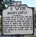 view gallery view galleryNW7.7 km | Bacon's Castle in Virginia Historical Markers Bacon's Castle was a home built in 1655. During Bacon's Rebellion in 1676 it was seized by the rebels. posted by: VirginiaSeeker location: Virginia date approved: 08/07/2006 last visited: 11/20/2010 |
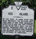 view gallery view galleryNW7.9 km | Hog Island in Virginia Historical Markers Hog Island was the place Jamestown settlers kept their hogs in 1608. posted by: VirginiaSeeker location: Virginia date approved: 08/07/2006 last visited: 05/09/2009 |
 view gallery view gallery S8.9 km S8.9 km
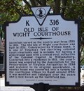
| Old Isle of Wight Courthouse in Virginia Historical Markers The Old Isle of Wight Courthouse was built in 1752 and is one of Virginia's few surviving court buildings. posted by: VirginiaSeeker location: Virginia date approved: 08/07/2006 last visited: 04/04/2016 |
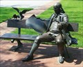 view gallery view galleryS8.9 km |  Ben Franklin Statue/bench - Smithfield, Va Ben Franklin Statue/bench - Smithfield, Va
in Benjamin Franklin A sit-by-me statue of Ben Franklin in downtown Smithfield, Va.
posted by: Big B Bob location: Virginia date approved: 11/07/2009 last visited: 01/01/2014 |
 view gallery view galleryS8.9 km |  Franklin Crater - Ben Franklin Statue Franklin Crater - Ben Franklin Statue
in Extraterrestrial Locations A sit-by-me statue of Ben Franklin in downtown Smithfield, Va. posted by: fatcat161 location: Virginia date approved: 07/09/2009 last visited: 01/01/2014 |
 view gallery view galleryS8.9 km |  Smithfield Va Sidewalks Smithfield Va Sidewalks
in Donated Engraved Bricks and Pavers The sidewalks on Main St in Smithfield Va are paved with bricks, many denoted/dedicated.
posted by: fatcat161 location: Virginia date approved: 04/27/2009 last visited: never |
 view gallery view galleryS8.9 km |  H. Woodrow Crook H. Woodrow Crook
in Unintentionally Funny Signs H. Woodrow Crook - Attorney at Law posted by: fatcat161 location: Virginia date approved: 05/02/2009 last visited: never |
 view gallery view gallerySE9 km | Battle of Smithfield - Smithfield VA in Battlefields The troops marched inland, skirmished with local Confederates, then returned to Smith?eld, only to ?nd that the Smith-Briggs had not returned to retrieve them. The next day, February 1, 1864, the Confederates disputed the Union retreat. posted by: Don.Morfe location: Virginia date approved: 11/21/2020 last visited: 10/16/2021 |
 view gallery view gallerySE9 km | Battle of Smithfield-The Town that Wouldn’t Surrender - Smithfield VA in U.S. Civil War Sites This section of the Pagan River in front of you is where the Union gunboat, USS Smith-Briggs, was run aground and destroyed by local Confederate troops during the January 31-February 1, 1864, Battle of Smith?eld. posted by: Don.Morfe location: Virginia date approved: 06/27/2023 last visited: 06/27/2023 |
 view gallery view gallerySE9 km | Battle of Smithfield-The Town that Wouldn’t Surrender - Smithfield VA in Civil War Discovery Trail Sites This section of the Pagan River in front of you is where the Union gunboat, USS Smith-Briggs, was run aground and destroyed by local Confederate troops during the January 31-February 1, 1864, Battle of Smith?eld. posted by: Don.Morfe location: Virginia date approved: 07/23/2020 last visited: 10/05/2021 |
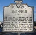 view gallery view gallerySE9 km | Smithfield in Virginia Historical Markers Smithfield is famous for hams and peanuts. posted by: VirginiaSeeker location: Virginia date approved: 03/03/2007 last visited: 02/20/2023 |
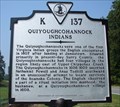 view gallery view galleryNW9.3 km | Quiyoughcohannock Indians in Virginia Historical Markers The Quiyoughcohannock were one of the first Virginia Indians the English settlers encountered. posted by: VirginiaSeeker location: Virginia date approved: 09/10/2006 last visited: never |
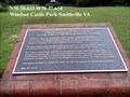 view gallery view gallerySE9.5 km |  Joseph W. Luter, III - Smithfield VA Joseph W. Luter, III - Smithfield VA
in Citizen Memorials Joseph W. Luter, III, CEO Smithfield Foods, donated Windsor Castle Park to the town of Smithfield on May 22, 2010. The park has walking trails,
kayak launch, dog park, fishing pier and pedestrian bridges. posted by: Don.Morfe location: Virginia date approved: 02/20/2023 last visited: 02/20/2023 |
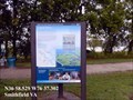 view gallery view gallerySE9.8 km |  Liquid Maze Captain John Smith Chesapeake National Historic Trail - Smithfield, VA Liquid Maze Captain John Smith Chesapeake National Historic Trail - Smithfield, VA
in Signs of History More than 100,000 rivers, streams, and creeks flow through the Chesapeake region. This massive web of waterways includes some 11,000 miles of shoreline---more than that of the entire U.S. West Coast. posted by: Don.Morfe location: Virginia date approved: 01/22/2020 last visited: 09/25/2021 |
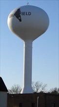 view gallery view gallerySE11.6 km |  Smithfield, VA Water Tower Smithfield, VA Water Tower
in Water Towers Smithfield Water Tower is one of several serving the town and local businesses. posted by: VirginiaSeeker location: Virginia date approved: 03/03/2007 last visited: 12/26/2013 |
 view gallery view galleryNW11.9 km | Working the Land Captain John Smith Chesapeake National Historic Trail - Surry, VA in Signs of History Indians cultivated fertile lands along the James River for centuries before the colonists arrived in 1607. They grew squash, corn, and beans to supplement their diet of native plants, fish, shellfish, and game. posted by: Don.Morfe location: Virginia date approved: 01/22/2020 last visited: 09/25/2021 |
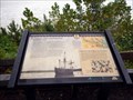 view gallery view galleryNW11.9 km | Captain John Smith’s Adventures on the James -Surry, VA in Signs of History Captain John Smith’s Adventures on the James-Chippokes Plantation State Park— James River beach —Prior to unloading at Jamestown, the English sailed the James in search of a suitable location. In his account, George Perch recalls crossing to the southern shore on May 5, 1607 at the invitation of a chief he misidentifies as the "Werowance of Rapahanna." posted by: Don.Morfe location: Virginia date approved: 01/22/2020 last visited: 09/25/2021 |
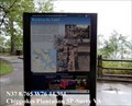
 view gallery view galleryNW11.9 km |  Chippokes State Park - Surry VA Chippokes State Park - Surry VA
in Wikipedia Entries Chippokes State Park (previously known as Chippokes Plantation State Park) is located at 695 Chippokes Park Road, Surry VA 23883 posted by: Don.Morfe location: Virginia date approved: 09/26/2023 last visited: 09/26/2023 |
 view gallery view galleryNW11.9 km | Working the Land Captain John Smith Chesapeake National Historic Trail - Surry, VA in Civil Rights Memorials Indians cultivated fertile lands along the James River for centuries before the colonists arrived in 1607. They grew squash, corn, and beans to supplement their diet of native plants, fish, shellfish, and game. posted by: Don.Morfe location: Virginia date approved: 09/27/2023 last visited: 09/27/2023 |
|