 view gallery view gallery NE7.7 km NE7.7 km
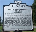
|   Quiyoughcohannock Indians Quiyoughcohannock Indians
in Virginia Historical Markers The Quiyoughcohannock were one of the first Virginia Indians the English settlers encountered. posted by:  VirginiaSeeker VirginiaSeeker location: Virginia date approved: 09/10/2006 last visited: never |
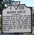 view gallery view galleryNE7.9 km | Bacon's Castle in Virginia Historical Markers Bacon's Castle was a home built in 1655. During Bacon's Rebellion in 1676 it was seized by the rebels. posted by: VirginiaSeeker location: Virginia date approved: 08/07/2006 last visited: 11/20/2010 |
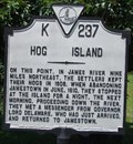 view gallery view galleryNE8 km | Hog Island in Virginia Historical Markers Hog Island was the place Jamestown settlers kept their hogs in 1608. posted by: VirginiaSeeker location: Virginia date approved: 08/07/2006 last visited: 05/09/2009 |
 view gallery view gallery N9.2 km N9.2 km
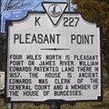
| Pleasant Point in Virginia Historical Markers Pleasant Point is located on the James River. posted by: VirginiaSeeker location: Virginia date approved: 01/29/2007 last visited: never |
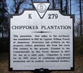 view gallery view galleryN9.2 km | Chippokes Plantation in Virginia Historical Markers Chippokes Plantation is now a state park dedicated to depicting life during the colonial period. posted by: VirginiaSeeker location: Virginia date approved: 01/29/2007 last visited: 11/20/2010 |
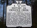 view gallery view galleryN9.2 km | History on Crouch's Creek in Virginia Historical Markers Crouch's Creek was originally called Tappahannock Creek. posted by: VirginiaSeeker location: Virginia date approved: 01/29/2007 last visited: never |
 view gallery view gallery E9.5 km E9.5 km
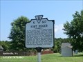
| Fort Huger in Virginia Historical Markers One mile northeast, at Hardy’s Bluff on Lawne’s Neck, existed Fort Huger, a Civil War earthen fortification. posted by:  Don.Morfe Don.Morfe location: Virginia date approved: 03/16/2020 last visited: 10/20/2021 |
 view gallery view galleryE9.5 km |  Fort Huger - Smithfield VA Fort Huger - Smithfield VA
in Civil Rights Memorials Beginning in July 1861, enslaved and freed blacks assisted in the construction of Fort Huger. posted by: Don.Morfe location: Virginia date approved: 08/24/2023 last visited: 08/25/2023 |
 view gallery view galleryE9.5 km |  Fort Huger - Smithfield VA Fort Huger - Smithfield VA
in American Civil War Monuments and Memorials Fort Huger marker is on Fort Huger Drive (Virginia Route 676), Smithfield VA 23430 in Isle of Wight County. Marker Number: K-327. posted by: Don.Morfe location: Virginia date approved: 09/06/2023 last visited: 09/06/2023 |
 view gallery view gallery NW10.6 km NW10.6 km
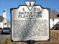
| Smith's Fort Plantation in Virginia Historical Markers Smith's Fort was on the opposite side of the James River from Jamestown. posted by: VirginiaSeeker location: Virginia date approved: 01/28/2007 last visited: 03/21/2013 |
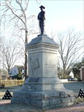 view gallery view galleryNW10.8 km | Confederate Soldier Memorial of Surry County in American Civil War Monuments and Memorials A granite and Bronze Memorial to Confederate Soldiers from Surry County, Virginia posted by: AZkayaker location: Virginia date approved: 02/14/2009 last visited: 03/21/2013 |
 view gallery view galleryN11.6 km |  Working the Land Captain John Smith Chesapeake National Historic Trail - Surry, VA Working the Land Captain John Smith Chesapeake National Historic Trail - Surry, VA
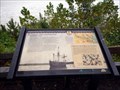
in Signs of History Indians cultivated fertile lands along the James River for centuries before the colonists arrived in 1607. They grew squash, corn, and beans to supplement their diet of native plants, fish, shellfish, and game. posted by: Don.Morfe location: Virginia date approved: 01/22/2020 last visited: 09/25/2021 |
 view gallery view galleryN11.6 km | Captain John Smith’s Adventures on the James -Surry, VA in Signs of History Captain John Smith’s Adventures on the James-Chippokes Plantation State Park— James River beach —Prior to unloading at Jamestown, the English sailed the James in search of a suitable location. In his account, George Perch recalls crossing to the southern shore on May 5, 1607 at the invitation of a chief he misidentifies as the "Werowance of Rapahanna." posted by: Don.Morfe location: Virginia date approved: 01/22/2020 last visited: 09/25/2021 |
 view gallery view galleryN11.6 km |  Chippokes State Park - Surry VA Chippokes State Park - Surry VA
in Official Local Tourism Attractions Chippokes State Park (previously known as Chippokes Plantation State Park) is located at 695 Chippokes Park Road, Surry VA 23883 posted by: Don.Morfe location: Virginia date approved: 09/26/2023 last visited: 09/26/2023 |
 view gallery view galleryN11.6 km |  Coin-Operated Binoculars at Chippokes State Park - Surry VA Coin-Operated Binoculars at Chippokes State Park - Surry VA
in Coin-Op Binoculars The Coin-Operated Binocular at Chippokes State Park is at the water's edge. Chippokes State Park (previously known as Chippokes Plantation State Park) is located at 695 Chippokes Park Road, Surry VA 23883 posted by: Don.Morfe location: Virginia date approved: 09/27/2023 last visited: 09/27/2023 |
 view gallery view galleryN11.6 km |  Chippokes State Park - Surry VA Chippokes State Park - Surry VA
in State/Provincial Parks Chippokes State Park (previously known as Chippokes Plantation State Park) is located at 695 Chippokes Park Road, Surry VA 23883 posted by: Don.Morfe location: Virginia date approved: 09/27/2023 last visited: 09/27/2023 |
 view gallery view galleryN11.6 km | Working the Land Captain John Smith Chesapeake National Historic Trail - Surry, VA in Civil Rights Memorials Indians cultivated fertile lands along the James River for centuries before the colonists arrived in 1607. They grew squash, corn, and beans to supplement their diet of native plants, fish, shellfish, and game. posted by: Don.Morfe location: Virginia date approved: 09/27/2023 last visited: 09/27/2023 |
 view gallery view galleryN11.6 km |  Chippokes State Park - Surry VA Chippokes State Park - Surry VA
in Wikipedia Entries Chippokes State Park (previously known as Chippokes Plantation State Park) is located at 695 Chippokes Park Road, Surry VA 23883 posted by: Don.Morfe location: Virginia date approved: 09/26/2023 last visited: 09/26/2023 |
 view gallery view galleryN11.6 km |  'You Are Here' Maps-Chippokes State Park - Surry VA 'You Are Here' Maps-Chippokes State Park - Surry VA
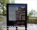
in 'You Are Here' Maps The 'You Are Here' Map shows that you are at Chippokes State Park (previously known as Chippokes Plantation State Park) is located at 695 Chippokes Park Road, Surry VA 23883 posted by: Don.Morfe location: Virginia date approved: 09/26/2023 last visited: 09/26/2023 |
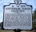 view gallery view galleryNW12.9 km | Southwark Parish Churches in Virginia Historical Markers Southwark Parish was a colonial church in Surry County. posted by: VirginiaSeeker location: Virginia date approved: 01/30/2007 last visited: 05/09/2009 |
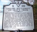 view gallery view galleryNW12.9 km | English Settlement on Gray's Creek in Virginia Historical Markers Early settlements were part of the defense of Jamestown across the river. posted by: VirginiaSeeker location: Virginia date approved: 01/30/2007 last visited: never |
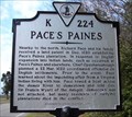 view gallery view galleryNW12.9 km | Pace's Paines in Virginia Historical Markers Richard Pace rowed across the James River to Jamestown to warn of a possible attack. posted by: VirginiaSeeker location: Virginia date approved: 01/30/2007 last visited: never |
 view gallery view galleryNE13 km |  Battle at Fort Huger - Smithfield VA Battle at Fort Huger - Smithfield VA
in Battlefields Union Cmdr. John Rodgers led a gunboat squadron up the James River on May 8, 1862. USS Galena, USS Aroostook, and USS Port Royal steamed toward Fort Huger and attacked at 11:20 A.M. Aroostook and Port Royal took position and shelled the bluffs. posted by: Don.Morfe location: Virginia date approved: 11/21/2020 last visited: 10/16/2021 |
 view gallery view galleryNE13 km | Fort Huger-Defending the James River - Smithfield VA in U.S. Civil War Sites Slaves and free blacks constructed the fort under direction of the Confederate Engineer Bureau, and detachments of Lt. Col. Fletcher Archer’s 5th Virginia infantry Battalion were posted here. posted by: Don.Morfe location: Virginia date approved: 06/27/2023 last visited: 06/27/2023 |
 view gallery view galleryE14.3 km |  Residential Lion, Smithfield, VA Residential Lion, Smithfield, VA
in Lion Statues A simple lion in front of a residence in Smithfield, VA. posted by: Team Roberson location: Virginia date approved: 01/02/2006 last visited: 01/02/2008 |
|