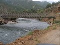
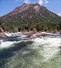
 view gallery view gallery SW17.9 km SW17.9 km
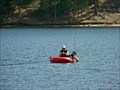
|   Kings River Crossing Kings River Crossing
in Bailey Bridges Baily's Bridge crossing the Kings River posted by:  kingsrafter kingsrafter location: California date approved: 07/01/2011 last visited: 05/06/2011 |
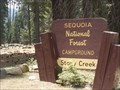
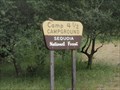 view gallery view gallerySW18.2 km |  Camp 4 1/2 (Crazy Horse) Camp 4 1/2 (Crazy Horse)
in Campgrounds Perfect Cabin the Kings River. All you need to bring is Food and Linens. posted by: kingsrafter location: California date approved: 07/06/2011 last visited: 05/06/2011 |
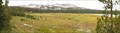
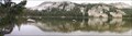 view gallery view gallery N18.2 km N18.2 km
|  South Lake – A Cirque South Lake – A Cirque
in Places of Geologic Significance The geomorphology of The Dinkey Lakes region has been largely created by the various glaciers that have covered the area. One of the landforms that the glaciers creates is a cirque. And when the cirque fills in with water it forms a tarn. posted by: TerryDad2 location: California date approved: 01/03/2010 last visited: never |
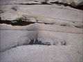
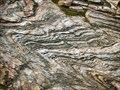 view gallery view gallery NW18.5 km NW18.5 km
| The Dinkey Creek Roof Pendant in Places of Geologic Significance The Dinkey Creek Roof Pendant is described as the remnant of a layer of meta-sediments that were above the Dinkey Creek Pluton that intruded underneath them. These rocks have been folded three different ways. posted by: TerryDad2 location: California date approved: 01/02/2010 last visited: never |
 view gallery view galleryN18.7 km | First Dinkey Lake Eutrophication in Places of Geologic Significance First Dinkey Lake is a dieing lake. From the moment of its creation sediment has been slowly filling it in and it will one day become a meadow. This process is called eutrophication. posted by: TerryDad2 location: California date approved: 01/03/2010 last visited: never |
 view gallery view galleryN19.5 km | Dinky Creek Pluton in Places of Geologic Significance Recent theories of large granite futon formation start with the partial melting of a subducting plate. This magma rises up through fractures near the surface where the magma spreads out laterally along a horizontal fracture. posted by: TerryDad2 location: California date approved: 01/02/2010 last visited: never |
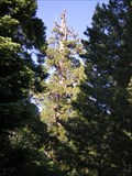 view gallery view gallery S20.4 km S20.4 km
|  Boole Tree Boole Tree
in Exceptional Trees The Boole Tree, eighth largest tree in the world posted by: Daniel Nestlerode location: California date approved: 07/07/2008 last visited: 02/20/2018 |
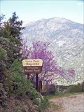
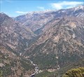 view gallery view gallery SE21.9 km SE21.9 km
|  Junction View, Kings Canyon, CA Junction View, Kings Canyon, CA
in Scenic Roadside Look-Outs The best place to see Kings Canyon posted by:  Bernd das Brot Team Bernd das Brot Team location: California date approved: 05/20/2008 last visited: 07/28/2013 |
 view gallery view gallerySE21.9 km |  CONFLUENCE - Kings River South and Middle Fork CONFLUENCE - Kings River South and Middle Fork
in River Origins, Destinations and Confluences Junction of the two main forks of California's Kings River posted by: Bernd das Brot Team location: California date approved: 04/27/2008 last visited: never |
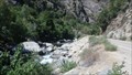
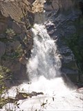 view gallery view gallerySE22 km |  Tenmile Creek Cascades Tenmile Creek Cascades
in Waterfalls A short, cascading river in Kings Canyon posted by: Bernd das Brot Team location: California date approved: 05/17/2008 last visited: never |
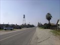 view gallery view galleryS22.2 km |  Biola Tank Biola Tank
in Water Towers 12814 W. “G” Street, (4th and G Streets) in Downtown Biola, California posted by: fresgo location: California date approved: 02/06/2009 last visited: 02/06/2010 |
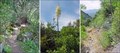 view gallery view gallerySE22.4 km |  Yucca Point Trail, Kings Canyon, California Yucca Point Trail, Kings Canyon, California
in Trail Registers The trail leads from hwy 180 down to the Kings River. posted by: Bernd das Brot Team location: California date approved: 05/24/2006 last visited: 02/02/2019 |
 view gallery view gallerySE22.5 km |  Yucca Point Trail, Kings Canyon, CA Yucca Point Trail, Kings Canyon, CA
in Scenic Hikes A steep trail from Kings Canyon Road down to Kings River posted by: Bernd das Brot Team location: California date approved: 05/19/2008 last visited: never |
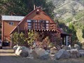 view gallery view gallerySE23.3 km |  Kings Canyon Lodge & Cabins, Kings Canyon, California Kings Canyon Lodge & Cabins, Kings Canyon, California
in Chalet, Cottage, and Cabin Style Lodging The oldest lodge in Kings Canyon posted by: Bernd das Brot Team location: California date approved: 05/18/2008 last visited: never |
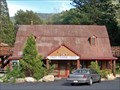 view gallery view gallerySE23.3 km | Kings Canyon Lodge, Kings Canyon, California in Lodge-Style Accommodations The oldest lodge in Kings Canyon posted by: Bernd das Brot Team location: California date approved: 05/28/2008 last visited: never |
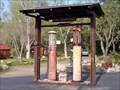 view gallery view gallerySE23.3 km |  Kings Canyon Lodge Gas Station Kings Canyon Lodge Gas Station
in Vintage Gas Stations America's oldest gravity pump posted by: Bernd das Brot Team location: California date approved: 05/19/2008 last visited: 06/21/2012 |
 view gallery view galleryS25.1 km |  Hume Lake, California Hume Lake, California
in Fishing Holes Reservoir in Kings Canyon posted by: Bernd das Brot Team location: California date approved: 05/17/2008 last visited: 09/06/2010 |
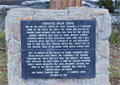 view gallery view galleryS25.3 km |  Converse Basin Grove Converse Basin Grove
in E Clampus Vitus Historical Markers E Clampus Vitus marker, commemorating a grove of Giant Sequoia trees that was cut in 1907. posted by: Bernd das Brot Team location: California date approved: 05/10/2011 last visited: never |
 view gallery view gallerySE26.9 km |  KINGS RIVER, CALIFORNIA KINGS RIVER, CALIFORNIA
in National Wild and Scenic Rivers KINGS RIVER is located in Kings Canyon National Park, CA posted by: tatie location: California date approved: 11/16/2013 last visited: 09/10/2017 |
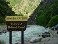 view gallery view gallerySE27 km | ") Boyden Cavern, California Boyden Cavern, California
in Cave Entrances (Natural) Cave in Kings Canyon posted by: Bernd das Brot Team location: California date approved: 04/29/2008 last visited: never |
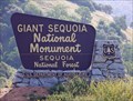 view gallery view galleryS28 km |  Giant Sequoia National Monument, California - Northern Part Giant Sequoia National Monument, California - Northern Part
in Public Access Lands Protecting the world's largest trees posted by: Bernd das Brot Team location: California date approved: 08/15/2008 last visited: 10/03/2015 |
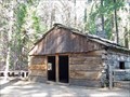 view gallery view galleryS28.3 km |  Gamlin Cabin, Kings Canyon, California Gamlin Cabin, Kings Canyon, California
in U.S. National Register of Historic Places First house in America's deepest Canyon posted by: Bernd das Brot Team location: California date approved: 05/15/2008 last visited: 03/31/2014 |
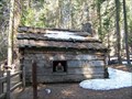 view gallery view galleryS28.3 km |  Gamlin Cabin, California Gamlin Cabin, California
in Unoccupied Buildings, Shacks, and Cabins The oldest house in Kings Canyon, built in 1872 and unoccupied since 1933. posted by: Bernd das Brot Team location: California date approved: 05/08/2010 last visited: 03/31/2014 |
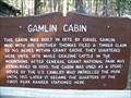 view gallery view galleryS28.3 km |  Gamlin Cabin Gamlin Cabin
in Homesteads First homestead in America's deepest canyon posted by: Bernd das Brot Team location: California date approved: 05/15/2008 last visited: 03/31/2014 |
 view gallery view galleryS28.3 km |  Sequoia National Forest - Rough Fire 2015 - CA Sequoia National Forest - Rough Fire 2015 - CA
in News Article Locations Fire started by a lightning strike July 31, 2015. 80& contained Sept.21, 2015. 80,000 + acres burned in + six weeks. posted by: sbcamper location: California date approved: 10/06/2015 last visited: 03/31/2014 |
|