 view gallery view gallery SW4.3 km SW4.3 km
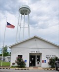
|   Wyatt Water Tower Wyatt Water Tower
in Water Towers This Water Tower is directly behind City Hall located at 215 Oak Street in Wyatt, Missouri. posted by:  brwhiz brwhiz location: Missouri date approved: 07/03/2013 last visited: never |
 view gallery view gallerySW4.3 km |  GD1556 ~ WYATT MUN TANK GD1556 ~ WYATT MUN TANK
in U.S. Benchmarks This Survey Mark is the top center of the elevated water tank located directly behind City Hall at 215 Oak Street in Wyatt, Missouri. posted by: brwhiz location: Missouri date approved: 07/05/2013 last visited: never |
 view gallery view gallerySW4.3 km |  Wyatt, Missouri Wyatt, Missouri
in City and Town Halls This City Hall is located at 215 Oak Street in Wyatt, Missouri. posted by: brwhiz location: Missouri date approved: 07/02/2013 last visited: never |
 view gallery view gallerySW4.5 km |  Wyatt, MO. 63882 Post Office Wyatt, MO. 63882 Post Office
in U.S. Post Offices 211 S. Main St.
Wyatt Mo. 63882
(573) 675-3561 posted by:  Fearless0 Fearless0 location: Missouri date approved: 02/21/2010 last visited: never |
 view gallery view gallery NE6.1 km NE6.1 km
|  Illinois/Missouri on US Highways 60&62 Illinois/Missouri on US Highways 60&62
in Border Crossings This border crossing is in the middle of the bridge that crosses the Mississippi River just above the confluence with the Ohio. The state line is marked on the bridge but you can't stop on the bridge for a picture. posted by: brwhiz location: Missouri date approved: 07/04/2013 last visited: 06/03/2021 |
 view gallery view gallery N6.9 km N6.9 km
|  Cairo, Illinois Cairo, Illinois
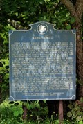
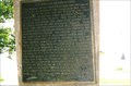
in Illinois Historical Markers This is one of two identical markers for Cairo. It is located on the south end of the parking lot at the entrance to Fort Defiance State Park, which is at the junctions of US 51 and IL 60-62. posted by: NoLemon location: Illinois date approved: 08/30/2007 last visited: 06/03/2021 |
 view gallery view galleryN7.1 km | The Beginning of the Third Principal Meridian - Historical Survey Marker - Cairo, IL in Illinois Historical Markers Located at the entrance to Fort Defiance Park posted by: nomadwillie location: Illinois date approved: 01/06/2022 last visited: 10/22/2022 |
 view gallery view galleryN7.1 km |  The Beginning of the Third Principal Meridian - Historical Survey Marker - Cairo, IL The Beginning of the Third Principal Meridian - Historical Survey Marker - Cairo, IL
in Lewis and Clark Trail Located at the entrance to Fort Defiance Park posted by: nomadwillie location: Illinois date approved: 01/06/2022 last visited: 10/22/2022 |
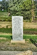
 view gallery view galleryN7.1 km |  Historical Survey Marker - Cairo, IL Historical Survey Marker - Cairo, IL
in U.S. Historic Survey Stones and Monuments Located at today's Fort Defiance State park posted by: YoSam. location: Illinois date approved: 06/27/2014 last visited: 06/03/2021 |
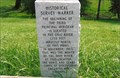 view gallery view galleryN7.1 km |  Historical Survey Marker - Cairo, IL Historical Survey Marker - Cairo, IL
in Great Lines of Earth Indicates 3rd Principal Meridian posted by: YoSam. location: Illinois date approved: 06/29/2014 last visited: 06/03/2021 |
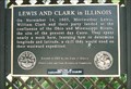 view gallery view galleryN7.1 km | Lewis and Clark in Illinois in Illinois Historical Markers At Fort Defiance, where the Captains studied, astrology, the rivers, and journal keeping, to prepare for their mission. posted by: YoSam. location: Illinois date approved: 11/05/2009 last visited: 01/06/2022 |
 view gallery view galleryN7.1 km | Lewis and Clark Corps of Discovery - Cairo, IL in Illinois Historical Markers This Lewis and Clark marker is located at the entrance of the Fort Defiance State Park in the very southern tip of Illinois. posted by: YoSam. location: Illinois date approved: 11/07/2022 last visited: never |
 view gallery view galleryN7.1 km |  Lewis and Clark Corps of Discovery - Cairo, IL Lewis and Clark Corps of Discovery - Cairo, IL
in Signs of History This Lewis and Clark marker is located at the entrance of the Fort Defiance State Park in the very southern tip of Illinois. posted by: YoSam. location: Illinois date approved: 09/19/2017 last visited: 06/03/2021 |
 view gallery view galleryN7.1 km | Lewis and Clark Corps of Discovery - Cairo, IL in Lewis and Clark Trail This Lewis and Clark marker is located at the entrance of the Fort Defiance State Park in the very southern tip of Illinois. posted by: YoSam. location: Illinois date approved: 06/26/2014 last visited: 06/03/2021 |
 view gallery view galleryN7.1 km | Lewis and Clark in Illinois - Cairo in Lewis and Clark Trail This Lewis and Clark Trail marker is located at the entrance of the Fort Defiance State Park in the very southern tip of Illinois. posted by: NoLemon location: Illinois date approved: 08/30/2007 last visited: 01/06/2022 |
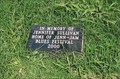 view gallery view galleryNE7.1 km |  Jennifer Dowdy Sullivan - Cairo, IL Jennifer Dowdy Sullivan - Cairo, IL
in Citizen Memorials Musical festival started here has moved on, but this marker holds on to the past. posted by: YoSam. location: Illinois date approved: 06/26/2014 last visited: never |
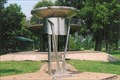
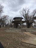 view gallery view galleryNE7.1 km |  Defiance Park Lookout, Cairo ,Illinois Defiance Park Lookout, Cairo ,Illinois
in Look-Out Towers Two levels to look over the Mississippi and Ohio Rivers. posted by: BONSAIRAD location: Illinois date approved: 12/04/2020 last visited: 06/03/2021 |
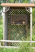
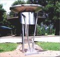 view gallery view galleryNE7.1 km |  Proceeding On - Fort Defiance, Cairo, IL Proceeding On - Fort Defiance, Cairo, IL
in Abstract Public Sculptures Installed to commemorate Lewis & Clark's Activities at Fort Defiance. posted by: YoSam. location: Illinois date approved: 09/13/2008 last visited: 06/03/2021 |
 view gallery view galleryNE7.1 km | Lewis & Clark at Fort Defiance, Cairo, IL in Lewis and Clark Trail Original piece of art to mark the activities of Lewis & Clark. posted by: YoSam. location: Illinois date approved: 09/14/2008 last visited: 06/03/2021 |
 view gallery view galleryNE7.1 km |  CONFLUENCE- Ohio River - Mississippi River CONFLUENCE- Ohio River - Mississippi River
in River Origins, Destinations and Confluences The Ohio-Mississippi Confluence has been a strategic location through out history. posted by: 8Nuts MotherGoose location: Illinois date approved: 01/03/2007 last visited: 01/06/2022 |
 view gallery view galleryNE7.1 km |  Ohio - Mississippi Rivers Confluence - Strategic Location. Ohio - Mississippi Rivers Confluence - Strategic Location.
in U.S. Civil War Sites The confluence of the Ohio and Mississippi Rivers played a part in the Union Armies Civil War Strategy. posted by: 8Nuts MotherGoose location: Illinois date approved: 03/25/2007 last visited: 06/03/2021 |
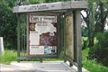
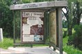
 view gallery view galleryNE7.1 km |  Fort Defiance Camping and RV Park - Cairo, IL Fort Defiance Camping and RV Park - Cairo, IL
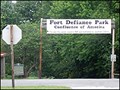
in Municipal Parks and Plazas Called "Fort Defiance State Park" on the sign, because once it was, but not anymore. posted by: YoSam. location: Illinois date approved: 07/11/2014 last visited: never |
 view gallery view galleryNE7.1 km | The Meeting of the Rivers - Cairo, IL in Illinois Historical Markers Tip of confluence of the Ohio and Mississippi Rivers. On the northern bank of each is Fort Defiance, now a city park. posted by: YoSam. location: Illinois date approved: 09/16/2010 last visited: 06/29/2021 |
 view gallery view galleryNE7.1 km |  Fort Defiance - Cairo, IL Fort Defiance - Cairo, IL
in News Article Locations This park is not the actual spot of Lewis and Clark landing, this is land created by the rivers sediment after the Civil War. posted by: YoSam. location: Illinois date approved: 09/20/2017 last visited: 06/03/2021 |
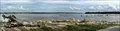 view gallery view galleryNE7.1 km |  Confluence of the Ohio River and Mississippi River - Cairo, IL Confluence of the Ohio River and Mississippi River - Cairo, IL
in American Guide Series The lowest point in the State, the delta on which stands Cairo, once a busy port at the confluence of the Ohio and Mississippi Rivers. posted by: nomadwillie location: Illinois date approved: 01/12/2022 last visited: never |
|