 view gallery view gallery NE10.5 km NE10.5 km
|   Joseph W. Luter, III - Smithfield VA Joseph W. Luter, III - Smithfield VA
in Citizen Memorials Joseph W. Luter, III, CEO Smithfield Foods, donated Windsor Castle Park to the town of Smithfield on May 22, 2010. The park has walking trails,
kayak launch, dog park, fishing pier and pedestrian bridges. posted by:  Don.Morfe Don.Morfe location: Virginia date approved: 02/20/2023 last visited: 02/20/2023 |
 view gallery view galleryNE10.5 km |  H. Woodrow Crook H. Woodrow Crook
in Unintentionally Funny Signs H. Woodrow Crook - Attorney at Law posted by: fatcat161 location: Virginia date approved: 05/02/2009 last visited: never |
 view gallery view galleryNE10.6 km |  Smithfield Va Sidewalks Smithfield Va Sidewalks
in Donated Engraved Bricks and Pavers The sidewalks on Main St in Smithfield Va are paved with bricks, many denoted/dedicated.
posted by: fatcat161 location: Virginia date approved: 04/27/2009 last visited: never |
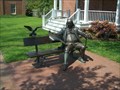 view gallery view galleryNE10.6 km |  Franklin Crater - Ben Franklin Statue Franklin Crater - Ben Franklin Statue
in Extraterrestrial Locations A sit-by-me statue of Ben Franklin in downtown Smithfield, Va. posted by: fatcat161 location: Virginia date approved: 07/09/2009 last visited: 01/01/2014 |
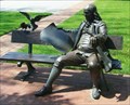 view gallery view galleryNE10.6 km |  Ben Franklin Statue/bench - Smithfield, Va Ben Franklin Statue/bench - Smithfield, Va
in Benjamin Franklin A sit-by-me statue of Ben Franklin in downtown Smithfield, Va.
posted by: Big B Bob location: Virginia date approved: 11/07/2009 last visited: 01/01/2014 |
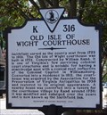 view gallery view galleryNE10.6 km |  Old Isle of Wight Courthouse Old Isle of Wight Courthouse
in Virginia Historical Markers The Old Isle of Wight Courthouse was built in 1752 and is one of Virginia's few surviving court buildings. posted by:  VirginiaSeeker VirginiaSeeker location: Virginia date approved: 08/07/2006 last visited: 04/04/2016 |
 view gallery view galleryNE10.8 km |  Liquid Maze Captain John Smith Chesapeake National Historic Trail - Smithfield, VA Liquid Maze Captain John Smith Chesapeake National Historic Trail - Smithfield, VA
in Signs of History More than 100,000 rivers, streams, and creeks flow through the Chesapeake region. This massive web of waterways includes some 11,000 miles of shoreline---more than that of the entire U.S. West Coast. posted by: Don.Morfe location: Virginia date approved: 01/22/2020 last visited: 09/25/2021 |
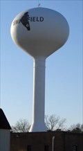 view gallery view galleryNE10.9 km |  Smithfield, VA Water Tower Smithfield, VA Water Tower
in Water Towers Smithfield Water Tower is one of several serving the town and local businesses. posted by: VirginiaSeeker location: Virginia date approved: 03/03/2007 last visited: 12/26/2013 |
 view gallery view galleryNE11.1 km |  Battle of Smithfield-The Town that Wouldn’t Surrender - Smithfield VA Battle of Smithfield-The Town that Wouldn’t Surrender - Smithfield VA
in Civil War Discovery Trail Sites This section of the Pagan River in front of you is where the Union gunboat, USS Smith-Briggs, was run aground and destroyed by local Confederate troops during the January 31-February 1, 1864, Battle of Smith?eld. posted by: Don.Morfe location: Virginia date approved: 07/23/2020 last visited: 10/05/2021 |
 view gallery view galleryNE11.1 km |  Battle of Smithfield - Smithfield VA Battle of Smithfield - Smithfield VA
in Battlefields The troops marched inland, skirmished with local Confederates, then returned to Smith?eld, only to ?nd that the Smith-Briggs had not returned to retrieve them. The next day, February 1, 1864, the Confederates disputed the Union retreat. posted by: Don.Morfe location: Virginia date approved: 11/21/2020 last visited: 10/16/2021 |
 view gallery view galleryNE11.1 km | Battle of Smithfield-The Town that Wouldn’t Surrender - Smithfield VA in U.S. Civil War Sites This section of the Pagan River in front of you is where the Union gunboat, USS Smith-Briggs, was run aground and destroyed by local Confederate troops during the January 31-February 1, 1864, Battle of Smith?eld. posted by: Don.Morfe location: Virginia date approved: 06/27/2023 last visited: 06/27/2023 |
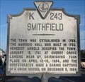 view gallery view galleryNE11.1 km | Smithfield in Virginia Historical Markers Smithfield is famous for hams and peanuts. posted by: VirginiaSeeker location: Virginia date approved: 03/03/2007 last visited: 02/20/2023 |
 view gallery view gallery E11.3 km E11.3 km
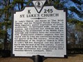
| St. Luke's Church in Virginia Historical Markers St. Luke's Church is one of the oldest churches in Virginia. posted by: VirginiaSeeker location: Virginia date approved: 03/05/2007 last visited: 01/01/2014 |
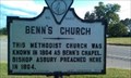 view gallery view galleryE11.3 km | Benn’s Church in Virginia Historical Markers Erected 1926 by Conservation & Development Commission. (Marker Number K-246.) posted by: turnersrugs location: Virginia date approved: 03/29/2013 last visited: never |
 view gallery view gallery SE12.2 km SE12.2 km
| Nansemond Indian Villages in Virginia Historical Markers The principal villages of the Nansemond Indians stood just east of here on the Nansemond River posted by: VirginiaSeeker location: Virginia date approved: 03/03/2007 last visited: 05/26/2013 |
 view gallery view gallerySE12.2 km |  Oakland Christian Church Oakland Christian Church
in Stained Glass Windows Beautiful stained glass windows in the Oakland Christian Church United Church of Christ in Suffolk, VA. posted by: fatcat161 location: Virginia date approved: 04/27/2009 last visited: 05/26/2013 |
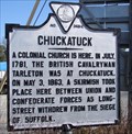 view gallery view gallerySE12.4 km | Chuckatuck in Virginia Historical Markers Chuckatuck is a small village in the expansive city limits of Suffolk. posted by: VirginiaSeeker location: Virginia date approved: 03/03/2007 last visited: 04/02/2013 |
 view gallery view galleryNE14 km |  Residential Lion, Smithfield, VA Residential Lion, Smithfield, VA
in Lion Statues A simple lion in front of a residence in Smithfield, VA. posted by: Team Roberson location: Virginia date approved: 01/02/2006 last visited: 01/02/2008 |
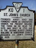 view gallery view gallerySE14.2 km | St. John's Church in Virginia Historical Markers Erected 1961 by Virginia State Library. (Marker Number KO 1.) posted by: turnersrugs location: Virginia date approved: 03/31/2013 last visited: never |
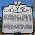 view gallery view gallerySE15.1 km | Dumpling Island in Virginia Historical Markers Dumpling Island was the ceremonial heart of the Nansemond Indians. posted by: VirginiaSeeker location: Virginia date approved: 03/03/2007 last visited: 01/05/2013 |
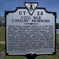 view gallery view gallerySE15.3 km | Civil War Cavalry Skirmish in Virginia Historical Markers Erected 1998 by Department of Historic Resources. (Marker Number UT 28.) posted by: turnersrugs location: Virginia date approved: 03/31/2013 last visited: never |
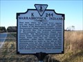 view gallery view galleryNE16.9 km | Warraskoyack Indians in Virginia Historical Markers The Warraskoyack Indians lived along the James and Pagan rivers. posted by: VirginiaSeeker location: Virginia date approved: 03/05/2007 last visited: 12/26/2013 |
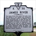 view gallery view galleryE18.3 km | James River in Virginia Historical Markers Erected 1991 by Department of Historic Resources. (Marker Number K 311.) posted by: turnersrugs location: Virginia date approved: 03/29/2013 last visited: 05/26/2015 |
 view gallery view gallery N19 km N19 km
| Fort Huger in Virginia Historical Markers One mile northeast, at Hardy’s Bluff on Lawne’s Neck, existed Fort Huger, a Civil War earthen fortification. posted by: Don.Morfe location: Virginia date approved: 03/16/2020 last visited: 10/20/2021 |
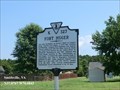 view gallery view galleryN19 km |  Fort Huger - Smithfield VA Fort Huger - Smithfield VA
in Civil Rights Memorials Beginning in July 1861, enslaved and freed blacks assisted in the construction of Fort Huger. posted by: Don.Morfe location: Virginia date approved: 08/24/2023 last visited: 08/25/2023 |
|