 view gallery view gallery S3.7 km S3.7 km
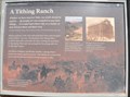
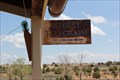
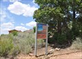
|   A Tithing Ranch A Tithing Ranch
in Arizona Historical Markers This Historical Marker is mounted on a steel post near one of the stone ranch buildings on the grounds of Pipe Spring National Monument about 15 miles west of Fredonia, Arizona. posted by:  brwhiz brwhiz location: Arizona date approved: 12/01/2012 last visited: 08/04/2014 |
 view gallery view galleryS3.7 km | Staking a Claim in Arizona Historical Markers This Historical Marker is mounted on a steel post near Windsor Castle on the grounds of Pipe Spring National Monument about 15 miles west of Fredonia, Arizona. posted by: brwhiz location: Arizona date approved: 12/01/2012 last visited: 08/04/2014 |
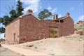
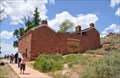 view gallery view galleryS3.7 km |  Winsor Castle ~ Pipe Spring National Monument, Arizona Winsor Castle ~ Pipe Spring National Monument, Arizona
in Historic Forts This fortified ranch house is part of Pipe Springs National Monument, about 15 miles west of Fredonia, Arizona. posted by: brwhiz location: Arizona date approved: 11/27/2012 last visited: 08/04/2014 |
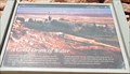
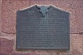 view gallery view galleryS3.7 km | Pipe Springs National Monument in Arizona Historical Markers A Utah historical marker located in Arizona. posted by: ggmorton location: Arizona date approved: 10/15/2007 last visited: 08/04/2014 |
 view gallery view galleryS3.7 km |  FIRST -- Telegraph in AZ, Pipe Spring Natl. Mon., Kaibab AZ FIRST -- Telegraph in AZ, Pipe Spring Natl. Mon., Kaibab AZ
in First of its Kind The Desert Telegraph, which linked the Mormon pioneer outpost of Pipe Spring with Salt Lake City and then the world, commenced operations in 1871. posted by: Benchmark Blasterz location: Arizona date approved: 08/26/2014 last visited: 08/27/2014 |
 view gallery view galleryS3.7 km |  Pipe Spring -- Pipe Spring National Monument, Kaibab AZ Pipe Spring -- Pipe Spring National Monument, Kaibab AZ
in Natural Springs A natural spring, "discovered" by Mormon Pioneers in 1858, had supported Ancestral Puebloan Indian tribes and agriculture here for over 1000 years. posted by: Benchmark Blasterz location: Arizona date approved: 08/28/2014 last visited: 10/10/2018 |
 view gallery view galleryS3.7 km |  Windsor Castle -- Pipe Spring National Monument, Kaibab AZ Windsor Castle -- Pipe Spring National Monument, Kaibab AZ
in Spring Houses Unique spring house incorporated as part of the Windsor Castle fort, which was built as a Mormon pioneer outpost in the late 1860s. posted by: Benchmark Blasterz location: Arizona date approved: 08/27/2014 last visited: 10/10/2018 |
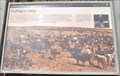
 view gallery view galleryS3.7 km | When the Good Grass Goes in Arizona Historical Markers This Historical Marker is mounted on a steel post near one of the stone ranch buildings on the grounds of Pipe Spring National Monument about 15 miles west of Fredonia, Arizona. posted by: brwhiz location: Arizona date approved: 12/01/2012 last visited: 08/04/2014 |
 view gallery view galleryS3.7 km |  Animal Tracks on the Sidewalk ~ Pipe Spring National Monument Animal Tracks on the Sidewalk ~ Pipe Spring National Monument
in Petrosomatoglyphs These tracks are immortalized in the surface of the concrete walkway at Pipe Spring National Monument west of Fredonia, Arizona. posted by: brwhiz location: Arizona date approved: 11/19/2012 last visited: 08/04/2014 |
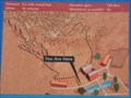 view gallery view galleryS3.7 km |  Ridge Trail Trailhead ~ Pipe Spring National Monument Ridge Trail Trailhead ~ Pipe Spring National Monument
in 'You Are Here' Maps You Are Here at the Ridge Trail Information Sign at Pipe Spring National Monument west of Fredonia, Arizona. posted by: brwhiz location: Arizona date approved: 11/19/2012 last visited: 08/04/2014 |
 view gallery view galleryS3.7 km |  Ridge Trail ~ Pipe Spring National Monument Ridge Trail ~ Pipe Spring National Monument
in Hiking and walking trailheads Ridge Trail climbs to the top of the bluff overlooking Pipe Spring National Monument west of Fredonia, Arizona. posted by: brwhiz location: Arizona date approved: 11/19/2012 last visited: 08/04/2014 |
 view gallery view galleryS3.7 km |  Ridge Trail ~ Pipe Spring National Monument Ridge Trail ~ Pipe Spring National Monument
in Flora and Fauna Information Signs This Flora and Fauna Information Sign is located at the start of the Ridge Trail on Pipe Spring National Monument west of Fredonia, Arizona. posted by: brwhiz location: Arizona date approved: 11/26/2012 last visited: 08/04/2014 |
 view gallery view galleryS3.7 km | A Good Drink of Water in Arizona Historical Markers This Historical Marker is mounted on a steel post near a small, spring-fed pool of water on the grounds of Pipe Spring National Monument about 15 miles west of Fredonia, Arizona. posted by: brwhiz location: Arizona date approved: 12/01/2012 last visited: 08/04/2014 |
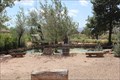
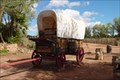 view gallery view galleryS3.7 km |  Pipe Spring National Monument Pipe Spring National Monument
in Covered Wagons This covered wagon is on the grounds of Pipe Spring National Monument. posted by: ggmorton location: Arizona date approved: 10/02/2007 last visited: 10/10/2018 |
 view gallery view galleryS3.7 km | Pipe Spring National Monument Native Vegetation Restoration in Flora and Fauna Information Signs This Flora and Fauna Sign is mounted on a steel post at the edge of the garden on the grounds of Pipe Spring National Monument about 15 miles west of Fredonia, Arizona. posted by: brwhiz location: Arizona date approved: 11/28/2012 last visited: 10/10/2018 |
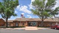
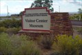
 view gallery view galleryS3.9 km |  Pipe Spring National Monument Visitor Center Pipe Spring National Monument Visitor Center
in Ranger Stations The Pipe Spring National Monument Visitor Center is located at 406 N Pipe Spring Road about 15 miles west of Fredonia, Arizona. posted by: brwhiz location: Arizona date approved: 11/27/2012 last visited: 06/09/2015 |
 view gallery view galleryS3.9 km |  Kaibab Band of Paiute Indians Cultural Museum Kaibab Band of Paiute Indians Cultural Museum
in History Museums The Kaibab Band of Paiute Indians Cultural Museum is located at 406 N Pipe Spring Road about 15 miles west of Fredonia, Arizona. posted by: brwhiz location: Arizona date approved: 11/27/2012 last visited: 08/31/2014 |
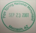 view gallery view galleryS3.9 km |  Pipe Spring National Monument - Moccasin, AZ Pipe Spring National Monument - Moccasin, AZ
in NPS Passport Cancellation Stations An old Mormon fort in North western Arizona. posted by: ggmorton location: Arizona date approved: 10/02/2007 last visited: 03/04/2022 |
 view gallery view galleryS3.9 km | ") Pipe Spring National Monument Pipe Spring National Monument
in National Parks (U.S.) A small educational and historical national monument in northwestern Arizona. posted by: ggmorton location: Arizona date approved: 11/04/2007 last visited: 02/27/2018 |
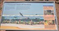 view gallery view galleryS3.9 km | A Thousand Years of Gardens in Arizona Historical Markers This Historical Marker is mounted on a steel post in the garden on the grounds of Pipe Spring National Monument about 15 miles west of Fredonia, Arizona. posted by: brwhiz location: Arizona date approved: 12/01/2012 last visited: 08/04/2014 |
 view gallery view gallery N15.4 km N15.4 km
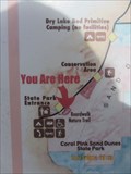
| You are at Coral Pink Sand Dunes, Utah in 'You Are Here' Maps This trio of information boards includes an all-important item: a YOU ARE HERE MAP.
N 37° 02.099 W 112° 43.883 posted by: Queens Blessing location: Utah date approved: 11/24/2012 last visited: 09/02/2013 |
 view gallery view galleryN15.8 km |  Coral Pink Sand Dunes State Park - Utah Coral Pink Sand Dunes State Park - Utah
in State/Provincial Parks Coral Pink Sand Dunes State Park - Utah posted by: kJfishman location: Utah date approved: 09/28/2010 last visited: 10/14/2012 |
 view gallery view gallery E16.7 km E16.7 km
|  Kaibab Paiute Indian Reservation ~ Fredonia, Arizona Kaibab Paiute Indian Reservation ~ Fredonia, Arizona
in Nations Within Nations The Tribal Headquarters of the Kaibab Band of Paiute Indians is located on the northwest corner of the junction of Arizona Highway 389 and Pipe Spring Road. posted by: brwhiz location: Arizona date approved: 11/27/2012 last visited: 08/04/2014 |
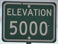 view gallery view gallery W17.5 km W17.5 km
|  Elevation 5000 Feet Elevation 5000 Feet
in Elevation Signs This Elevation Sign is located on the northeast side of Arizona Highway 389, just southeast of Colorado City, Arizona. posted by: brwhiz location: Arizona date approved: 05/20/2013 last visited: 03/04/2022 |
 view gallery view galleryE18.8 km | Fredonia, Arizona ~ Elevation 4671 feet in Elevation Signs This Elevation sign is at the western city limits of Fredonia, Arizona on Arizona Highway 389 at Stagger Mountain Road. posted by: brwhiz location: Arizona date approved: 11/19/2012 last visited: 08/04/2014 |
|