 view gallery view gallery E3.4 km E3.4 km
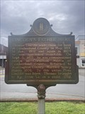
|   Lincoln's Father Here #885 - Burkesville KY Lincoln's Father Here #885 - Burkesville KY
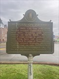
in Kentucky Historical Markers Lincoln's Father Here #885 located in the Cumberland County Courthouse square in Burkesville, KY. posted by:  Team Geologynut Team Geologynut location: Kentucky date approved: 04/08/2023 last visited: never |
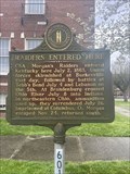 view gallery view galleryE3.4 km | Raiders Entered Here #601 - Burkesville KY in Kentucky Historical Markers Raiders Entered Here #601 located in the Cumberland County Courthouse square in Burkesville, KY. posted by: Team Geologynut location: Kentucky date approved: 04/07/2023 last visited: never |
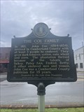 view gallery view galleryE3.4 km | The Coe Family #2614 - Burkesville KY in Kentucky Historical Markers The Coe Family #2614 located in the Cumberland County Courthouse square in Burkesville, KY. posted by: Team Geologynut location: Kentucky date approved: 04/08/2023 last visited: never |
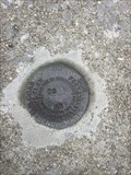
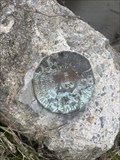
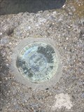
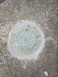
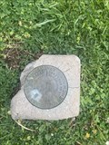 view gallery view galleryE3.4 km |  S 43 (GB1332) - Burkesville, KY S 43 (GB1332) - Burkesville, KY
in U.S. Benchmarks A USC&G benchmark disk on the grounds of the old Cumberland County Courthouse. posted by: Team Geologynut location: Kentucky date approved: 04/10/2023 last visited: never |
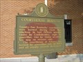
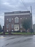 view gallery view galleryE3.4 km |  Cumberland County Courthouse - Burkesville, KY Cumberland County Courthouse - Burkesville, KY
in Courthouses Cumberland County Courthouse located in the middle of Burkesville Kentucky. posted by: Team Geologynut location: Kentucky date approved: 04/07/2023 last visited: never |
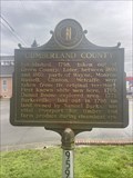 view gallery view galleryE3.4 km | Cumberland County #959 - Burkesville KY in Kentucky Historical Markers Cumberland County #959 located in the Cumberland County Courthouse square in Burkesville, KY. posted by: Team Geologynut location: Kentucky date approved: 04/08/2023 last visited: never |
 view gallery view galleryE3.4 km | Morgan ~ On To Ohio #515 - Burkesville KY in Kentucky Historical Markers Morgan ~ On To Ohio #515 located in the Cumberland County Courthouse square in Burkesville, KY. posted by: Team Geologynut location: Kentucky date approved: 04/08/2023 last visited: never |
 view gallery view gallery NW3.7 km NW3.7 km
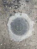
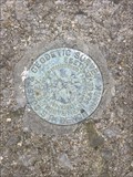
| C 251 (GB1342) - Burkesville, Cumberland County KY in U.S. Benchmarks An easy to find USC&G benchmark on a bridge abutment on Glasgow Rd (Hwy 90) NW of Burkesville KY. I parked 175ft west where the shoulder was wide. posted by: Team Geologynut location: Kentucky date approved: 04/10/2023 last visited: never |
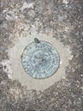
 view gallery view galleryNW7.7 km | N 252 (GB1536) - Cumberland County, KY in U.S. Benchmarks A USC&G benchmark on a culvert headwall on Mud Camp Rd. (state hwy 100). Pull off right next to it. posted by: Team Geologynut location: Kentucky date approved: 04/10/2023 last visited: never |
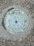
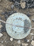
 view gallery view galleryNW9.5 km | H 251 (GB1346) - Burkesville, Cumberland County KY in U.S. Benchmarks An easy to find USC&G benchmark on a bridge abutment on Glasgow Rd (Hwy 90) NW of Burkesville KY. I parked across the street at a large parking lot. posted by: Team Geologynut location: Kentucky date approved: 04/10/2023 last visited: never |
 view gallery view gallery W13 km W13 km
| R 252 (GB2151) - Cumberland County, KY in U.S. Benchmarks A USC&G benchmark on a bridge abutment on Mud Camp Rd. (state hwy 100). posted by: Team Geologynut location: Kentucky date approved: 04/10/2023 last visited: never |
 view gallery view gallery SW13.4 km SW13.4 km
| T 266 (GB2143) - Monroe County KY in U.S. Benchmarks A USC&G benchmark on a bridge abutment on Mud Camp Rd. (state hwy 100). posted by: Team Geologynut location: Kentucky date approved: 04/10/2023 last visited: never |
 view gallery view gallerySW14.6 km | S 266 (GB2167) - Monroe County, KY in U.S. Benchmarks A USC&G benchmark on a culvert headwall on Center Point Rd. (state hwy 100). Pull off right next to it posted by: Team Geologynut location: Kentucky date approved: 04/10/2023 last visited: never |
 view gallery view gallerySW16.4 km | Q 266 (GB2165) - Monroe County, KY in U.S. Benchmarks A USC&G benchmark on a culvert headwall on Center Point Rd. (state hwy 100). Pull off right next to it posted by: Team Geologynut location: Kentucky date approved: 04/10/2023 last visited: never |
 view gallery view gallerySW18.5 km | N 266 (GB2163) - Monroe County, KY in U.S. Benchmarks A USC&G benchmark on a bridge abutment on Center Point Rd. (state hwy 100). posted by: Team Geologynut location: Kentucky date approved: 04/11/2023 last visited: never |
 view gallery view gallery SE23.2 km SE23.2 km
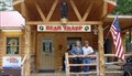
|  Bear Trapp Country Store-Byrdstown,TN Bear Trapp Country Store-Byrdstown,TN
in Bait Shops Popular bait shop located in Byrdstown,TN
posted by:  Countrydragon Countrydragon location: Tennessee date approved: 12/02/2009 last visited: 12/01/2009 |
 view gallery view gallerySW25.4 km | Moore's Mill #2041 - Tompkinsville, KY in Kentucky Historical Markers Kentucky Historical Marker #2041 SE of Tompkinsville on State Hwy 163.Front side has text, back side has two old metal photos of the mill. posted by: Team Geologynut location: Kentucky date approved: 04/24/2023 last visited: never |
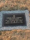 view gallery view galleryE26.1 km |  Garlin Murl Conner-Albany, KY Garlin Murl Conner-Albany, KY
in Medal Of Honor Resting Places World War II Medal of Honor Recipient for action at Houssen, France on January 24, 1945. He was awarded the Medal of Honor on June 26, 2018. He is buried in Memorial Hill Cemetery, Albany, KY. posted by: Don.Morfe location: Kentucky date approved: 12/21/2018 last visited: 12/07/2021 |
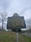
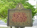 view gallery view galleryE26.1 km | Civil War Terrorist in Kentucky Historical Markers A marker on the square in Albany. posted by: ggmorton location: Kentucky date approved: 10/17/2007 last visited: 09/02/2007 |
 view gallery view galleryE26.1 km | Courthouse Burned in Kentucky Historical Markers A marker on the square in Albany. posted by: ggmorton location: Kentucky date approved: 10/17/2007 last visited: 09/02/2007 |
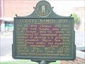 view gallery view galleryE26.1 km | Clinton County Named, 1835 in Kentucky Historical Markers A historical marker on the square in Albany, KY. posted by: ggmorton location: Kentucky date approved: 09/18/2007 last visited: 09/02/2007 |
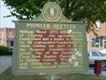 view gallery view galleryE26.1 km | Pioneer Settler in Kentucky Historical Markers A marker on the square in Albany. posted by: ggmorton location: Kentucky date approved: 10/17/2007 last visited: 09/02/2007 |
 view gallery view galleryW26.2 km | G 266 (GB2153) - Tompkinsville, KY in U.S. Benchmarks A USC&G benchmark on a bridge abutment on N Magnolia St. in Tompkinsville KY. posted by: Team Geologynut location: Kentucky date approved: 04/11/2023 last visited: never |
 view gallery view galleryW26.9 km | Monroe County Tompkinsville #1093 - Tompkinsville, KY in Kentucky Historical Markers Kentucky Historical Marker #1093 on the Monroe County Courthouse grounds in Tompkinsville, KY posted by: Team Geologynut location: Kentucky date approved: 04/24/2023 last visited: never |
 view gallery view gallery S26.9 km S26.9 km
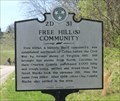
|  Free Hill(s) Community - Celina TN Free Hill(s) Community - Celina TN
in Civil Rights Memorials Free Hill(s), a historic Black community established near Celina before the Civil War by former slaves of Virginia Hill. Hill brought her slaves from North Carolina to then Overton County, settled and freed them. posted by: Don.Morfe location: Tennessee date approved: 11/09/2022 last visited: 11/10/2022 |
|