 view gallery view gallery E0.3 km E0.3 km
|   Moapa Valley National Wildlife Refuge Moapa Valley National Wildlife Refuge
in Wikipedia Entries A small wildlife refuge for the Moapa Dace. Open weekends during the winter. posted by:  ChapterhouseInc ChapterhouseInc location: Nevada date approved: 06/03/2011 last visited: 06/01/2011 |
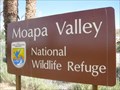 view gallery view galleryE0.3 km |  Moapa Valley National Wildlife Refuge - Nevada Moapa Valley National Wildlife Refuge - Nevada
in National Wildlife Refuges A small wildlife refuge for the Moapa Dace. Open weekends during the winter. posted by: ChapterhouseInc location: Nevada date approved: 06/24/2011 last visited: 06/01/2011 |
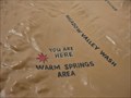 view gallery view galleryE0.3 km |  You are at the Warm Springs Area - Moapa NWR You are at the Warm Springs Area - Moapa NWR
in 'You Are Here' Maps A topographic map in this Wildlife Refuge for the Moapa Dace shows the surrounding mountain ranges. posted by: ChapterhouseInc location: Nevada date approved: 06/03/2011 last visited: 06/01/2011 |
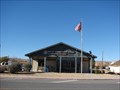
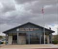
 view gallery view gallery SE13.2 km SE13.2 km
|  Moapa, Nevada 89025 Moapa, Nevada 89025
in U.S. Post Offices The Post Office for Moapa / Glendale Nevada. posted by: JacobBarlow location: Nevada date approved: 08/16/2007 last visited: 11/25/2011 |
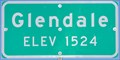 view gallery view gallerySE13.8 km |  Glendale Nevada South Town Limits ~ Elevation 1524 Glendale Nevada South Town Limits ~ Elevation 1524
in Elevation Signs This elevation sign is at the souithern limits of Glendale, Nevada, at the junction of Nevada Highway 168 and Glendale Blvd. posted by: brwhiz location: Nevada date approved: 03/15/2012 last visited: 03/03/2012 |
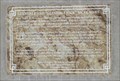 view gallery view galleryE14 km |  Glendale and "Glendale Nick" Nicolaides Glendale and "Glendale Nick" Nicolaides
in Nevada Historical Markers This Historical Marker is at Arco Gas Station & Restaurant at 2300 Glendale Boulevard in Glendale, Nevada. It just north of the I-15 (exit 91). posted by: PeterNoG location: Nevada date approved: 03/15/2018 last visited: 11/14/2023 |
 view gallery view galleryE14 km |  Glendale and "Glendale Nick" Nicolaides Glendale and "Glendale Nick" Nicolaides
in E Clampus Vitus Historical Markers This E Clampus Vitus Historical Marker is at Arco Gas Station & Restaurant at 2300 Glendale Boulevard in Glendale, Nevada. It just north of the I-15 (exit 91). posted by: PeterNoG location: Nevada date approved: 02/22/2018 last visited: 11/09/2023 |
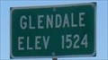 view gallery view galleryE14.3 km | Glendale Elev 1524 - Clark County, Nevada in Elevation Signs Town sign on the north end of town as you exit I-15 S.B. at Glendale. posted by: nvtriker location: Nevada date approved: 05/18/2009 last visited: never |
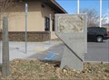
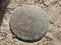
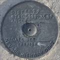
 view gallery view gallery S14.8 km S14.8 km
|  UTE (GR1909) - Clark County, NV UTE (GR1909) - Clark County, NV
in U.S. Benchmarks Benchmark just off of the Moapa Indian Reservation. posted by: mojave_rattler location: Nevada date approved: 12/22/2011 last visited: never |
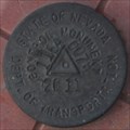
 view gallery view galleryS15.1 km | Nevada Highway Department ROW ~ 829014H in U.S. Benchmarks An older-style Nevada Highway Department Right-of-Way marker in the center median of Interstate 15 about nine miles northeast of the Valley of Fire exit. posted by: brwhiz location: Nevada date approved: 03/27/2012 last visited: never |
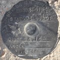 view gallery view galleryS15.1 km | Nevada Highway Department ROW ~ 140228H in U.S. Benchmarks An older-style Nevada Highway Department Right-of-Way marker in the center median of Interstate 15 about nine miles northeast of the Valley of Fire exit. posted by: brwhiz location: Nevada date approved: 03/27/2012 last visited: never |
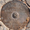 view gallery view galleryS15.1 km | Nevada Highway Department ROW ~ 829013H in U.S. Benchmarks This Nevada Department of Transportation Right-of-Way marker is located on the southeast side of Interstate 15 at Milepost 84.1. posted by: brwhiz location: Nevada date approved: 09/21/2012 last visited: never |
 view gallery view gallerySE17.4 km | Muddy River monitor Station Marker in U.S. Benchmarks Bench mark with no id near some sort of monitor station. Sign on station is eroded. but it still functioning. posted by:  hauver.1 hauver.1 location: Nevada date approved: 02/06/2011 last visited: never |
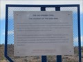 view gallery view galleryE18.2 km | The Old Spanish Trail - The Journey of the Dead Man in Nevada Historical Markers This Nevada Historical Marker is in a wide pullout on North Moapa Valley Boulevard (NV 169) about 500 yards south of I-15 (Exit 93 - Loganville/Overton). posted by: PeterNoG location: Nevada date approved: 03/15/2018 last visited: 10/03/2021 |
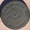
 view gallery view galleryE18.5 km | Nevada Highway Department ROW ~ 1164007 M in U.S. Benchmarks An Nevada Department of Transportation Right-of-Way marker on the east side of Interstate 15 about two miles northeast of the Moapa Valley exit. posted by: brwhiz location: Nevada date approved: 03/27/2012 last visited: never |
 view gallery view gallery W19.3 km W19.3 km
| NDOT 1035082M ~ US Highway 93 in U.S. Benchmarks This Nevada Department of Transportation Right-of-Way marker is located on the east side of US Highway 93 about 24.3 miles northwest of the junction with Interstate Highway 15 at Exit 64 at Milepost CL77. posted by: brwhiz location: Nevada date approved: 07/29/2013 last visited: never |
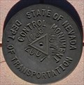 view gallery view galleryW19.3 km | NDOT 1035067M ~ US Highway 93 in U.S. Benchmarks This Nevada Department of Transportation Right-of-Way marker is located on the east side of US Highway 93 about 19.8 miles northwest of the junction with Interstate Highway 15 at Exit 64 at Milepost CL72.5. posted by: brwhiz location: Nevada date approved: 07/29/2013 last visited: never |
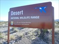 view gallery view galleryW21.2 km | Desert National Wildlife Range - near Alamo, NV in National Wildlife Refuges Eastern boundary of the Desert NWR. posted by: jiggs11 location: Nevada date approved: 04/21/2016 last visited: never |
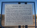 view gallery view gallerySE21.7 km | Moapa Valley in Nevada Historical Markers Rich in prehistoric, pueblo-type culture, and noted by the explorer Jedediah Smith in 1826, Moapa Valley is crossed by the old Spanish Trail. posted by: JacobBarlow location: Nevada date approved: 12/31/2007 last visited: 10/03/2021 |
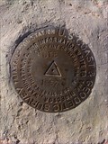
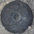
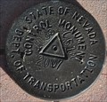
 view gallery view galleryE22.5 km |  Benchmark Z 50 AZ MK Nevada Benchmark Z 50 AZ MK Nevada
in Azimuth Benchmarks Location:
In CLARK county, NV
Designation:
Z 50 AZ MK
Marker Type:
azimuth mark disk
Setting:
set into the top of a round concrete monument
Stability:
May hold, but of type commonly subject to surface motion. posted by: datenhamster location: Nevada date approved: 07/07/2014 last visited: never |
 view gallery view galleryS22.7 km | Nevada Highway Department ROW ~ 289009 H in U.S. Benchmarks An older-style Nevada Highway Department Right-of-Way marker on the southeast side of Interstate 15 about three-fourths mile northeast of the Valley of Fire exit. posted by: brwhiz location: Nevada date approved: 03/26/2012 last visited: never |
 view gallery view gallery SW23.3 km SW23.3 km
| NDOT 1035051M ~ US Highway 93 in U.S. Benchmarks This Nevada Department of Transportation Right-of-Way marker is located on the east side of US Highway 93 about 15 miles northwest of the junction with Interstate Highway 15 at Exit 64 at Milepost CL67.7. posted by: brwhiz location: Nevada date approved: 07/29/2013 last visited: never |
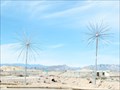 view gallery view galleryS23.7 km |  Fireworks Trees at Moapa Paiute Travel Plaza, NV Fireworks Trees at Moapa Paiute Travel Plaza, NV
in Fireworks Trees The trees are located at a rest stop between Las Vegas and the Valley of Fire. Real fireworks are available in the gift shop. posted by: Go Boilers! location: Nevada date approved: 03/16/2009 last visited: 05/23/2017 |
 view gallery view gallerySE24.3 km | Logandale, Nevada 89021 in U.S. Post Offices Logandale, Nevada's Post Office. posted by: JacobBarlow location: Nevada date approved: 12/28/2007 last visited: 09/24/2013 |
 view gallery view gallerySE24.3 km | Logandale, Nevada in Wikipedia Entries Logandale, originally named Logan, is an unincorporated town in Clark County, Nevada. posted by: brwhiz location: Nevada date approved: 07/08/2011 last visited: 09/24/2013 |
|