 view gallery view gallery W2.1 km W2.1 km
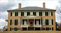
|   Prestwould Plantation Prestwould Plantation
in Virginia Historical Markers Sir Peyton Skipwith, originally of England and then Virginia, built this home in 1794. Prestwould is the most complete gentry home in Virginia. Many of the original outbuildings and Lady Jean's Garden remain. The original two-family slave house still stands on the manor house property. The site has one of the largest collections of slave writings in the country. Detailing life from the plantation from the slave perspective, it has attracted scholarly attention. posted by:  showbizkid showbizkid location: Virginia date approved: 07/30/2006 last visited: 06/12/2009 |
 view gallery view gallery S2.1 km S2.1 km
| Occaneechi Indians in Virginia Historical Markers Marker regarding indigenous people who preceded the white settlers in this area. They were driven out and relocated in North Carolina. This marker is on U.S. Highway 58 east of Clarksville. The marker was placed in 2000 and replaces an earlier, less detailed marker placed in 1957 (see gallery). posted by: showbizkid location: Virginia date approved: 07/29/2006 last visited: 07/01/2016 |
 view gallery view gallery SW3.5 km SW3.5 km
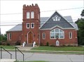
|  Mt. Zion Baptist Church, Clarksville, Virginia Mt. Zion Baptist Church, Clarksville, Virginia
in This Old Church Mt. Zion Baptist Church is a black congregation in Clarksville. The church building dates to 1871. posted by: showbizkid location: Virginia date approved: 08/02/2006 last visited: 07/29/2006 |
 view gallery view gallerySW3.5 km |  Clarksville, Virginia Clarksville, Virginia
in City and Town Halls Clarksville, Virginia's Town Hall. posted by: showbizkid location: Virginia date approved: 08/01/2006 last visited: 04/14/2017 |
 view gallery view gallerySW3.9 km |  Clarksville Jewelry, Clarksville, Virginia Clarksville Jewelry, Clarksville, Virginia
in Town Clocks Town clock in the downtown business district of Clarksville, Virginia. posted by: showbizkid location: Virginia date approved: 01/24/2006 last visited: 04/14/2017 |
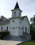
 view gallery view gallerySW3.9 km | Jamieson Memorial United Methodist Church, Clarksville, Virginia in This Old Church Jamieson Memorial United Methodist Church is located in Clarksville in southern Virginia. The building was constructed in 1901. posted by: showbizkid location: Virginia date approved: 08/02/2006 last visited: 07/29/2006 |
 view gallery view gallerySW4.3 km |  Clarksville School - Clarksville, Virginia Clarksville School - Clarksville, Virginia
in Former Schools Former school building which served the community of Clarksville, Virginia. posted by:  BruceS BruceS location: Virginia date approved: 11/14/2007 last visited: 12/01/2022 |
 view gallery view gallerySW4.3 km |  Clarksville Police Department - Clarksville, Virginia Clarksville Police Department - Clarksville, Virginia
in Police Stations Police department serving the community of Clarksville in southern Virginia. posted by: BruceS location: Virginia date approved: 11/12/2007 last visited: never |
 view gallery view gallerySW4.3 km |  1934 - Clarksville School - Clarksville, Virginia 1934 - Clarksville School - Clarksville, Virginia
in Dated Buildings and Cornerstones Former school building which served the community of Clarksville, Virginia. posted by: BruceS location: Virginia date approved: 11/26/2008 last visited: never |
 view gallery view gallerySW4.3 km |  Mecklenburg County Veterans Memorial - Clarksville, Virginia Mecklenburg County Veterans Memorial - Clarksville, Virginia
in Non-Specific Veteran Memorials Veterans memorial honoring veterans from the Revolutionary War to the War in Iraq located in Clarksville, Virginia. posted by: BruceS location: Virginia date approved: 11/15/2007 last visited: never |
 view gallery view gallerySW4.8 km |  Clarksville Volunteer Fire Department, Clarksville, Virginia Clarksville Volunteer Fire Department, Clarksville, Virginia
in Firehouses Solid Brick Firehouse in Clarksville, Virginia. posted by: showbizkid location: Virginia date approved: 01/24/2006 last visited: never |
 view gallery view gallerySW4.8 km |  Clarksville, Virginia Water Tower Clarksville, Virginia Water Tower
in Water Towers Municipal Water Tower in Clarksville, Virginia posted by: showbizkid location: Virginia date approved: 01/24/2006 last visited: 06/21/2006 |
 view gallery view galleryS6 km | Russell Stover Candy Factory Water Tower, Clarksville, Virginia in Water Towers Water Tower at the old Russell Stover Candy Factory in Clarksville, Virginia. posted by: showbizkid location: Virginia date approved: 01/24/2006 last visited: never |
 view gallery view gallery NE6 km NE6 km
|  Skipwith, VA 23968 Skipwith, VA 23968
in U.S. Post Offices Located at 6000 Skipwith Rd, Skipwith, VA posted by:  nomadwillie nomadwillie location: Virginia date approved: 02/10/2013 last visited: never |
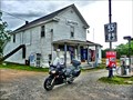 view gallery view galleryNE6 km |  Skipwith Grocery - Skipwith VA Skipwith Grocery - Skipwith VA
in The Local Neighborhood Grocer Definitely local because it was out of the way to get there. posted by: nomadwillie location: Virginia date approved: 02/10/2013 last visited: never |
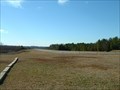 view gallery view galleryS6.1 km |  Marks Municpal Airport, Clarksville, Virginia Marks Municpal Airport, Clarksville, Virginia
in Airports Marks Municipal Airport, Clarksville, VA. posted by: showbizkid location: Virginia date approved: 01/28/2006 last visited: never |
 view gallery view gallery NW11.1 km NW11.1 km
| St. Level Baptist Church, Clarksville, Virginia in Country Churches An oddly named, yet classically built country church well north of Clarksville, Virginia. posted by: showbizkid location: Virginia date approved: 08/20/2006 last visited: 08/08/2006 |
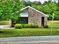
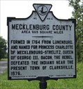 view gallery view galleryNW11.3 km | Mecklenburg County - Charlotte County in Virginia Historical Markers This is a two-sided county line marker on U.S. Hwy 15 south, north of Clarksville. This marker was placed in 1928. posted by: showbizkid location: Virginia date approved: 08/01/2006 last visited: 06/12/2009 |
 view gallery view gallery E11.7 km E11.7 km
| Boydton and Petersburg Plank Road in Virginia Historical Markers The Boydton and Petersburg Plank Road, used by horse-drawn wagons carrying tobacco to the market and by stagecoach traffic, was an early means of transportation in the area. It had a short history, however. While it was completed in 1853, by 1860 it was declared unsafe due to heavy wear, poor timber and a bridge collapse. posted by: showbizkid location: Virginia date approved: 08/02/2006 last visited: 04/27/2009 |
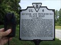 view gallery view galleryE11.7 km |  Boydton and Petersburg Plank Road Boydton and Petersburg Plank Road
in Plank Roads A Virginia State Historic Marker commemorates the Boydton and Petersburg Plank Road, which was located near the marker. The plank road was built between 1851 and 1853, but by 1860 most of the road was declared unsafe. It had received too much use and was built of poorly suited timber. posted by: showbizkid location: Virginia date approved: 08/02/2006 last visited: 07/01/2016 |
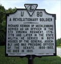 view gallery view galleryE11.7 km | A Revolutionary Soldier - Richard Kennon in Virginia Historical Markers Marker is one of four along eastbound U.S. west of Boydton. It was placed in 1962. posted by: showbizkid location: Virginia date approved: 07/29/2006 last visited: 07/01/2016 |
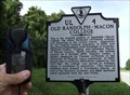 view gallery view galleryE11.7 km | Old Randolph-Macon College in Virginia Historical Markers This marker notes the location of the original campus of Randolph-Macon College, which stood in Boydton from 1832 to 1868. Economic problems caused the college to relocate in 1868. While other institutions have occupied the campus, it is currently abandoned, although some faculty homes are now private residences. This marker was placed in 1994. posted by: showbizkid location: Virginia date approved: 08/02/2006 last visited: 07/01/2016 |
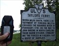 view gallery view galleryE11.7 km | Taylor's Ferry in Virginia Historical Markers This marker details the movement of the Virginia Militia during the Revolutionary War. In February, 1781, a detachment of the militia crossed the Roanoke River seven miles south at Taylor's Ferry on their way to join General Nathanial Greene's Colonial Southern Army. This marker was placed in 1930. posted by: showbizkid location: Virginia date approved: 07/31/2006 last visited: 07/01/2016 |
 view gallery view galleryS12.1 km | Occaneechi Indians in Virginia Historical Markers Marker regarding indigenous people who preceded the white settlers in this area. They were driven out and relocated in North Carolina. This marker is on U.S. Highway 58 east of Clarksville. The marker was placed in 2000 when the state was replacing most markers about Native Americans due to non-politically correct language. posted by: showbizkid location: Virginia date approved: 07/30/2006 last visited: 10/23/2007 |
 view gallery view galleryS12.4 km |  Virginia Border, US Route 15 North Virginia Border, US Route 15 North
in Border Crossings "Welcome to Virginia" on US Route 15 North. posted by: showbizkid location: Virginia date approved: 01/23/2006 last visited: never |
|