 view gallery view gallery SE8.7 km SE8.7 km
|   The Great Dismal Swamp The Great Dismal Swamp
in Underground Railroad Sites Now a Wildlife Refuge National Park, The Great Dismal Swamp was the home of thousands of escaped slaves who formed Maroon communities in the swamp. posted by:  Anyanwu Anyanwu location: Virginia date approved: 08/25/2013 last visited: never |
 view gallery view gallery NE10.5 km NE10.5 km
|  Suffolk Seaboard Passenger Station Suffolk Seaboard Passenger Station
in Train Stations/Depots Suffolk Seabord Passenger Station now serves as an interesting tourist stop for railroad enthusiasts. posted by:  VirginiaSeeker VirginiaSeeker location: Virginia date approved: 03/04/2007 last visited: 02/19/2022 |
 view gallery view galleryNE11.6 km |  Suffolk Free WiFi (SBUX) Suffolk Free WiFi (SBUX)
in Wi-Fi Hotspots Suffolk Free WiFi Location posted by: S&SLaird location: Virginia date approved: 04/02/2013 last visited: 03/07/2016 |
 view gallery view gallery W11.6 km W11.6 km
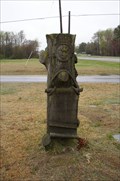
|  John G Holland, Holland, VA John G Holland, Holland, VA
in Woodmen of the World Grave Markers/Monuments John G Holland May 24, 1897 - Nov. 16, 1918 posted by: lainva location: Virginia date approved: 04/01/2011 last visited: never |
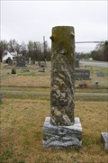 view gallery view galleryW11.6 km | Joseph F. Holland Feb. 14, 1859 - Aug. 20, 1919 in Woodmen of the World Grave Markers/Monuments One of several WOW markers in cemetary posted by: lainva location: Virginia date approved: 04/01/2011 last visited: never |
 view gallery view galleryW11.6 km | Jet H. Howell, Holland United Christian Cemetary, Holland VA in Woodmen of the World Grave Markers/Monuments One of several WOW markers in this cemetary. posted by: lainva location: Virginia date approved: 04/01/2011 last visited: never |
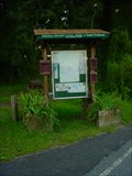
 view gallery view galleryW13 km |  First Ruritan Club First Ruritan Club
in Virginia Historical Markers Virginia Historical Marker in the Holland area of Suffolk Virginia. The First Ruritan club was founded across the street from this marker on May 21, 1928. posted by: jdhowell location: Virginia date approved: 11/24/2010 last visited: 01/19/2021 |
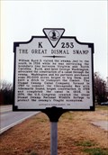 view gallery view galleryNE13.8 km | The Great Dismal Swamp in Virginia Historical Markers A marker for the swamp that covered more than one million acres at one time. posted by: Markerman62 location: Virginia date approved: 03/25/2015 last visited: 05/26/2015 |
 view gallery view gallerySE14.2 km |  First Post Road --- A-24 First Post Road --- A-24
in North Carolina Historical Markers Marker is at the intersection of Highway 32 N and Corapeake Road, in the median on Highway 32 N. Marker is in Corapeake, North Carolina, in Gates County posted by: Countrydragon location: North Carolina date approved: 01/29/2010 last visited: never |
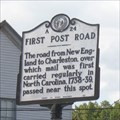 view gallery view gallerySE14.2 km |  First Post Road --- Corapeake in Gates County, North Carolina First Post Road --- Corapeake in Gates County, North Carolina
in First of its Kind Marker is in Corapeake, North Carolina, in Gates County. Marker is at the intersection of Highway 32 N (North Carolina Route 32) and Corapeake Road, in the median on Highway 32 N posted by: Countrydragon location: North Carolina date approved: 01/25/2010 last visited: never |
 view gallery view gallery N14.6 km N14.6 km
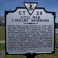
| Civil War Cavalry Skirmish in Virginia Historical Markers Erected 1998 by Department of Historic Resources. (Marker Number UT 28.) posted by: turnersrugs location: Virginia date approved: 03/31/2013 last visited: never |
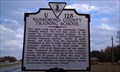 view gallery view galleryW16.3 km | Nansemond County Training School in Virginia Historical Markers Nansemond County Training School Historical Marker west of Holland on South Quay Road (US 58, eastbound lane, at intersection with Leafwood Rd). The actual building where this school was is about 2 miles down Leafwood. posted by: jdhowell location: Virginia date approved: 11/24/2010 last visited: 01/07/2013 |
 view gallery view gallery S19.3 km S19.3 km
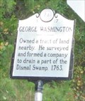
| George Washington -- A-17 in North Carolina Historical Markers Marker is near Corapeake, North Carolina, in Gates County. Marker is on Highway 32 N (North Carolina Route 32) south of Folly Road, on the left when traveling north posted by: Countrydragon location: North Carolina date approved: 01/29/2010 last visited: never |
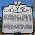 view gallery view galleryN19.3 km | Dumpling Island in Virginia Historical Markers Dumpling Island was the ceremonial heart of the Nansemond Indians. posted by: VirginiaSeeker location: Virginia date approved: 03/03/2007 last visited: 01/05/2013 |
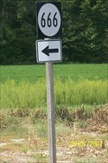 view gallery view galleryW20.9 km |  Rte 666 Rte 666
in 666 Sightings Get your kicks on Rte. 666 posted by: sfwife location: Virginia date approved: 09/10/2007 last visited: 01/25/2010 |
 view gallery view galleryN22.7 km | Nansemond Indian Villages in Virginia Historical Markers The principal villages of the Nansemond Indians stood just east of here on the Nansemond River posted by: VirginiaSeeker location: Virginia date approved: 03/03/2007 last visited: 05/26/2013 |
 view gallery view galleryN22.7 km |  Oakland Christian Church Oakland Christian Church
in Stained Glass Windows Beautiful stained glass windows in the Oakland Christian Church United Church of Christ in Suffolk, VA. posted by: fatcat161 location: Virginia date approved: 04/27/2009 last visited: 05/26/2013 |
 S22.9 km |  Jimmy's BBQ Jimmy's BBQ
in Classic BBQ and Sandwich Joints our only fast food place posted by: The Spotters location: North Carolina date approved: 03/22/2006 last visited: never |
 view gallery view gallery E23.5 km E23.5 km
|  Glencoe -- Chesapeake, VA Glencoe -- Chesapeake, VA
in Civil War Discovery Trail Sites Marker denoting the home of William Wallace, first lieutenant of the "Jackson Grays." posted by: Left Coast Labs location: Virginia date approved: 11/15/2010 last visited: 01/15/2014 |
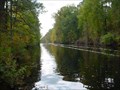
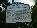 view gallery view galleryE23.5 km | North West Canal in Virginia Historical Markers Marker for a branch of the Dismal Swamp Canal. posted by: Left Coast Labs location: Virginia date approved: 09/27/2010 last visited: 04/07/2013 |
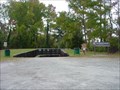 view gallery view galleryE23.5 km |  Great Dismal Swamp Boat Ramp - Chesapeake, VA Great Dismal Swamp Boat Ramp - Chesapeake, VA
in Boat Ramps Boat ramp on the Dismal Swamp Canal providing quick access to Lake Drummond. posted by: Left Coast Labs location: Virginia date approved: 11/12/2010 last visited: 07/14/2019 |
 view gallery view galleryE23.5 km |  Dismal Swamp Canal Trail -- Chesapeake, VA Dismal Swamp Canal Trail -- Chesapeake, VA
in Hiking and walking trailheads South trailhead for the Dismal Swamp Canal Trail. posted by: Left Coast Labs location: Virginia date approved: 09/19/2010 last visited: 04/07/2013 |
 view gallery view galleryE23.7 km | Dismal Swamp Canal -- Chesapeake, VA in Civil War Discovery Trail Sites Marker describes the significance and some of the actions associated with the Dismal Swamp Canal. posted by: Left Coast Labs location: Virginia date approved: 11/15/2010 last visited: 04/07/2013 |
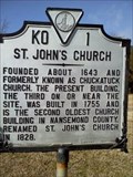 view gallery view galleryN23.8 km | St. John's Church in Virginia Historical Markers Erected 1961 by Virginia State Library. (Marker Number KO 1.) posted by: turnersrugs location: Virginia date approved: 03/31/2013 last visited: never |
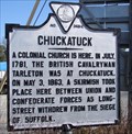 view gallery view galleryN23.8 km | Chuckatuck in Virginia Historical Markers Chuckatuck is a small village in the expansive city limits of Suffolk. posted by: VirginiaSeeker location: Virginia date approved: 03/03/2007 last visited: 04/02/2013 |
|