 view gallery view gallery E5.8 km E5.8 km
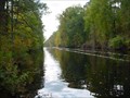
|   Dismal Swamp Canal -- A-12 Dismal Swamp Canal -- A-12
in North Carolina Historical Markers Located on Mullin Rd. near Main St. in South Mills NC posted by:  Countrydragon Countrydragon location: North Carolina date approved: 01/30/2010 last visited: 02/17/2013 |
 view gallery view gallery NE6 km NE6 km
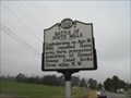
|  Dismal Swamp Canal -- South Mills, NC Dismal Swamp Canal -- South Mills, NC
in U.S. National Register of Historic Places Simple marker at the Dismal Swamp Canal Welcome Center annotating the canals placement on the register as District 8800528. posted by:  Left Coast Labs Left Coast Labs location: North Carolina date approved: 07/05/2010 last visited: 07/14/2019 |
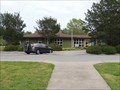 view gallery view galleryNE6 km |  Great Dismal Swamp Rest Area / Visitor Center - US Route 17 - South Mills, NC Great Dismal Swamp Rest Area / Visitor Center - US Route 17 - South Mills, NC
in Highway Rest Areas Located on US Route 17, 1 Mile south of the Virginia State Line in Camden County,The center is built on the banks of the Great Dismal Swamp Canal, this site provides traveler's information to both motorist and boater on the canal. posted by: outdoorboy34 location: North Carolina date approved: 01/27/2017 last visited: 11/23/2021 |
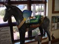 view gallery view galleryNE6 km |  "Tiny Timber" -- Dismal Swamp Canal Welcome Center "Tiny Timber" -- Dismal Swamp Canal Welcome Center
in Fiberglass Horses A member of the "Winged Horse Extravaganza" art projcet. Located inside the welcome center just off of US-17. posted by: Left Coast Labs location: North Carolina date approved: 07/13/2010 last visited: 07/14/2019 |
 view gallery view gallery SE9.7 km SE9.7 km
| Battle of South Mills -- A-8 in North Carolina Historical Markers Located on NC 343 between Nosay Rd. and Beechnut Ave. in South Mills NC posted by: Countrydragon location: North Carolina date approved: 01/30/2010 last visited: never |
 view gallery view gallery N15.9 km N15.9 km
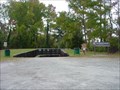
|  Great Dismal Swamp Boat Ramp - Chesapeake, VA Great Dismal Swamp Boat Ramp - Chesapeake, VA
in Boat Ramps Boat ramp on the Dismal Swamp Canal providing quick access to Lake Drummond. posted by: Left Coast Labs location: Virginia date approved: 11/12/2010 last visited: 07/14/2019 |
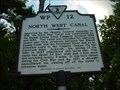 view gallery view galleryN16.1 km |  North West Canal North West Canal
in Virginia Historical Markers Marker for a branch of the Dismal Swamp Canal. posted by: Left Coast Labs location: Virginia date approved: 09/27/2010 last visited: 04/07/2013 |
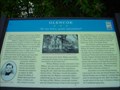 view gallery view galleryN16.1 km |  Glencoe -- Chesapeake, VA Glencoe -- Chesapeake, VA
in Civil War Discovery Trail Sites Marker denoting the home of William Wallace, first lieutenant of the "Jackson Grays." posted by: Left Coast Labs location: Virginia date approved: 11/15/2010 last visited: 01/15/2014 |
 view gallery view gallerySE16.3 km |  Camden Water Tower Camden Water Tower
in Water Towers The Camden Water Tower is on Rt. 343 about 5 miles NW of Camden Court House. posted by: VirginiaSeeker location: North Carolina date approved: 08/07/2006 last visited: never |
 view gallery view galleryN16.3 km |  Dismal Swamp Canal Trail -- Chesapeake, VA Dismal Swamp Canal Trail -- Chesapeake, VA
in Hiking and walking trailheads South trailhead for the Dismal Swamp Canal Trail. posted by: Left Coast Labs location: Virginia date approved: 09/19/2010 last visited: 04/07/2013 |
 view gallery view gallery W16.9 km W16.9 km
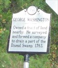
| George Washington -- A-17 in North Carolina Historical Markers Marker is near Corapeake, North Carolina, in Gates County. Marker is on Highway 32 N (North Carolina Route 32) south of Folly Road, on the left when traveling north posted by: Countrydragon location: North Carolina date approved: 01/29/2010 last visited: never |
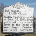 view gallery view gallerySE16.9 km | Nathaniel Batts Land Grant -- A-64 in North Carolina Historical Markers Located on US 17, Elizabeth City, NC, USA posted by: Countrydragon location: North Carolina date approved: 02/11/2010 last visited: never |
 view gallery view galleryNE17.7 km | Seven Patriot Heroes in U.S. Civil War Sites Erected by Virginia Civil War Trails posted by: turnersrugs location: Virginia date approved: 03/06/2013 last visited: never |
 view gallery view gallery NW18.5 km NW18.5 km
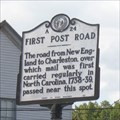
|  First Post Road --- Corapeake in Gates County, North Carolina First Post Road --- Corapeake in Gates County, North Carolina
in First of its Kind Marker is in Corapeake, North Carolina, in Gates County. Marker is at the intersection of Highway 32 N (North Carolina Route 32) and Corapeake Road, in the median on Highway 32 N posted by: Countrydragon location: North Carolina date approved: 01/25/2010 last visited: never |
 view gallery view galleryNW18.5 km | First Post Road --- A-24 in North Carolina Historical Markers Marker is at the intersection of Highway 32 N and Corapeake Road, in the median on Highway 32 N. Marker is in Corapeake, North Carolina, in Gates County posted by: Countrydragon location: North Carolina date approved: 01/29/2010 last visited: never |
 W19.3 km |  Jimmy's BBQ Jimmy's BBQ
in Classic BBQ and Sandwich Joints our only fast food place posted by: The Spotters location: North Carolina date approved: 03/22/2006 last visited: never |
 view gallery view galleryN19.6 km |  CFD Station 13 CFD Station 13
in Firehouses Fire Station 13 is located in the rural southern portion of Chesapeake. The first run area of the Station consists of mostly rural farm land with some light industry. The Chesapeake Municipal Airport is also located within this run area posted by: Left Coast Labs location: Virginia date approved: 08/26/2011 last visited: 01/13/2014 |
 view gallery view galleryN19.8 km | Dismal Swamp Canal -- Chesapeake, VA in Civil War Discovery Trail Sites Marker describes the significance and some of the actions associated with the Dismal Swamp Canal. posted by: Left Coast Labs location: Virginia date approved: 11/15/2010 last visited: 04/07/2013 |
 view gallery view gallerySE20 km |  Petsense - Commercial Blvd - Elizabeth City, NC Petsense - Commercial Blvd - Elizabeth City, NC
in Pet Stores This is the Petsense location in Elizabeth City, NC. posted by: retail96 location: North Carolina date approved: 10/12/2018 last visited: never |
 view gallery view gallerySE20.1 km |  Walmart - Tanglewood Pkwy - Elizabeth City, NC Walmart - Tanglewood Pkwy - Elizabeth City, NC
in WAL*MART Stores This is the Walmart Supercenter in Elizabeth City, NC. posted by: retail96 location: North Carolina date approved: 10/06/2018 last visited: 10/06/2018 |
 view gallery view galleryNE20.1 km |  North Carolina Welcome Center - Currituck, NC North Carolina Welcome Center - Currituck, NC
in Tourist Information Centers - Visitor Centers This welcome center is located right on the border, just about 20 feet south from Virginia. posted by: bluesnote location: North Carolina date approved: 09/23/2012 last visited: 09/23/2012 |
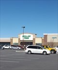
 view gallery view galleryE20.3 km |  Dollar Tree - Caratoke Hwy - Moyock, NC Dollar Tree - Caratoke Hwy - Moyock, NC
in Dollar Stores This is the Dollar Tree location in Moyock, NC. posted by: retail96 location: North Carolina date approved: 10/20/2018 last visited: never |
 view gallery view gallerySE20.3 km | Dollar Tree - Conlon Way - Elizabeth City, NC in Dollar Stores This is one of the two Dollar Tree locations in Elizabeth City, NC. posted by: retail96 location: North Carolina date approved: 10/13/2018 last visited: never |
 view gallery view galleryNE20.3 km | First Dividing Line ---- Moyock in Currituck County, North Carolina in First of its Kind Marker is in Moyock, North Carolina, in Currituck County. Marker is at the intersection of Caratoke Highway (Route 168) and North Point Road, on the right when traveling south on Caratoke Highway posted by: Countrydragon location: North Carolina date approved: 01/31/2010 last visited: 09/21/2021 |
 view gallery view galleryNE20.3 km | Dividing Line --- A-6 in North Carolina Historical Markers Marker is in Moyock, North Carolina, in Currituck County. Marker is at the intersection of Caratoke Highway (Route 168) and North Point Road, on the right when traveling south on Caratoke Highway posted by: Countrydragon location: North Carolina date approved: 02/14/2010 last visited: 09/14/2012 |
|